Download
1 / 9
90 likes | 112 Vues
Public meetings to discuss the South Kona Flood Hazard Study, methodology, and receive community input. Study authorized under Section 206 of the Flood Control Act of 1960 for floodplain management services program. Historical floods and scope of work included.

E N D
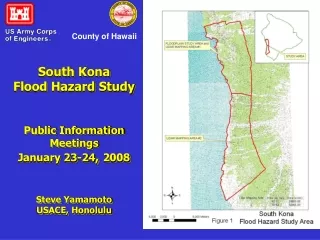
South KonaFlood Hazard StudyPublic Information MeetingsJanuary 23-24, 2008Steve YamamotoUSACE, Honolulu County of Hawaii
Purpose • Discuss Corps of Engineers’ study authority • Provide information and status on the South Kona Flood Hazard Study • Discuss study area, methodology and products • Gather input from community
Study Authority Authority: Section 206 of the Flood Control Act of 1960, as amended (Flood Plain Management Services Program) Purpose: To encourage prudent use of the Nation’s flood plains for the benefit of the national economy and general welfare by supporting comprehensive flood plain management at all governmental levels.
FPMS Program • TECHNICAL SERVICES • Obtain, develop or interpret flood plain data which includes: • providing historical data on flooding • establishing flood frequency • determining flood stage
FPMS Program • TECHNICAL SERVICES (cont.) • determining extent of flood plains • establishing regulatory floodways • providing site specific flood hazard evaluations • inventory of flood prone structures • post flood studies
South Kona Flooding • Historical Floods • March 1956 8-12 inches in 3-hr period • April 1963 4 inches in 2 hours • Nov 1967 4 inches in 2 ½ hrs • May 1976 5 inches in 4 hours • Nov 2007 7 ½ inches in 4 hours
South Kona Flood StudyScope of Work • Collect lidar topographic survey data for 142 sq. mi. • Gather flood information at public meetings • Conduct hydrologic and hydraulic analyses to determine flood hazards within the study area • Prepare report and flood maps documenting study results • Process maps for FEMA FIRM revisions
South Kona Flood StudySchedule • Current Study Schedule • Execute Study Agreement June 2007 • Award Lidar Topographic Contract Sept 2007 • Award Floodplain Hydraulics Contract Jan 2008 • Conduct initial public meeting Jan 2008 • Complete Draft report and flood maps Sept 2008 • Conduct second public meeting Oct 2008 • Complete Final report and flood maps and submit results to FEMA Nov 2008
Points of Contact • Steven Yamamoto, USACE, Project Manager • 438-0881 • Steven.H.Yamamoto@usace.army.mil • Milton Yoshimoto, USACE, Project Manager • 438-2250 • Milton.T.Yoshimoto@usace.army.mil • Jeff Overton, Group 70, Chief Environmental Planner • 523-5866 • Massoud Rezakani, MRC, Principal • 480 656-2304 • Galen Kuba, Chief of Engineering Div, County of Hawaii DPW • 961 8422