Download
1 / 21
210 likes | 318 Vues
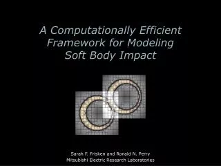
A Computationally Efficient Platform to Examine the Efficacy of Regional Downscaling Methods. AGU Fall Meeting Abstract GC12C-04. Jonathan L. Vigh 1 , Caspar M. Ammann 1 , Richard B. Rood 2 , Joseph J. Barsugli 3 , and Galina Guentchev 1

E N D
A Computationally Efficient Platform to Examine the Efficacy of Regional Downscaling Methods AGU Fall Meeting Abstract GC12C-04 Jonathan L. Vigh1, Caspar M. Ammann1, Richard B. Rood2, Joseph J. Barsugli3, and Galina Guentchev1 1. Climate Science and Applications Program, Research Applications Laboratory, NCAR 2. University of Michigan 3. CIRES/University of Colorado Boulder http://earthsystemcog.org/projects/ncpp/
The Problem • Ever-expanding sets of climate projections • Proliferation of downscaling methods • Need for translation: application- and discipline-specific metrics • Need for standardization and interoperability with other tools • Need for high level of extensibility • Need for evaluation
The Solution: Quantitative Evaluation The NCPP team is working: • To advance community-coordinated provision of regional and local knowledge about the evolving climate • To accelerate its use in adaptation planning an decision making • Facilitating the development of application-oriented communities • Developing standards, recommendations and guidance for use of localized climate predictions & projections • Developing a flexible evaluation platform that offers performance metrics on methods, data and tools. The Evaluation Engine
Evaluation Framework We have initially focused on evaluation of present observed climate aiming to evaluate the different attributes of the various downscaling methods
Water Resources Agriculture Human Health Ecosystems Mean Max Min p5 p10 p25 Median p75 p90 p95 St Dev Downscaling ETCCDI Extremes Indices Human Health Indices BIOCLIM Indices
Data Challenges Lack of standardized data: • Differing metadata • Different calendaring systems • Missing coordinate arrays 4.4 GB files of daily surface data: • Tas, TasMax, TasMin, Pr, DTR • 1971-2000 • Lower 48 U.S. Nearly 1 TB of input data • Observational Input Datasets • Maurer02v2 (12 km) • Maurer02v2 (regridded to 50km) • Daymet2.1 (regridded to 12km) • Types of Model Input Datasets • Asynchronous Regional Regression Model • (ARRM) at 12 km from 16 GCMs • Bias-Correction Constructed Analogs (BCCA) at 12 km from 10 GCMs • Dynamical Downscaling • NARCCAP at 12 and 50 km • Perfect Model w/ ARRM & Perfect Model Target Coming soon: Univ. of Delaware, Berkeley Earth, etc. + more fields (variables)
Data Flows: Incremental Processing Engine implemented in NCAR Command Language (NCL) Automated job submission allows for massive parallel processing Open Climate GIS
Metadata Standards The result of the evaluation & comparison is ~159,000 plots and datasets NCPP Team has developedmetadata descriptors and standards • Common Information Model (CIM) developed byEarth System Model Documentation (ES-DOC) Project • New controlled vocabulary for regional downscaling to describe the eval & and comparison • Descriptors agreed upon by larger team (NASA/NOAA/Euro-CORDEX) Metadata facilitates capability for finding, accessing and using the products using the controlled vocabulary: • For search, access and comparison • Either through web interface or through machine search by tapping into the Earth System Grid Federation (ESGF) For the first time, all products come with full metadata info Success stories • Using these descriptors, the GFDL group published the Perfect Model on their ESGF node • Nasa AIMES team published the new 800 m BCSD on their node
Metadata Standards The result of the evaluation & comparison is ~159,000 plots and datasets NCPP Team has developedmetadata descriptors and standards • Common Information Model (CIM) developed byEarth System Model Documentation (ES-DOC) Project • New controlled vocabulary for regional downscaling to describe the eval & and comparison • Descriptors agreed upon by larger team (NASA/NOAA/Euro-CORDEX) Metadata facilitates capability for finding, accessing and using the products using the controlled vocabulary: • For search, access and comparison • Either through web interface or through machine search by tapping into the Earth System Grid Federation (ESGF) For the first time, all products come with full metadata info Success stories • Using these descriptors, the GFDL group published the Perfect Model on their ESGF node • Nasa AIMES team published the new 800 m BCSD on their ESGF node
CoG Advanced Data Search: Evaluation Database and Metadata • Directory structure utilizes the metadata schema with one unique dataset at the end of each branch: • the NetCDFdataset • the XML metdata • the visualization (png)
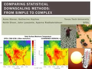
Means are often relatively well represented, but differences towards the tails of distributions, extremes are vital to understand
Summary Benefits of the evaluation engine: • Highly efficient, flexible, extensible, interoperable with end-to-end parallelized workflow • Implemented with standards and metadata allowing comprehensive search • Allows users to get the information they need by reducing content • Gives users information about the properties of the climate data • Both distribution and uncertainty • Makes the production and assumptions of the data transparent
Future Capabilities • Examples of future directions under consideration: • Ensembles (Gradient-preserving? Optimum blending?) • Extreme value analysis (e.g. return periods) • More application group-related indices and more user groups • On-demand (precalculated) vs. on-the-fly capability • More user-friendly interface with curated discipline-specific ‘collections’ • Intercomparison of future projections • NCPP needs your input: • NCPP website: • NCPP evaluation & comparison data: http://earthsystemcog.org/projects/ncpp/ http://earthsystemcog.org/search/downscaling-2013/
Listing of All Indices » bioclim1 (1) » bioclim2 (1) » bioclim3 (1) » bioclim4 (1) » bioclim5 (1) » bioclim6 (1) » bioclim7 (1) » bioclim8 (1) » bioclim9 (1) » bioclim10 (1) » bioclim11 (1) » bioclim12 (1) » bioclim13 (1) » bioclim14 (1) » bioclim15 (1) » bioclim16 (1) » bioclim17 (1) » bioclim18 (1) » bioclim19 (1) » fd (52) » hd30 (52) » hd35 (52) » hd38 (52) » hd40 (52) » hd45 (52) » id (52) » r10mm (52) » r1mm (52) » r20mm (52) » rx1day (52) » sd (52) » tnn (48) » tnx (48) » tr (52) » txn (48) » txx (48) tas tasmax tasmin pr dtr