Download
1 / 24
240 likes | 406 Vues
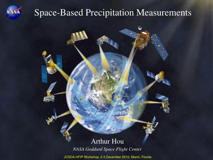
Space-Based Precipitation Measurements. Arthur Hou NASA Goddard Space Flight Center. JCSDA-HFIP Workshop, 2-3 December 2010, Miami, Florida. Current Generation of Global Precipitation Products.

E N D
Space-Based Precipitation Measurements Arthur Hou NASA Goddard Space Flight Center JCSDA-HFIP Workshop, 2-3 December 2010, Miami, Florida
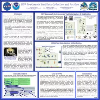
Current Generation of Global Precipitation Products Current multi-satellite products are based on MW or MW+IR observations from uncoordinated satellite missions using a variety of merging techniques TRMM Realtime 3hr global rain map at 0.25o resolution 50N 50S • TRMM radar provided an anchor for rainfall estimates by passive microwave sensors in the tropics and subtropics. • Further advances require better sensors and remote-sensing algorithms (especially for light rain and falling snow).
Lessons from TRMM • Detailed knowledge of precipitation microphysical properties (particle size distribution, liquid/ice partition, hydrometeor profiles, etc.) is key to improving precipitation retrievals from passive microwave sensors • - Dual-frequency or dual-polarimetric radar capabilities • A better understanding of global water fluxes & precipitation characteristics (frequency, intensity, distribution, etc.) in a changing climate requires improved measurements of light rain and snow. - Light rain and snowfall account for ~50% of precipitation events and significant afractions of precipitation volume outside the Tropics • “High frequency” water vapor channels are key to improving precipitation retrievals over land, especially over frozen terrains • Ground validation must go beyond direct comparison of surface rain rates between ground and satellite measurements to provide the means for improving satellite simulators, retrieval algorithms, & model applications • Near-realtime “asynoptic” observations between those by polar orbiters at fixed local times have high operational values in hurricane monitoring - TMI data account for 16% of all tropical cyclone position fixes made by the Joint Typhoon Warning Center in a typical year
GPM Mission Concept GPM Reference Concept Low Inclination Observatory (40o) GMI (10-183 GHz) (NASA & Partner, 2014) GPM Core Observatory (65o) DPR (Ku-Ka band) GMI (10-183 GHz) (NASA-JAXA, LRD 2013) Unify and advance precipitation measurements from space to provide next-generation global precipitation products within a consistent framework • Enhanced capability for cinear realtime monitoring ciof hurricanes & cimidlatitude storms • Improved estimation of cirainfall accumulation • Precipitation physics observatory • Transfer standard for inter-satellite calibration of constellation sensors Coverage & Sampling Key Advancement Using an advanced radar/radiometer measurement system to improve constellation sensor retrievals Partner Satellites: GCOM-W1 DMSP F-18, F-19 Megha-Tropiques MetOp, NOAA-19 NPP, JPSS (over land) • 1-2 hr revisit time over land • < 3 hr mean revisit time over 90% of globe
GPM Observations from Non-Sun-Synchronous Orbits Near real-time observations filling gaps between those of polar orbiters at fixed time of the day for: • Intercalibration of polar-orbiting msensors over wide range of latitudes • Near real-time monitoring of mhurricanes & midlatitude storms • Improved accuracy of rain volume • estimation • Resolving diurnal variability in mrainfall climatologym Monthly Samples as a Function of the Time of the Day(1o x 1o Resolution) TRMM: 3652 “asynoptic” samples GPM Core+LIO: 6175 samples Core+LIO: 4298 samples
NASA-JAXA GPM Core Observatory Core Observatory Measurement Capabilities Dual-Frequency (Ku-Ka band) Precipitation Radar (DPR): • Increased sensitivity (~12 dBZ) for light rain and snow detection relative to TRMM • Better measurement accuracy with differential attenuation correction • Detailed microphysical information (DSD mean mass diameter & particle no. density) & identification of liquid, ice, and mixed-phase regions Multi-Channel (10-183 GHz) GPM Microwave Imager (GMI): • Higher spatial resolution (IFOV: 6-26 km) • Improved light rain & snow detection • Improved signals of solid precipitation over land (especially over snow-covered surfaces) • 4-point calibration to serve as a radiometric reference for constellation radiometers Combined Radar-Radiometer Retrieval • DPR & GMI together provide greater constraints on possible solutions to improve retrieval accuracy • Observation-based a-priori cloud database for constellation radiometer retrievals
Measurable range by 35.55 GHz radar Measurable range by 13.6GHz radar Rainrate Occurrence tropical rain mid- & high- latitude rain & snow Rain-rate heavy rain light rain/snow Simulated Error Std Dev in Rain Retrieval TRMM Percent GPM ~12.5 mm/h ~1.5 mm/h Rain Rate (mm/h) Courtesy Z. Haddad DPR capabilities relative to TRMM PR JAXA/NICT Dual-Frequency Precipitation Radar CloudSat data show that light rain rates between 0.2-0.5 mm/hr account for 16% of the rain volume < 2.0 mm/hr. With Ku and Ka bands, GPM will capture ~98% of total global rain volume. 40N-40S Courtesy of Wes Berg
NOAA NEXRAD Data AMSU-B 89 GHz AMSU-B 183.3 ± 7 GHz Snow Retrieval Comparison of GMI resolution with other radiometers AMPR (Aircraft) GMI (Core) AMSR-E TMI SSMIS Synthesized Brightness Temperatures (R. Hood) g m3 Feasibility demonstration of snowfall retrieval using HF channels Radar reflectivity of the March 5-6, 2001 New England blizzard (75 cm of snow fell on Burlington, VT) Surface effects screened by water vapor. Snowfall appears as low brightness temperatures Cannot distinguish surface from cloud effects. GMI capabilities 4 in/hr G. Skofronick-Jackson
Passive Microwave Sensor Characteristics in the GPM Era V – Vertical Polarization H – Horizontal Polarization Constellation microwave sensor channel coverage Mean Spatial Resolution (km) Different center frequencies, viewing geometry, and spatial resolution must be reconciled
Inter-Satellite Calibration of Microwave Radiometers • Objective: Quantify and reconcile differences between similar but not identical microwave radiometers to produce self-consistent global precipitation estimates • X-Cal (Imagers):Convert observations of one satellite to virtual observations of another using non-Sun-synchronous satellite as a transfer standard (e.g. TMI or GMI) • Develop corrections for recurring instrument errors and implementation strategy for routine intercalibration of constellation radiometers • Bias correction a function of orbital phase and solar beta angle • Agreement between different methods ~ 0.3 K TMI Bias Correction Table (K) NOAA 17 183 ±3 GHz (Ocean) • X-Cal (Sounders): • Double differencing using forecast residual as primary transfer standard to provide a basis for calibration consistency • Collaboration with NWP centers (MHS-ECMWF)-(AMSU_B-ECMWF) Courtesy of Bauer (ECMWF) Hanna, Weng, & Yan (NOAA) GPM International X-Cal Working Group (NASA, NOAA, JAXA, CNRS, EUMETSAT, CMA, CONAE, GIST, & universities) in coordination with WMO/CGMS GSICS
- Radar for vertical structural details • Radiometers for horizontal coverage • A radar-radiometer system for a common transfer standard GPM Strategy to Global Precipitation Estimation • DPR Retrievals: • A characteristic size parameter (D0) of the PSD • estimated from the difference (in dB) between • Ku- and Ka-band radar reflectivity factors • Ambiguities include unknown shape parameter • () of the gamma PSD distribution and the snow • mass density () • Characteristic number concentration of PSD • is given by D0 and the radar equation • Step-by-step estimation of attenuation correction • based on PSD estimates • Precipitation rate and the equivalent water • content are derived from the PSD for an • assumed velocity distribution RAIN SNOW Meneghini et al., NASA/GSFC
Using GMI radiance measurements as additional constraints on the • DPR profiling algorithm: • Assumptions regarding the particle size distribution, ice microphysics, cloud water and water vapor vertical distribution are refined using a variational procedure that minimizes departures between simulated and observed brightness temperatures - according to the sensitivity of simulated brightness temperatures to assumptions in DPR retrievals. • Retrievals are consistent with both DPR reflectivities and GMI radiances wwithin a maximum-likelihood estimation framework. • Construction of an a-priori database that relates hydrometeors to bbrightness temperatures over the range of observed Tb values for pprecipitation retrievals from constellation radiometers. • Pre-launch algorithm advances focus on retrievals of solid precipitation pand physical retrievals over land: • Modeling of nonlinear, under-constrained relationships between physical characteristics of precipitation particles and microwave observations • Characterization of land surface variability/emissivity Combined DPR+GMI retrievals
International Collaborations on GPM GV • Joint field campaigns • National networks and other ground assets (radar, gauges, etc.) • Hydrological validation sites (streamflow gauges, etc.) LPVEx (2010) NASA-EC Snowfall (2012) MC3E (2011) Pre-CHUVA (2010) 15 Active International Projects • GPM Joint Field Campaigns: • Joint campaign with Brazil on warm rain retrieval over land in Alcântara, 3-24 March 2010 • Light Precipitation Validation Experiment (LPVEx): CloudSat-GPM light rain in shallow melting layer situations in Helsinki, Finland, 15 Sept - 20 Oct 2010 • Mid-Latitude Continental Convective Clouds Experiment (MC3E): NASA-DOE field campaign in central Oklahoma, Apr-May 2011 • High-Latitude GPM Cold-Season Precipitation Experiment (GCPEX): Joint campaign with Environment Canada on snowfall retrieval in Ontario, Canada, Jan-Feb 2012 • Hydrological validation with NOAA HMT in 2013 (under development)
Next-Generation Global Precipitation Products GPM Core: Reference Standard for Constellation Radiometers • Intercalibrated constellation radiometric data reconciling differences in center frequency, viewing geometry, resolution, etc. • Converting observations of one satellite to virtual observations of another using non-Sun-synchronous satellite as a transfer standard • GMI employsan encased hot load design (to minimize solar intrusion) and noise diodes for nonlinearity removal to attain greater accuracy & stability • Unified precipitation retrievals using a common cloud database constrained by DPR+GMI measurements from the Core Observatory Prototype GPM Radiometer Retrieval Optimally matching observed Tb with simulated Tb from an a priori cloud database Simulated Tb Observed Tb Comparison of TRMM PR surface rain with TMI rain retrieval using an cloud database consistent with PR reflectivity and GMI multichannel radiances TRMM uses a model-generated cloud database GPM uses a DPR/GMI-constrained database
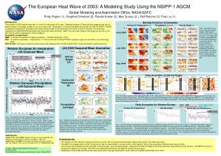
ECMWF Hurricane Charley track forecasts from analysis 2004081112 Rain Ass Cyclone disappeared in operational forecast without rain assimilation Courtesy of P. Bauer/ECMWF Applications for hurricane monitoring & prediction Hurricane Tracking Numerical Weather Prediction Position Error in Nautical Miles Precipitation observations are in operational use at ECMWF, NCEP, JMA, and other NWP centers.
Summary (1/2) • GPM is an international satellite mission that will unify and advance precipitation measurements from a constellation of microwave sensors for scientific research and societal applications. • GPM is in the implementation phase at NASA and JAXA • Core Observatory Launch Readiness Date: 21 July 2013 • Key advances include • More accurate instantaneous precipitation information, especially light rain & solid precipitation • Better space-time coverage through international partnership • High spatial resolution (DPR & GMI on Core Observatory) • Next-generation global precipitation products building on intercalibrated constellation radiometric measurements and unified physical retrievals using a common observation-constrained hydrometeor database • NASA Precipitation Processing System is currently producing • Prototype intercalibrated L1 products for TMI, SSMI, AMSR-E, SSMIS, & WindSat • L3 merged global precipitation products using TMI, SSMI, AMSR-E, AMSU, & MetOp in near real-time for research & applications
Summary (2/2) • GPM is a science mission with integrated applications goals: • MW imaging and precipitation rates available within 1 hr of observation from two GMI’s in non-Sun-synchronous orbits for near real-time applications • DPR reflectivity and combined DPR+GMI precipitation products available within 3 hr of observation • Ground validation is key to pre-launch algorithm development and post-launch product evaluation. • NASA is conducting a series of joint field campaigns with domestic & international partners to refine algorithm assumptions & parameters. • Synergy with NWP in areas such as radiometer intercalibration, observation operator development, and model physics improvement
DPR Instrument Characteristics * Minimum detectable rainfall rate is defined by Ze=200 R1.6 (TRMM/PR: Ze=372.4 R1.54 )
GMI Instrument Characteristics Deployed Size: 1.4 m x 1.5 m x 3.5 m Antenna Size: 1.2 m Swath: 885 km Resolution and swath for GMI on Core Data Rate: ~30 kbps Power: 162 Watts Mass: 166 kg * Analysis data as of May 2010
Current Capability:< 3h over 45% of globe Extended Life Prime Life GPM Constellation Sampling and Coverage Baseline Constellation Schedule GPM (2015):< 3h over 90% of globe GPM Core Launch Hour 1-2 hr revisit time over land with inclusion of sounders
Refine algorithm assumptions & parameters - Characterize uncertainties in satellite retrievals & GV measurements “Truth” is estimated through the convergence of satellite and ground-based estimates Role of GPM Ground Validation • Pre-launch algorithm development & post-launch product evaluation • Three complementary approaches: • Direct statistical validation (surface): • - Leveraging off operational networks to identify and resolve first-order discrepancies between satellite and ground-based precipitation estimates • Physical process validation (vertical column): • - Cloud system and microphysical studies geared toward testing and refinement of physically-based retrieval algorithms • Integrated hydrologic validation/applications (4-dimensional): • - Identify space-time scales at which satellite precipitation data are useful to water budget studies and hydrological applications; characterization of model and observation errors
Science Partnership with NOAA on GPM • Level 1 radiometer intercalibration (partnership through GSICS & PMM) • -Using NWP forecast residuals for sounder intercalibration • Level 2 precipitation algorithms (NOAA PI’s on PMM Science Team) • Land surface characterization for physically based retrieval • Precipitation microphysical properties • Statistical validation • - Collaboration with NOAA NMQ for validation and product enhancement • Hydrological applications/validation • - Joint field campaigns with NOAA HMT (e.g. HMT-SE) • Level 3 multi-satellite product development • Moving towards U.S. national products (global & regional) • Combined satellite & ground-based measurements • Level 4 dynamic downscaling • WRF ensemble data assimilation using NOAA operational data streams