Download
1 / 39
390 likes | 536 Vues
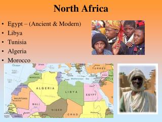
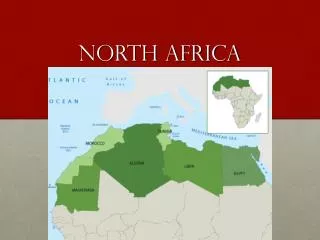
North Africa. Geography: The World and Its People Chapter 17. Chapter 17: North Africa. Chapter 17 Section 1. Egypt. The Nile River. The Nile River is the lifeline of Egypt Supplies 85% of Egypt’s water 3 Gifts of the Nile Water Fertile Soil Transportation. Egypt’s Land.

E N D
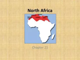
North Africa Geography: The World and Its People Chapter 17
Chapter 17 Section 1 Egypt
The Nile River • The Nile River is the lifeline of Egypt • Supplies 85% of Egypt’s water • 3 Gifts of the Nile • Water • Fertile Soil • Transportation
Egypt’s Land Egyptian Desert 3 Main Land Areas • Nile River Valley • Begins in East Africa • Flows North Through Sudan into Egypt to Mediterranean Sea • Sinai Peninsula • Actually Part of Southwest Asia • Desert Areas • Cover Most of Egypt
Economy Egypt's Economy Harvesting Cotton in Egypt • Agriculture • Still Egypt’s main economic activity • Only 4% of land used for farming (along Nile River) • Grow cotton, dates, vegetables, sugarcane, and wheat • Cotton is Egypt’s leading agricultural export
Economy Cont. Alexandria, Egypt. Gas fired plant on the Nile Delta. Egypt's Economy • Industry • Cairo and Alexandria are main industrial centers • Factories produce food products, textiles, and consumers goods • Oil is Egypt’s main mineral resource
The Aswan High Dam • Provides Hydroelectric Power • Allows Fellahin to plant crops two or three times a year • Stops flow of Silt, which makes the soil fertile • Farms now rely on expensive fertilizers • Causes salty water from Mediterranean to flow into Nile River Delta
Egypt’s People • Most people live within 20 miles of the Nile River • 55% live in rural areas • Most Fellahin are subsistence farmers • Extra food is sold at bazaar, or marketplace • Cairo is the capital and largest city in Egypt, and all of Africa • Cairo is growing because of high birthrates in Egypt, and Fellahin are moving to cities to find work Cairo, Egypt
Egypt History • One of the ancient world’s most advanced civilizations • Ruled by Pharoahs • Hieroglyphs • Made paper from papyrus • Created a calendar • Built lasting monuments • Pyramids, Sphinx • Conquered by several groups over centuries • Is now Arabic and Islamic Great Pyramids of Giza, Egypt
Egypt Today • Became a Republic in 1953 • Gamal Abdel Nasser: President from 1954-1970 • Nasser opposed Israel, and took control of the Suez Canal • Britain, France, and Israel invaded Egypt to regain control of canal • UN convinced countries to settle their differences Suez Canal from Space
QUIZ 17-1 Egypt
Particles deposited by a river • Fellahin • Hydroelectric Power • Silt • Bazaar • Delta
A triangle-shaped area of land at a river’s mouth • Fellahin • Hydroelectric Power • Silt • Bazaar • Delta
Electric energy from moving water • Fellahin • Hydroelectric Power • Silt • Bazaar • Delta
Egyptian farmers • Fellahin • Hydroelectric Power • Silt • Bazaar • Delta
marketplace • Fellahin • Hydroelectric Power • Silt • Bazaar • Delta
Most of Egypt has a… • Tropical Climate • Mediterranean Climate • Desert Climate • Polar Climate
Most of Egypt’s water supply comes from the • Mediterranean Sea • Atlantic Ocean • Suez Canal • Nile River
The section of Egypt that is actually a part of Southwest Asia is the… • Sinai Peninsula • Libyan Desert • Aswan High Dam • Nile Valley
Egypt’s leading agricultural export is… • Vegetables • Wheat • Dates • Cotton
The largest city in Egypt is… • Alexandria • Suez • Cairo • Aswan
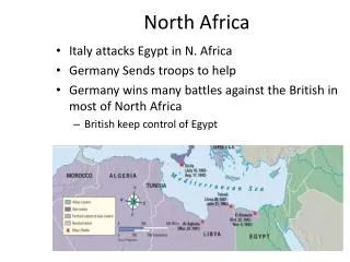
Chapter 17 Section 2 Other North African Countries
Libya • Capital is Tripoli • More than 90% desert • Poor until the discovery of oil in 1959 • Has 5 million people of mixed Arab and Berber ancestry • 70 percent of people live in cities near the Mediterranean coast • In 1969 a dictatorship was set up by Muammar al-Qaddhafi Desert in Libya
Tunisia • Capital City is Tunis • Former French colony • Belongs to region known as Maghreb, or “The West” • Includes large areas of the Sahara Desert and Rugged Atlas Mountains • Depends on agriculture and Mining • 60% of Tunisia’s 9 million people live in urban areas • Ancient city of Carthage, which fought unsuccessfully against Rome for control of Mediterranean Shepherding in the Atlas Mountains
Algeria • Capital City is Algiers • Largest country in North Africa • Has deserts, mountains, and plains • Between Atlas and Ahaggar Mountains are ergs • Narrow strip of farmland along Mediterranean called the Tell, which is the arabic word for “hill” • Economy depends on mining, agriculture, and manufacturing • Most of Algeria’s 28 million people practice Islam and speak Arabic • Old areas of Algiers called casbahs, section of shops, bazaars, and mosques
Morocco • Capital city is Rabat • Located in Northwest corner of Africa • Most of 29 million people are of mixed Arab and Berber ancestry • Land: Coastal plain, Atlas Mountains, Sahara Desert • Economy depends on agriculture, mining, tourism, and fishing • From 1000’s to early 1900’s Morocco was a Muslim kingdom • In 1900’s ontrolled by France and Spain • Became Independent kingdom again in 1956
QUIZ 17-2 Other North African Countries
A government under one all-powerful leader • Tell • Ergs • Dictatorship • Casbahs • Algiers
Old sections of Algiers with shops, mosques, and bazaars • Tell • Ergs • Dictatorship • Casbahs • Algiers
Arabic word meaning “hill” • Tell • Ergs • Dictatorship • Casbahs • Algiers
Huge areas of shifting sand dunes • Tell • Ergs • Dictatorship • Casbahs • Algiers
Capital of Algeria • Tell • Ergs • Dictatorship • Casbahs • Algiers
Libya became wealthy because of the discovery of… • Uranium • Water • Gold • Oil
More than 90% of Libya is… • Water • Swampland • Desert • Farmland
Tunisia, Algeria, and Morocco from a region known as the… • Sahara • Maghreb • Egypt • Algeria
The largest country in North Africa is … • Tunisia • Morocco • Egypt • Algeria
The major economic activities of Morocco are agriculture, mining, and… • Heavy industry • Tourism • Oil production • Manufacturing
Results Further Questions?