Download
1 / 1
10 likes | 200 Vues
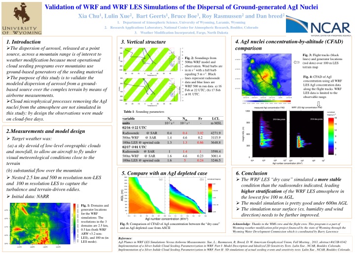
4 . AgI nuclei concentration-by-altitude (CFAD) comparison. 3 . Vertical structure. 1. Introduction

E N D
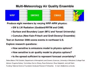
4. AgInuclei concentration-by-altitude (CFAD) comparison 3. Vertical structure • 1. Introduction • The dispersion of aerosol, released at a point source, across a mountain range is of interest to weather modification because most operational cloud seeding programs over mountains use ground-based generators of the seeding material • The purpose of this study is to validate the modeled dispersion of aerosol from a ground-based source over the complex terrain by means of airborne measurements. • Cloud microphysical processes removing the AgI nuclei from the atmosphere are not simulated in this study: by design the observations were made on cloud-free days. Fig. 3: Flight tracks (black lines) and generator locations (red dots) over 100 m LES terrain map Fig. 2: Soundings from 500m WRF model and observation. Wind barbs are in m s-1 with a full barb equaling 5 m s-1. Black lines represent radiosonde data and blue lines are WRF 500 m run data. a) 16 Feb at 22 UTC; (b) 17 Feb at 01 UTC. Fig. 4: CFAD of AgI concentration using all WRF LES AgI concentration data along the flight tracks. WRF LES data is limited to the observable range. Table 1: Sounding parameters • 2.Measurements and model design • Target weather was: • (a) a sky devoid of low-level orographic clouds and snowfall, to allow an aircraft to fly under visual meteorological conditions close to the terrain • (b) substantial flow over the mountain • Nested 2.5 km and 500 m resolution non-LES and 100 m resolution LES to capture the turbulence and terrain-driven eddies. • Initial data: NARR Validation of WRF and WRF LES Simulations of the Dispersal of Ground-generated AgINuclei Xia Chu1, Lulin Xue2, Bart Geerts1, Bruce Boe3, Roy Rasmussen2 and Dan breed2 Department of Atmospheric Science, University of Wyoming, Laramie, Wyoming Research Applications Laboratory, National Center for Atmospheric Research, Boulder, Colorado Weather Modification Incorporated, Fargo, North Dakota 5. Compare with an AgI depleted case • 6. Conclusion • The WRF LES “dry case” simulated a more stable condition than the radiosondes indicated, leading higher stratification of the WRF LES atmosphere in the lowest few 100 m AGL. • The model simulation is pretty good under 600m AGL • The simulation near surface (ex. humidity and wind direction) needs to be further improved. Fig. 1: Domains and generator locations for the WRF simulations. The resolutions in the 3 domains are 2.5 km, 0.5 km (both WRF ARW v3.2 non-LES), and 100 m (in LES mode). Fig. 5: Comparison ofCFAD of AgIconcentration between the “dry case” and an AgI depleted case from ASCII Acknowledge: Thanks to the WMI crew and the flight crew. This program is a part of Wyoming weather modification pilot project financed by the state of Wyoming through the Wyoming Water Development Commission which is coordinated by Barry Lawrence Reference: AgI Plumes in WRF LES Simulations Versus Airborne Measurements. Xue, L.; Rasmussen, R; Breed, D. W. American Geophysical Union, Fall Meeting , 2011, abstract #A53B-0342 Implementation of a Silver Iodide Cloud Seeding Parameterization in WRF. Part I: Model Description and Idealized 2D Sensitivity Tests. LulinXue , NCAR, Boulder, Colorado. Implementation of a Silver Iodide Cloud Seeding Parameterization in WRF. Part II: 3D simulations of actual seeding events and sensitivity tests. LulinXue , NCAR, Boulder, Colorado.