Download
1 / 11
110 likes | 224 Vues
Other Surface Water and Remote Sensing. Groundwater Short Clips. Groundwater Animation How Sinkholes Happen like Guatemala Happen. Other Surface Waters. What is a wetland ?

E N D
Groundwater Short Clips • Groundwater Animation • How Sinkholes Happen like Guatemala Happen
Other Surface Waters • What is a wetland? • An area where the water table is at, near or above the land surface long enough during the year to support adapted plant growth • What are the types of wetlands? • Swamps, bogs, and marshes • Swamp: a wetland dominated by trees • Bogs: a wetland dominated by peat moss • Marshes: a wetland dominated by grasses
Swamps, Bogs, Marshes in NC Great Dismal Swamp Beech Creek Bog Click Here to Watch a Video about how ancient Indians located Groundwater Bodie Island Marsh
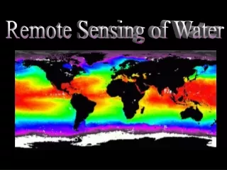
Technology and the Hydrosphere • Remote Sensing - allows scientists to use satellites to monitor all areas of Earth • Hundreds of km above Earth’s surface • Detects changes in light and energy that are not visible to the human eye • Computers can covert to colors Example: temperature
Technology and the Hydrosphere (con’t) • Remote Sensing (con’t) • Uses: • Amounts and location of phytoplankton • Amounts of dissolved organic compounds • Location and amount of sediment • Temperatures (predict El Nino) • Buoys can be used to record temperatures, winds, currents, and air temperatures
Ground Truthing • The information gathered on the GROUND to verify remote-sensing information.
Technology and the Hydrosphere (con’t) • GPS (Global Positioning System) – uses satellites to pinpoint locations on Earth • Calculates latitude and longitude at 3 or more sites Click to picture to see how GPS works
Technology and the Hydrosphere (con’t) • GIS (Geographic Information Systems) – mapmaking software that creates different map layers for the same area • Each layer contains different information • Example: Mapping a Watershed would include different layers, each showing something different like temperature, nitrate levels, pH, dissolved oxygen, pollution • Using all the layers, the location of possible polluters can be determined
Technology and the Hydrosphere (con’t) Click on the image to watch a video about GIS