Download
1 / 22
220 likes | 348 Vues
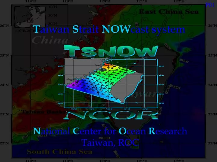
P01. T aiwan S trait NOW cast s ystem. N ational C enter for O cean R esearch Taiwan, ROC. P02. Introduction to NCOR. National Center for Ocean Research (NCOR) was established on August 1, 1997, by the National Science Council of Taiwan. The major missions of NCOR include.

E N D
P01 TaiwanStraitNOWcastsystem National Center for Ocean Research Taiwan, ROC
P02 Introduction to NCOR National Center for Ocean Research (NCOR) was established on August 1, 1997, by the National Science Council of Taiwan. The major missions of NCOR include • promotion of cutting-edge oceanographic research • promotion of the use of satellite remote-sensing technology in oceanographic research • Promotion of international collaboration in oceanographic research • coordination of the use of oceanographic research vessels • establishment of an oceanographic databank
P03 Development of a Nowcast System for the Taiwan Strait (TSNOW) Sen Jan and Yu-Huai Wang National Center for Ocean Research, Taiwan, R.O.C. Shenn-Yu Chao University of Maryland Center for Environmental Sciences, U.S.A. Dong-Ping Wang Marine Science Research Center, SUNY, Stony Brook, U.S.A.
P04 The Taiwan Strait nowcast system • is necessary because 90% of Taiwan’s population, industry and economy lies in her west coast • is based on the extensive hydrographic data acquired in the strait during the past two decades • is aimed for both practical and scientific applications • takes a balanced approach relying equally on models and observations • will have the capacity of real-time observational data assimilation
P05 Nowcast system model domain Matsu Keelung Taipei KY Depression WC Depression Taichung CY Rise Dongshan Kaohsiung Maopitou
P06 Definition of nowcast For TNOW, ”nowcast” is defined as T = 0 T = 24 hrs time sea levels currents
P07 Conceptual model for TSNOW Observations Prediction Demonstration Applications • Short-term • Disaster warning • Marine rescue • Pollutant dispersion • prediction WWW • Long-term • Scientific study • Environmental • policy making • Marine resources • management
P08 Development of the TSNOW system 1st Stage: to establish the capability and demonstrate success in doing good hindcast for the barotropic tides 2nd Stage: to incorporate wind-driven part in the model 3rd Stage: to consider the seasonal/monthly mean circulation and baroclinic effect in the flow field
P09 Observations • To determine initial and boundary conditions • To validate model results Tide-gage stations established by NCOR Tide-gage stations established by CWB Mooring stations of bottom-mount ADCP
P10 Observations Velocities acquired by long-term moored BM-ADCP Velocities measured using SB-ADCP Temperature Salinity Temperature Salinity Spring Summer
P11 Numerical model A 3D general circulation model with free surface is used for the nowcast system. The bottom slope is quite large and the baroclinic effect is strong in the Taiwan Strait, justifying the choice of a z-level model over a sigma-coordinate model (e.g., POM). Five major tidal constituents O1, K1, N2, M2 and S2 were run together in the model. Model resolution Boundary conditions
P12 Determinationof boundary conditions 2D adjoint model assimilating sea levels at 9 tide-gage stations No Observations -- real-time -- near real-time Complex 3D model Malfunction? Boundary conditions Web Yes Transfer function for harmonics derived from larger-domain 2D model
P13 Determinationof boundary conditions Take advantage of a larger-domain 2D tidal model results
P14 Model simulated results
P15 Modelvalidation – sea levels Black-observed Red -calculated Kaohsiung Dongee
P16 Modelvalidation – tidal currents
P17 Modelvalidation – tidal currents Blue - ship-board ADCP measured velocities Red - model calculated velocities Errors of calculated speed: < 40% of measured speed. Errors of calculated current direction: 30º of measured directions.
Tidal Constituents M2 S2 N2 K1 O1 P18 ADJM rms(cm) 6.5 2.2 2.6 3.8 2.0 TSNOW-2D rms(cm) model skill 12.3 0.99 11.5 0.84 2.5 0.98 9.4 0.75 2.5 0.97 TSNOW-ADJM rms(cm) model skill 14.9 0.98 11.4 0.84 4.6 0.94 8.8 0.77 9.2 0.63 Assessmentof model performance Define:
P19 Demonstration of model products Penghu Islands Dongee -24 0 +24
P20 Summary • In the first stage of model development, barotropic tides were successfully simulated in a hindcast mode. • The model performed well as the open boundary conditions were determined using either an adjoint model or a larger-domain two-dimensional model results. • The coexistence of a southward propagating Kelvin wave and a nearly standing wave respectively in the eastern and western halves of the Taiwan Strait has also been examined using the model.
P21 Future work • The two approaches of determining open boundary conditions will be adopted when the model is used in an operational mode. • The wind-driven part, remote-controlled larger-scale circulation and buoyancy-driven circulation will be incorporated in the model step by step. • The observational work will include strait-wide hydrographic surveys, current measurements using bottom-mounted ADCP moorings and real-time sea-level observations.
P22 Thank you for your attention!