Download
1 / 21
250 likes | 458 Vues
Coordinate systems. Geographic Coordinate System. This is a Global Coordinate System Based on angles on the ellipsoidal Earth. latitude positive in n. hemisphere negative in s. hemisphere longitude positive east of Prime Meridian negative west of Prime Meridian. Cartesian Coordinates.

E N D
Geographic Coordinate System • This is a Global Coordinate System • Based on angles on the ellipsoidal Earth • latitude • positive in n. hemisphere • negative in s. hemisphere • longitude • positive east of Prime Meridian • negative west of Prime Meridian
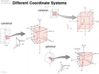
Cartesian Coordinates • Computationally, it is much simpler to work with Cartesian coordinates than with spherical coordinates • x,y coordinates • referred to as “eastings” & “northings” • defined units, e.g. meters, feet • Cartographers hate negative numbers • \
Examples • Common coordinate systems: • Universal Transverse Mercator • Applicable nearly world-wide • Country-wide coordinate systems: • US – the State Plane Coordinate System • UK – Ordnance Survey National Grid
The Universal Transverse Mercator Coordinate System • 60 zones, each 6° longitude wide • zones run from 80° S to 84° N • Coordinates within each zone must be specified • poles covered by Universal Polar System (UPS)
Coordinate systems • Most coordinate systems are tied to projections.
UTM Zone Projection Central meridian Standard lines Transverse Mercator Projection applied to each 6o zone to minimize distortion Transverse Mercator: A cylindrical projection
Projection Aspects cylindrical conical planar
UTM Coordinate Parameters Unit: meters N and S zones: separate coordinates Each zone: 6o longitude wide Y-origin: equator (N zones) near South pole* (S zones) X-origin: 500,000 m west of central meridian * Actually, it’s 10,000,000 meters south of the equator
Universal Transverse Mercator • Each zone looks like this. • North or South must be specified (i.e. we are currently in UTM zone 17N, not just zone 17)
UTM • What do you do when the area of interest crosses UTM zones? • This problem is certain to occur with areas that are wider than 6° of longitude, but on some occasions even a narrower area of interest will happen to be bisected by the edge of a UTM zone • All features need to be encoded using a consistent coordinate system it is customary to assign the coordinates to the more predominant zone that contains the majority of the area of interest
Universal Transverse Mercator Nicaragua
UTM • It is also possibly to encounter an instance when your area of interest crosses the Equator • Northern zone: The Equator’s Northing is at 0m (the Northern zone y-origin is at the Equator) • Southern zone: The Equator’s Northing is at 10,000,000m (the Southern zone y-origin is defined as being 10,000,000m south of the Equator) • Coordinates must be consistent! 0 10,000,000 • The usual solution is to assign all coordinates to the Southern zone
UTM Ecuador
State Plane Coordinate System • The State Plane Coordinate System (SPCS) is only defined and used in the United States • Like UTM, it is divided into zones, but here zones are fully contained within states • Some larger states contain multiple zones • Original units are feet, many states are now switching to meters
Map Projections for State Plane Coordinate System E-W zones: Lambert conformal conic projection N-S zones: Transverse Mercator Projection
4.3 Lambert Conformal Conic (Cont.) Most states that are spread east to west use this projection. The Lambert Conformal Conic projection does not use a single latitude line as its point of contact (a tangent line). Instead, the earth's surface intersects the cone along two lines, called secants. Along these two lines there is no distortion, but distortion does occur as the distance from the secants increases.
4.3 Lambert Conformal Conic (Cont.) Distortion increases as you move away from the secant lines. (ESRI Press)
SPCS • The origin for each zone is placed outside the zone to the southwest (a false origin) • X-origin: • Transverse Mercator (N-S) Zones 500,000 feet west of the furthest point west • Lambert Conformal Conic (E-W) Zones 2,000,000 feet west of the furthest point west • Y-origin is not a specific distance to the south (varies by state and zone)
UTM vs SPCS • SPCS • More accurate than UTM • used primarily for engineering applications, e.g. utility companies, local governments to do accurate surveying of facilities network (sewers, power lines) • Used for small areas • Difficult to use over larger areas (when multiple zones are necessary) • UTM • allows overlap between zones for mapping purposes • The UTM system is global