Download
1 / 40
520 likes | 864 Vues
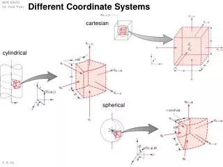
Coordinate Systems. More than X marks the spot. Coordinate Systems. Global – for the Earth Local – applies to you Celestial (Equatorial or Polar) - for the sky Sky Movement Daily Yearly 26,000 years. Altitude and Azimuth Points of reference. Zenith : Straight overhead

E N D
Coordinate Systems More than X marks the spot
Coordinate Systems • Global – for the Earth • Local – applies to you • Celestial (Equatorial or Polar) - for the sky • Sky Movement • Daily • Yearly • 26,000 years
Altitude and AzimuthPoints of reference • Zenith: Straight overhead • Meridian: Line from north to south, passing through the overhead zenith • North: That point on horizon toward the North Pole.
Local Coordinate System Altitude and Azimuth (Alt-Az)Altitude • Angle from the horizon upward. • Measured in degrees from 0 degrees at the horizon to 90 degrees straight overhead at the Zenith. 90º 45º 0º
Altitude and AzimuthAzimuth • Angle measured clockwise from north. • Measured in degrees, from: • 0o north, • 90o east, • 180o south, • 270o west, • back past 359o, to 0o north again
Altitude and AzimuthWhat can you use it for? • Use it for casual references to objects in the sky (e.g. announcements of comet positions). • Use it with alt-az telescope mounts which have digital setting circles that read in alt-az:
Celestial Coordinate SystemRight Ascension and Declination Terms • Celestial sphere: an imaginary sphere, with Earth at the center, having an infinitely large radius. • All stars and celestial objects are projected onto the inside surface of this great sphere.
Right Ascension and Declination • North celestial pole (NCP) and south celestial pole (SCP): where Earth’s polar axis, if extended to the celestial sphere, would intersect. • Celestial equator: a plane from Earth outward to a line around the celestial sphere halfway between the NCP and the SCP. • Ecliptic: the plane in which the Earth orbits the Sun, or the Sun appears to orbit the Earth.
Right Ascension and Declination Declination: • Similar to latitude. • Measured in degrees, perpendicular to the celestial equator (north-south direction). • North is positive, south is negative.
Right Ascension and Declination Right Ascension: • Similar to longitude. • Measured in hours, minutes and seconds around the sky, measured parallel to equator, eastward. • From 0 hr 0 min 0 sec to 23 hr 59 min 59.999… sec.
Right Ascension and DeclinationWhere is the celestial Prime Meridian located and why? • Located at an important spot, where celestial equator and ecliptic cross. • This is where Spring is defined to begin. • Why? In order to keep the calendar consistent with the seasons.
Right Ascension and DeclinationWhere is the celestial Prime Meridian located and why? • Greenwich Royal Observatory • Prime meridian appears in foreground. • Main instrument is a transit telescope • It moves only in altitude. • Installed by George Airy in 1850.
Right Ascension and DeclinationHow can you use it? • Knowing the coordinates of an object you want to see, from a star catalogue…
Right Ascension and DeclinationHow can you use it? • Locate the object at the coordinates on the star chart…
Right Ascension and DeclinationHow can you use it? • From the star chart, pick out recognizable constellation or star patterns in the area, and pick out marker stars to the object.
Right Ascension and DeclinationHow can you use it? • Now find a similar star pattern in the sky…
Right Ascension and DeclinationHow can you use it? • And follow the imaginary lines you mentally drew on the star chart.
Zenith Meridian Polaris (NCP) The declination of my zenith is equal to my latitude! MPHMPHMPH WEST SOUTH NORTH EAST
Declination and location Declination of zenith = latitude AND… Latitude = angle of Polaris above northern horizon
Sky Movement - DailySolar Day & Sidereal Day • In a 24 hour solar day, last night’s star arrives at tonight’s meridian 3 min 55.9 seconds earlier than last night. • Stars cross the meridian 3 m 55.9 s earlier each night. • Sidereal day is 23 hr 56 min 4.1 sec long.
Sky Movement - Annual • As a consequence, each night the stars appear about 59 arc-min (~10) farther west at the same time as the night before. • Over one year, the entire sky will completely slip past. • Therefore, what is up tonight depends not only on what time of night it is, but on which night of the year it is. Last month’s stars are 2 hours farther west.
Sky Movement - Annual Manage both: • time of night, and • night of the year with a Planisphere.
Using your star wheel • Set date and time • Hold overhead • Align horizons • Read constellations
Sky Movement – 26,000 years • The Roman calendar, as established by Julius Caesar, had problems: • Started at Winter Solstice on January 1, 45 BC. • Year was 365 ¼ days long, with leap year corrections. Decimals had not been invented yet; • Year is actually 365.242199… days. • So, after a few centuries, people noticed the seasons (equinoxes) were moving slowly in relationship to their calendar.
Precession of the Equinoxes • Earth’s drifting polar axis causes the North Celestial Pole to move in a circle around the sky, once every 26,000 years. • Thuban was the pole star when the Great Pyramid was built in Egypt.
Leap Years • Gregorian solar year: 365d 5h 48m 20s; still has 25.967s/SY error. • Summer solstice moves later on calendar each year. Slightly over-corrected each leap year. • Cumulative annual error is corrected each century by not having a leap year, unless that year is divisible by 400 (1600 and 2000 were leap years).
Why bother with such tedious accuracy ? • Nearly all major advances in astronomy occurred when observation did not agree with prediction, and people needed a better theory for better predictions. • Astronomy advanced as instruments became precise enough to measure the flaw in prevailing theory. • By the middle of the 19th Century we could predict the movement of stars and planets within a fraction of a second, except….
What does this lead up to? • The perihelion of Mercury (point closest to the Sun) was observed to be advancing in longitude by about half a minute of arc per century faster than prevailing celestial mechanics predicted. • Which is where Newtonian Theory ends, and Relativity Theory begins. • Scientific advancement is a journey, not a destination. Our trip continues with each new discovery.
Web Stuff http://astro.unl.edu/classaction/coordsmotion.html
Credits: Books • All About Telescopes, Edmund Scientific, 1975 • Calendar, David Ewing Duncan, 1998 • Cambridge Illustrated History of Astronomy, Michael Hoskins, ed., 1997 • Instruction Manual, Meade Instruments Corp, 1996 • Observer’s Handbook 2005, RASC, 2004 • Sky 2000.0, Will Tirion, 1981 • The Practical Astronomer, Colin a Ronan, 1984
Credits: Web sites For magnetic declination for any latitude and longitude: http://www.geolab.nrcan.gc.ca/results/mirp_result.70.241.78.92_e.shtml For seasons and ecliptic tilt: http://en.wikipedia.org/wiki/Season For history of Royal Observatory at Greenwich: http://www.nmm.ac.uk/