Download
1 / 27
270 likes | 395 Vues
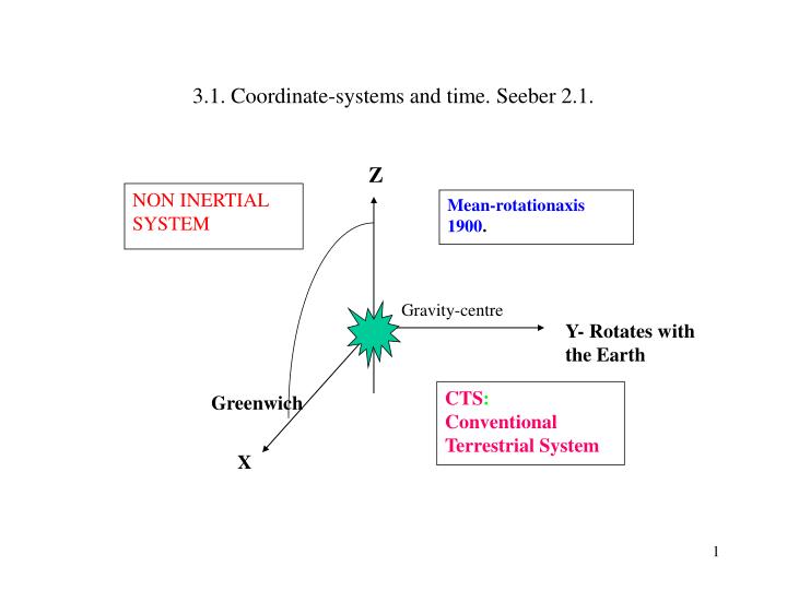
3.1. Coordinate-systems and time. Seeber 2.1. Z. NON INERTIAL SYSTEM. Mean-rotationaxis 1900. Gravity-centre. Y- Rotates with the Earth. CTS : Conventional Terrestrial System. Greenwich. X. CIS.

E N D
3.1. Coordinate-systems and time. Seeber 2.1. Z NON INERTIAL SYSTEM Mean-rotationaxis 1900. Gravity-centre Y- Rotates with the Earth CTS: Conventional Terrestrial System Greenwich X
CIS • Zero-meridian for Bureau Internationale de l’ Heure (BHI) determined so that star-catalogues agree in the mean with observations from astronomical observatories. • The connection to an Inertial System is determined using knowledge of the Z-axís (Polar motion), rotational velocity and the movement of the Earth Center. • We obtain an Quasi-Inertial system, CIS. • More correct to use the Sun or the centre of our galaxe !
Kap. 3 POLAR MOTION • Approximatively circular • Period 430 days (Chandler period) • Main reason: Axis of Inertia does not co-inside with axis of rotation. • Rigid Earth: 305 days: Euler-period.
Kap. 3 POLAR MOVEMENT • Coordinates for the Polen and Rotational velocity • IERS (http://www.iers.org) • International Earth Rotation and Reference System service (IAG + IAU) • http://aiuws.unibe.ch/code/erp_pp.gif • Metods: VLBI (Radio astronomi) LLR (Laser ranging to the Moon) SLR (Satellite Laser ranging) GPS, DORIS
Kap. 3 • Polbevægelse, 1994-1997, Fuld linie : middel pol bevægelse, 1900-1996
Kap. 3. International Terrestrial Reference System (ITRS) • Defined, realised and controlled by IERS ITRS Center. http://www.iers.org/iers/products/itrs/ • Geocentric, mass-centre from total Earth inclusive oceans and atmosphere. • IERS Reference Pole (IRP) and Reference Meridian (IRM) konsist with BIH directions within +/- 0.005".
Kap. 3, ITRS. • Time-wise change of the orientations secured through 0-rotation-condition taking into account horizontal tectonic movements for the whole Earth. • ITRS realised from estimate of coordinates for set of station with observations of VLBI, LLR, GPS, SLR, and DORIS. See: ftp://lareg.ensg.ign.fr/pub/itrf/old/itrf92.ssc
Kap. 3 • Paris, 1 July 2003 Bulletin C 26 • INFORMATION ON UTC - TAI • NO positive leap second will be introduced at the end of December 2003. • The difference between UTC and the International Atomic Time TAI is : • from 1999 January 1, 0h UTC, until further notice : UTC-TAI = -32 s • Leap seconds can be introduced in UTC at the end of the months of December or June, depending on the evolution of UT1-TAI. Bulletin C is mailed every six months, either to announce a time step in UTC, or to confirm that there will be no time step at the next possible date. • http://www.iers.org/iers/products/eop/leap_second.html
Ch. 3, Transformation CIS - CTS • Precession • Nutation • Rotation+ • Polar movement Sun+Moon
Ch. 3, Precession. • Example: t-t0=0.01 (2001-01-01) • .
Ch. 3, Nutation – primarily related to the Moon. • Movement takes place in Ecliptica
Ch. 3, Nutation: • .
Ch. 3, Example for point on Equator. • Suppose θ=0, xp=yp =1” (30 m) • .
Ch. 3, Exercise. 2 May 1994: x”=0.1843”=0.000000893, y”=0.3309”=0.0000014651 (x,y,z)=(3513648.63m,778953.56m,5248202.81m) Compute changes to coordinates.
Ch. 3, Time requirement • 1 cm at Equator is 2*10-5 s in rotation • 1 cm in satellite movement is 10-6 s • 1 cm in distance measurement is 3*10-11 s • We must measure better than these quantities. • Not absolute, but time-differences.
Ch. 3, Siderial time and UT. (see fig. 2.13). • Siderial time: Hour-angle of vernal equinox in relationship to the observing instrument • LAST: Local apparent siderial time: true hour angle • GAST: LAST for Greenwich • LMST: Local hour angle of mean equinox • GMST: LMST for Greenwich • GMST-GAST=Δψcosε • LMST-GMST=LAST-GAST=Λ xp
Ch. 3, UT • UT= 12 hours + Greenwich hourangle for the mean sun. Follows siderial time. • 1 mean siderial day = 1 mean solar day -3m55.909s. • UT0B is time at observation point B, must be referred to conventional pole • UT1= UT0B + ΔΛP
Ch. 3, Dynamic time • ET: Ephemeis time (1952) to make equatins of motion OK. • TDB= Barycentric time – refers to the Sun • TDT=Terrestrial time • From general relativity: clock at the earth moving around the sun varies 0.0016 s due to change in potential of sun (Earth does not move with constant velocity). • TDB=ET on 1984-01-01
Ch. 3, GPS Time • GPS time = UTC 1980-01-05 • Determined from Clocks in GPS satellites • GPS time – UTC = n * s-C0, • C0 about 300 ns
Ch. 3, Clocks and frequency standards. • With GPS we count cycles. Expect the fequency to be constant.
Ch. 3, Praxis, see Seeber, Fig. 2.15. • Precision quarts crystal: temperature dependent, aging • Rubidium: good stability, long term • Cesium: stable both on short term and long term – transportable, commercially available. • Hydrogen masers: 10-15 stability in periods of 102 to 105 s. • Pulsars: period e.g. 1.6 ms.