Download
1 / 26
260 likes | 419 Vues
Sharing Hydrologic Data with the CUAHSI Hydrologic Information System. David Tarboton , David Maidment , Ilya Zaslavsky , Dan Ames, Jon Goodall , Jeffery Horsburgh , Tim Whiteaker , Michael Piasecki , David Valentine, Tom Whitenack , Kim Schreuders. http://his.cuahsi.org/. CUAHSI HIS

E N D
Sharing Hydrologic Data with the CUAHSI Hydrologic Information System David Tarboton, David Maidment, IlyaZaslavsky, Dan Ames, Jon Goodall, Jeffery Horsburgh, Tim Whiteaker, Michael Piasecki, David Valentine, Tom Whitenack, Kim Schreuders http://his.cuahsi.org/ CUAHSI HIS Sharing hydrologic data Support EAR 0622374
Consortium of Universities for the Advancement of Hydrologic Science, Inc. • 110 US University members • 6 affiliate members • 12 International affiliate members • (as of March 2009) An organization representing more than one hundred United States universities, receives support from the National Science Foundation to develop infrastructure and services for the advancement of hydrologic science and education in the U.S. http://www.cuahsi.org/
Goal A system that enhances access to hydrologic data for education and research to better understand hydrologic processes. • How can we better organize hydrologic data to enhance the analysis it can support? • How can we better provide access to the data sources, tools and models that enable the synthesis, visualization and evaluation of the behavior of hydrologic systems? Water quantity Water quality Precipitation Meteorology
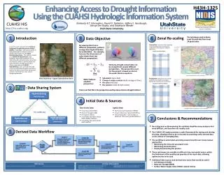
CUAHSI HIS The CUAHSI Hydrologic Information System (HIS) is an internet based system to support the sharing of hydrologic data. It is comprised of hydrologic databases and servers connected through web services as well as software for data publication, discovery and access. Data Discovery and Integration platform HIS Central Like search portals Google, Yahoo, Bing Metadata Search Metadata Services Service and data theme metadata Service registration Data carts Catalog harvesting Data Services HydroServer HydroDesktop Data Synthesis and Research platform Data Publication platform Water Data Services Spatial Data Services Like HTML Like web servers Like browsers
CUAHSI Water Data Services System Base Station Computer(s) Telemetry Network Sensors Platform independent Analysis Discovery and Access Query, Visualize, and Edit data using ODM Tools Hydro Desktop HydroExcel GIS Matlab Splus R IDL Java C++ VB ODM Database Service Registry Hydrotagger WaterML Streaming Data Loader GetSites GetSiteInfo GetVariableInfo GetValues Excel, text HIS Central Harvester USGS NWIS Water Metadata Catalog WaterOneFlow Web Service ODM Data Loader EPA STORET NCDC Others
Set of query functions ReturnsdatainWaterML WaterML and WaterOneFlow WaterML is an XML language for communicating water data WaterOneFlow is a set of web services based on WaterML Slide from David Valentine
GetValues GetVariables qualifier ISO Time value
What are the basic attributes to be associated with hydrologic data values and how can these best be organized? Groundwater levels Streamflow Precipitation & Climate Soil moisture data Flux tower data Water Quality
“When” Time, T t A data value vi (s,t) “Where” s Space, S Vi “What” Variables, V Observations Data Model (ODM) – a relational model at the single observation level • Stores observation data made at points • Metadata for unambiguous interpretation • Traceable heritage from raw measurements to usable information • Standard format for data sharing • Cross dimension retrieval and analysis
CUAHSI Observations Data Model http://his.cuahsi.org/odmdatabases.html Horsburgh, J. S., D. G. Tarboton, D. R. Maidment and I. Zaslavsky, (2008), A Relational Model for Environmental and Water Resources Data, Water Resour. Res., 44: W05406, doi:10.1029/2007WR006392.
Loading data into ODM ODM Data Loader • Interactive ODM Data Loader • Loads data from spreadsheets and comma separated tables in simple format • Streaming Data Loader (SDL) • Loads data from datalogger files on a prescribed schedule • Interactive configuration • SQL Server Integration Services (SSIS) • Microsoft application accompanying SQL Server useful for programming complex loading or data management functions SDL SSIS
Dynamic controlled vocabulary moderation system ODM Data Manager ODM Website ODM Tools ODM Controlled Vocabulary Moderator XML Master ODM Controlled Vocabulary Local ODM Database ODM Controlled Vocabulary Web Services Local Server http://his.cuahsi.org/mastercvreg.html From Jeff Horsburgh
HIS Central • Publishers • Register a data service • Users • Find a data service • Supported by • Metadata Catalog http://hiscentral.cuahsi.org
HydroTagger Each Variable in your data is connected to a corresponding Concept
Map Server Time Series Analyst HydroServerWebsite HydroServerCapabilities Web Service HydroServerDatabase Configuration Tool WaterOneFlow Services HydroServer Database Spatial Services WaterOneFlow WaterOneFlow WaterOneFlow ODM ODM ODM ODM Databases and WaterOneFlow Web Services ArcGIS Server Spatial Data Services
HydroDesktopHarvesting and analyzing data from web services GIS Hydrology • Add shapefiles to map • Change symbology and labels • Print and export map • GIS toolbox • Search for data • Download data • Display time series • Export data http://hydrodesktop.codeplex.com
HydroDesktop • Platform for data discovery, access, integration and analysis • Uses MapWindow 6 open source GIS software development toolkit • Plug-in architecture (extendibility that enables customization) • Data abstraction layer • http://hydrodesktop.codeplex.com open source software development portal • Windows and Mac compatible (through Mono) Observations GIS Models Climate Remote Sensing
CUAHSI Water Data Services 43 services 15,000 variables 1.8 million sites 9 million series 4.3 billion data
NCDC Integrated Station Hourly Data Hourly weather data up to 36 hours ago 13,628 sites across globe 34 variables Published by National Climate Data Center and populated with weather observations from national weather services http://water.sdsc.edu/wateroneflow/NCDC/ISH_1_0.asmx?WSDL
USGS Instantaneous Data Real time, instantaneous data over the last 60 days 11188 sites, nationally for the US 80 variables Published by USGS National Water Information System
Reynolds Creek Experimental Watershed 1 data service 84 sites 65 variables 372 series 17.8 million data Published by USDA-ARS as part of an Idaho Waters project http://idahowaters.uidaho.edu/RCEW_ODWS/cuahsi_1_0.asmx?WSDL
Dry Creek Experimental Watershed (DCEW) (28 km2 semi-arid steep topography, Boise Front) 68 Sites 20 Variables 5924511 values Published by Jim McNamara, Boise State University http://icewater.boisestate.edu/dcew2dataservices/cuahsi_1_0.asmx?WSDL
Advancement of water science is critically dependent on integration of waterinformation Databases: Structured data sets to facilitate data integrity and effective sharing and analysis. - Standards - Metadata - Unambiguous interpretation Analysis: Tools to provide windows into the database to support visualization, queries, analysis, and data driven discovery. Models: Numerical implementations of hydrologic theory to integrate process understanding, test hypotheses and provide hydrologic forecasts. Models ODM Web Services Databases Analysis
Conclusions • Data Storage in an Observations Data Model (ODM) • Data Access through internet-based Water Data Services using a consistent data language, called WaterML • Data Indexing through a National Water Metadata Catalog • Data Discovery through federated map and thematic keyword search system The combination of these capabilities creates a common window on water observations data for the United States unlike any that has existed before.