Download
1 / 20
200 likes | 205 Vues
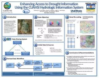
CUAHSI Hydrologic Information System (HIS) provides web services, tools, and standards to enhance access to hydrologic data for analysis. Publish spatial datasets, access data, query, visualize, and edit data using various tools and languages.

E N D
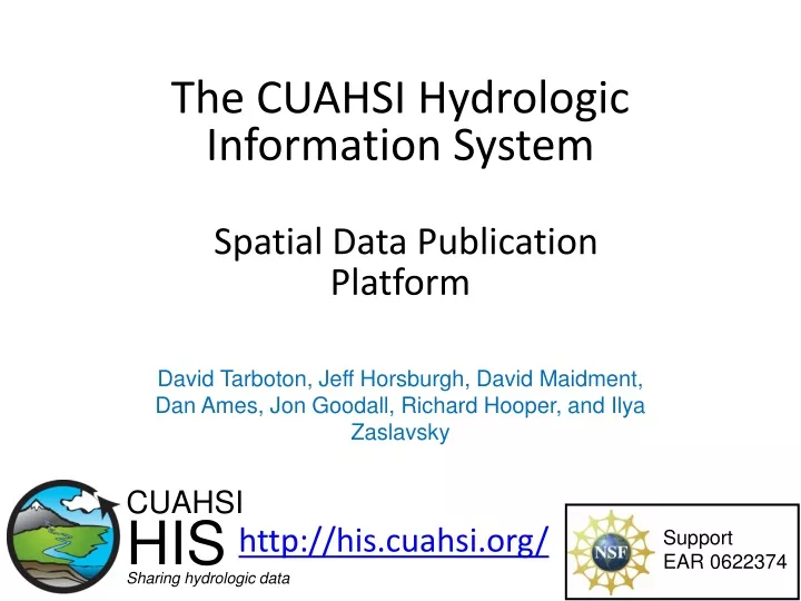
The CUAHSI Hydrologic Information SystemSpatial Data Publication Platform http://his.cuahsi.org/ David Tarboton, Jeff Horsburgh, David Maidment, Dan Ames, Jon Goodall, Richard Hooper, and Ilya Zaslavsky CUAHSI HIS Sharing hydrologic data Support EAR 0622374
What is HIS • The CUAHSI Hydrologic Information System (HIS) provides web services, tools, standards and procedures that enhance access to more and better data for hydrologic analysis. http://his.cuahsi.org Water quantity Water quality Precipitation Meteorology
Services-Oriented Architecture for Water Data Search engines Google, Yahoo Browsers, Mosaic, Firefox Web servers
Base Station Computer(s) Telemetry Network Sensors CUAHSI Water Data Services System Discovery Analysis Access Query, Visualize, and Edit data using ODM Tools Hydroseek GIS Matlab Splus R IDL HIS Desktop HydroExcel Java C++ VB ODM Database Service Registry Hydrotagger WaterML Streaming Data Loader GetSites GetSiteInfo GetVariableInfo GetValues Excel, text HIS Central Harvester USGS NWIS Water Metadata Catalog WaterOneFlow Web Service ODM Data Loader EPA STORET NCDC Others
CUAHSI WaterOneFlow Web Services“Getting the Browser Out of the Way” GetSites GetSiteInfo GetVariableInfo GetValues Standard protocols provide platform independent data access WaterML SQL Queries Data Consumer ODM Database Query Response
Set of query functions ReturnsdatainWaterML WaterML and WaterOneFlow WaterML is an XML language for communicating water data WaterOneFlow is a set of web services based on WaterML Slide from David Valentine
“When” Time, T t A data value vi (s,t) “Where” s Space, S Vi “What” Variables, V What are the basic attributes to be associated with each single data value and how can these best be organized? • Observations Data Model (ODM) • A relational database at the single observation level (atomic model) • Stores observation data made at points • Metadata for unambiguous interpretation • Traceable heritage from raw measurements to usable information • Standard format for data sharing • Cross dimension retrieval and analysis
Point Observations Data Internet Applications Ongoing Data Collection Historical Data Files ODM Database GetSites GetSiteInfo GetVariableInfo GetValues GIS Data WaterML WaterOneFlow Web Service Data presentation, visualization, and analysis through Internet enabled applications HIS Server
HIS Server • Point data, time series (ODM) • Map server (ArcGIS server) • Spatial data services (grids, fields, features) • OGC WFS, WCS, WMS • Data node capabilities web service • ODM and map service catalogs • service level metadata listings • WaterOneFlow web services • ODM Suite (Loader, SDL, Tools) • Time series analyst (web application) • HIS Server website 2008 New Spatial data publication platform
Map Server Time Series Analyst HIS Server Website HIS Server Capabilities Web Service HIS Server Database Configuration Tool WaterOneFlow Services HIS Server Database Spatial Services WaterOneFlow WaterOneFlow WaterOneFlow ODM ODM ODM ODM Databases and WaterOneFlow Web Services ArcGIS Server Spatial Data Services
Publication of Spatial (GIS) Datasets • Publishing spatial datasets using ArcGIS Server • Using OGC standards that can be consumed by a number of GIS clients • WMS, WFS, WCS
Data Presentation Via a Map Interface • Internet Map Server built using ArcGIS • Web browser client • Combine spatial data and observational data • Launch data visualization tools • Based on a “Region” http://maps.usu.edu/map/
Data Preview, Visualization, and Analysis • Time Series Analyst • Web Browser Client • Multiple ODM Database Support • Variety of plot types and descriptive statistics • Linked to the map server application • Enables data preview and download http://tsa.usu.edu/odmanalyst/
HIS ServerWebsite • HIS Server description page • Listing of published observational data services • Listing of published GIS data services • Links to the map server and Time Series Analyst • Data Query and Download Page http://littlebearriver.usu.edu
HydroServer Capabilities Web Service • Publish capabilities of each HydroServer • Listing of published observational data services • Listing of published spatial data services • Supports automatic cataloging of available services at HIS Central • Makes HydroServers self describing
Conclusions • HIS Server provides a self contained autonomous data publication system • Local control of data • Spatial and map data services (OGC via ArcGIS Server) • Downloadable user (data publisher) configurable software stack that contains: • ODM and associated tools • WaterOneFlow web services version 1.1 • Geographic data sharing using WFS, WCS from ArcGIS server • Time series analyst • Generic ArcGIS server based web map application • Data node capabilities web services that publish metadata on time series and spatial data services
HIS Server Future Considerations • Security and authentication • More generic object structure • Flexibility in attributes • moving platforms • Additional data types • Tighter integration with Ontology • Enhanced spatial data sharing What features and functionality does HIS Server need to better serve the communities needs with respect to NEXRAD specifically, and for any other data?
Reports • 2008 status report summarizes the conceptual framework, methodology, and application tools for HIS • Shows how to develop and publish a CUAHSI Water Data Service • 2009 status report details the expansions and updates http://his.cuahsi.org/documents/HISOverview2009.pdf