Chap 12 Coasts
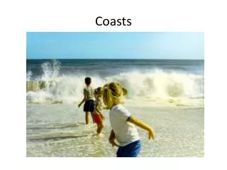
Chap 12 Coasts. The Coast. Is the area of a continent or island that is affected by the adjacent ocean or sea. These areas are affected by the tide, storms that come from the sea, and the moderating influence of the ocean. The coast can extend several 10s of kilometers inland. .

Chap 12 Coasts
E N D
Presentation Transcript
The Coast • Is the area of a continent or island that is affected by the adjacent ocean or sea. • These areas are affected by the tide, storms that come from the sea, and the moderating influence of the ocean. • The coast can extend several 10s of kilometers inland.
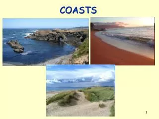
The shore is the area where the sea meets the land, and is generally less than 1 km wide. • The shore is either a rocky area or a sandy beach.
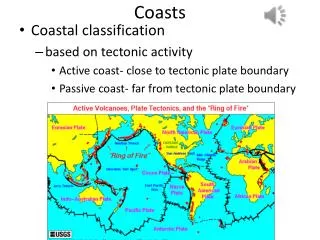
Classifying the Coast • One way of classifying the coast is according to tectonic position • 1. Active coast – near the leading edge of moving continental plates • 2. Passive coast – trailing the edges of the plates • Sea level changes are important in classification of coastal areas
The most popular classification combines both elements • This divides the coastal areas in: • 1. Primary coast – young coast with terrestrial influence, stable since the last ice ages, retain evidence of the process that produce it • 2. Secondary coast – older than primary and has been significantly changed since the last changes in sea level, little is any evidence of the process that produce them
Primary Coast • Characteristics: • 1. Rough and irregular • 2. Features of activities like scouring of glaciers, deposition of sediment, and volcanic activity are present
Rivers empty into the sea through a mouth which may have one of 2 shapes: • 1. the river mouth is extended into the sea as a delta. (triangular)(f.12.4) • 2. the river mouth is cut back into land as an estuary or fjord (pronounce the 'j' as a 'y'). ( f.12.3) • The principle difference between the two main shapes is how much sediment the river is carrying.
Estuaries were once valleys carved out by rivers during the last glacial maximum. • Since sea level has risen over the last 18,000 years, these river valleys became drowned. • Fjords are a type of estuary that was carved by glaciers during the last glacial maximum. • Since sea level rise, these glacial valleys became drowned.
For a delta to maintain its size or grow, the river must carry enough sediments to keep marine process in check • The combined effects of waves, tides and river flow determines the shape of the delta • Fig 12.6 shows the classification of deltas according to this factors
Volcanic Coast • Coast of volcanic island will consist of lobed lave flows extending seaward • Concave may also occur when a small volcano explodes or collapses and fills with seawater (f. 12.8)
Earth Movement • Coast can coincide with plate boundaries • If the crust moves downward, it creates a steep escarpment • If the crust moves upward, it exposes a previously submerged area (f.12.9)
In general, these are areas of erosion, and many of the features we see at rocky coasts are formed by waves eroding the uplifted rocks. • There are 4 features caused by erosion at rocky shores ( f. 12.12): • sea stacks - isolated pillars of rock left standing after all the rock around it has been eroded away • arches - rocks from which the bottom has been eroded away by waves
3. blowholes - cracks and crevices in rocky coasts through which wave water is forced upward 4. wave-cut platforms and -notches - the notches are cut-outs at the base of a rocky cliff; the platforms are flat-lying areas • The rocky part of land sticking out toward sea is called a headland. • The indentation into land where sand can accumulate on a beach is called a cove beach.
Below is a sea stack and an arch. These features are caused by wave erosion.
Pounding waves can erode cracks and crevices into rocky cliffs. • When waves break at the base of these cliffs, the water is forced up into the cracks, forming blowholes.
Here is a wave-cut notch (the indentation at the base of the cliff) and the flat-lying wave-cut platform at the base of the cliff, above the waves. • Both indicate that sea level in this area was higher, and have since been uplifted by tectonic or isostatic activity.
Beaches • The principle feature of a sandy shore is the beach (f. 12.15). • Zone of unconsolidated particles that cover part or all of the shore • A typical sandy beach has a number of features, some of which are formed by deposition, and some by erosion.
Agents of deposition include: • the wind (on land) • waves • longshore currents • tidal currents
If you slice a beach, like a giant slice of cake, the following profile would appear (f. 12.16) • 1. The Backshore is usually above water except during big storms or unusually high tides.
Agents of deposition include: • the wind (on land) • waves • longshore currents • tidal currents
If you slice a beach, like a giant slice of cake, the following profile would appear (f. 12.16) • 1. The Backshore is usually above water except during big storms or unusually high tides.
a high-standing area that is either a sea cliff (rocky shores) or a set of sand dunes • sand dunes are deposited by the wind and are usually in motion (shifting sands) • The dunes are important areas for sand storage
A flat area called the berm, a good place to lay your beach towel because it is usually above water except when there is a storm or very high tide • The Foreshore area, which is where all the wave action takes place
Note the foreshore area is underwater at high tide, and above water at low tide. • This is a tough environment to adapt to. • The Offshore area, which is underwater all of the time, and also below wave base most of the time (except during big storms). • This is where longshore currents move sand around, forming longshore bars.
If you climb the sand dunes (don't! they are usually vegetated with a beautiful grass, which are protected by law) or the sea cliff, and keep heading away from the ocean, you are heading landward.
The beach profile varies from season to season. • In general, there is more deposition, and a smoother profile during the summer when waves are gentle and big storms are scarce. • Conversely, there tends to be more erosion in the winter when many large storms lash the coast with big waves.
Longshore currents (12.21-22) are local currents that are largely generated by waves that strike the shore at some angle (not parallel). • This pushes the water into a current that parallels the shoreline, the longshore current. • Longshore currents are important movers of sand at the shore. • They are one of the causes of sediment drift, which is the constant motion of sand grains parallel to the shore.
Rip Currents • Another effect of waves striking the shore at an angle is that water can be piled up on the beach (12.19) • This is particularly likely after a big storm and big waves have brought lots of water to the beach. • The pile of water flows back to the ocean in a fairly narrow (10s of feet wide) and strong current, the rip current.
It usually flows between longshore bars. • Sometimes rip currents are visible as a patch of muddy water (they're carrying sediment in that case), but often they are not visible to swimmers. • If you feel yourself moving seaward faster than you would like, don't panic! • Swim parallel to shore and you eventually get out of the current.
Estuaries • Estuaries are environments similar to that of a lagoon, particularly with regards to salinity • This is a curious place, where freshwater meets the ocean, and a peculiar type of water circulation occurs here called 'estuarine circulation‘ • Freshwater from the river flows out into the estuary, and being less dense than seawater, floats on top of the seawater.
The outgoing river water drags the underlying seawater with it, and this causes seawater to flow into the estuary, up to a point ( f.12.30) • This results in a stratified estuary, with little mixing of the overlying fresh- and the underlying salt waters. • The point to which the salt water wedge flows (hand below) is the same point at which the river water loses contact with the river bottom.
At this point sediment from the river is deposited, and any sediment from the sea water is also deposited. • In places where the tide is vigorous, the fresh- and salt waters are mixed by internal waves. This results in no stratification, and a mixed estuary. • Estuaries are also good places to anchor a ship, since wave energy is minimized.
Along our east coast, most of the cities in existence by the time of the Revolution were built along estuaries: • Charleston, Richmond, Philadelphia, Savannah, Baltimore, Newport... • Millions of people live around estuaries, and this puts a lot of pressure on these ecosystems.
Human Activities • 1. Construction of dams reduces river sediment inflows. • 2. Extraction of sediments from rivers alters the sediment inflows. • 3. Extraction of fossil fuels and water causes subsidence.