Download
1 / 17
170 likes | 466 Vues
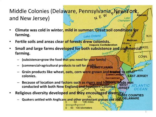
Coastal Geography of New Jersey and New York. By: Sarah Aimone & Lori Czaplinski. THE JERSEY COAST 130 miles of open ocean coastline 1792 miles of tidally affected land 60% of shoreline is Barrier islands 70% of states population lives within coastal counties. Major Bays and Rivers

E N D
Coastal Geography of New Jersey and New York By: Sarah Aimone & Lori Czaplinski
THE JERSEY COAST • 130 miles of open ocean coastline • 1792 miles of tidally affected land • 60% of shoreline is Barrier islands • 70% of states population lives within coastal counties
Major Bays and Rivers • Hudson Bay • Barnegat Bay • Great Bay • Delaware Bay • Raritan Bay • Hudson River • Delaware River
Barrier islands of NJ • Eight barrier islands Long Beach Island, Brigantine Island, Absecon Island, Peck Beach Island, Ludlam Beach Island, Little Beach Island, Seven Mile Beach Island, Five Mile Beach Island. • Two peninsulas that act like Barrier islands Barnegat Bay Peninsula Sandy Hook Peninsula
Erosion of the Shoreline • 26 % of New Jersey shoreline is critically eroding • Large scale, statewide beach nourishment program • The Sandy Hook to Barnegat Inlet project largest beach fill project in world (in terms of volume) • Seawalls
Tidal range • Sandy hook 0.69 ft – 5.61 ft • Atlantic City 1.06ft- 6.25 ft
New York125 miles of open ocean coastline>5,000 miles of shoreline, including the Great Lakes1,850 miles of tidally affected land70% of the state’s population lives within coastal counties (13,800,000)
Major Rivers, Bays and Lakes: St. Lawrence River, Hudson River Lake Ontario, Lake Erie, Lake Champlain Hudson Bay, Long Island Sound
Long Island • Long Island extends east of New York City • Flanked by the Long Island Sound and the Atlantic Ocean • 125 miles of ocean coast • Four barrier islands are located off the south shore • Several inlets and bays
Barrier Islands:Long Beach IslandJones Beach IslandFire Islandthe Unnamed Island
Long Beach Island:-10 ¼ miles of ocean beach-extensive salt water marsh-important rest stop for migratory waterfowlJones Beach Island:-19 miles of ocean front-1000 acres of wetlands-state parks used for recreationFire Island:-largest in the chain; 32 miles of ocean beach-30% marsh-Fire Island National Seashore-Moriches flatsUnnamed Island:-19 ¾ miles ocean front-connected to LI Peninsula until a hurricane in 1938 opened up Shinnecock Inlet
Beach Erosionand Nourishment • 47 % of the shoreline is critically eroding • Human activity??? The coastline is very densely populated! • Private property owners allowed to protect/nourish their land • Numerous groins on Long Island and Staten Island
Tidal Range • Montauk 0.64-2.95 ft • The Battery 1.71-6.24 ft
New York Bight-great expanse of shallow ocean between Long Island and the New Jersey Coast-Longshore transport of sand by wave action from the southeast, ultimately from prevailing wind zones and storm events in the tropics and the South Atlantic region. Hurricanes during the summer and nor'easters during the winter are responsible for intense periods of sediment transport and beach erosion and accumulation.
References • Scheinkman, J.J. and P.M. Byrne. Inventory of the Barrier Island Chain of the States of New York and New Jersey. New York: The Mc Intosh Foundation 1977. • http://surfrider.org • http://noaa.gov • www.geo.hunter.cuny.edu • http://marine.rutgers.edu/geomorph • www.worldatlas.com • www.thejerseyshorepartnership.com