Download
1 / 26
260 likes | 649 Vues
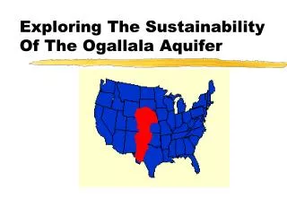
Exploring The Sustainability Of The Ogallala Aquifer. Erin O’Brien Biological & Agricultural Engineering National Science Foundation - Research Experience for Undergraduates McNair Scholar’s Program Kansas State University Summer 2001. Introduction.

E N D
Exploring The Sustainability Of The Ogallala Aquifer Erin O’Brien Biological & Agricultural Engineering National Science Foundation - Research Experience for Undergraduates McNair Scholar’s Program Kansas State University Summer 2001
Introduction • The Ogallala aquifer lies within the Great Plains region. • This groundwater source is a part of the High Plains aquifer system. • In Kansas the High Plains aquifer system and the Ogallala aquifer are typically the same.
Western Kansas is a major economic source for Kansas: • 40% of the nation’s packaged beef comes from within 250 miles of Garden City, and • Kansas is 2nd in the nation in cattle slaughter and 3rd for red meat production.
“Meeting fundamental human needs while preserving the life-support systems of planet Earth is the essence of sustainable development.” —(Kates, et al. 2001) • Since irrigation from the Ogallala taps ‘fossil’ groundwater there is an issue of sustainability of the current system.
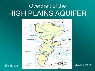
Study Area • My study looked at the High Plains with a focus on SW Kansas. • The Ogallala aquifer: • Underlies 134,000 mi2, • Is the largest body of groundwater in the U.S. • The porous rock layers were formed ~10 million years ago by fluvial deposition.
The High Plains aquifer has 3.25 billion ac-ft of water, approximately equivalent to Lake Huron. • 30% of the water used for irrigation in the U.S. comes from the High Plains aquifer. • 10% percent of the drainable water in the High Plains aquifer underlies Kansas.
The High Plains aquifer faces many different concerns, including purity, quality, quantity, and saturated thickness. • The Ogallala region has many concerns: • ~19% is covered by sand dunes; • Water consumption is 10-40 times recharge • Local precipitation does not affect recharge
Ogallala facts: • Only 15-20% of the water is available for withdrawal and only 60-80% of this is technologically accessible. • KGS scientists say it may take 35 years for recharge water to reach the aquifer. • The water in the Ogallala is fossil water and is only available through groundwater mining.
History • The droughts of the 1930s and 50s made people realize that the climate changes of the region were simply cyclical variations. • Irrigation rapidly expanded following the drought of the 1950s. • By 1972, ~40% of the available groundwater had been consumed.
Technology • In 1896 in Garden City, KS, a centrifugal pump was one of the first attempts at irrigation in Kansas. • Another pump was in use by 1911 in Scott City, KS. • In 1949, center-pivot systems were developed. • Drop tubes & subsurface drip irrigation (SDI) have become common recently.
Rules/Regulations • In 1972 KS passed the GMD Act to: • Regulate groundwater, • Grant drilling permits, and • Ensure old water rights are protected. • Constraints exist on policies that would decrease water availability. Adjustments must be technically, financially, legally, and socially feasible.
Sustainability Issues • Farmers irrigate for many reasons: • To meet a specific crop need; • To increase yearly income; • As a result of success by other irrigators; and • To maintain their water rights. • The number of irrigated acres is declining in all states. • Irrigation offers a climate substitute and enables increased yields.
Top: Feedlot at Dodge City, KS. Left: Sign for IBP, a packing plant near Garden City, KS.
Recurrent droughts are a hazard for the region. • There were two prolonged droughts in the last century: • In the 1930s and the 1950s. • What will happen when the water is gone? • Two New Jersey scholars have proposed a “buffalo commons” national park.
The area has already been affected by a decreased flow in the Arkansas River due to diversion and pumping. • It has only recently began to flow again, after a Supreme Court ruling limited withdrawals.
These pages show graphs indicating: • Predevelopment saturated thickness, • Current saturated thickness, • The amount of groundwater depletion, and • The number of years of usage remaining. --Schloss, et al. 2000.
Summary • Can the Ogallala aquifer be sustained? • History shows that farmers are adaptable to a variable climate. • Technological advances have greatly improved water use efficiency.
The current irrigation-based economy can be sustained for several more decades. • We must plan for what will happen when irrigated agriculture and the associated agribusiness economy becomes a thing of the past.
Acknowledgements • Guru, Manjula V., and James E. Horne. "The Ogallala Aquifer.” Kerr Center for Sustainable Agriculture, Inc. <http://www.kerrcenter.com/RDPP/ogallala.htm>. July 2000. • Kates, Robert W., et al. “Sustainability Science.” Science. Vol. 292, 641-642: 27 April 2001. • Kromm, David E., and Stephen E. White, eds. Groundwater Exploitation in the High Plains. Lawrence, Kansas: University Press of Kansas, 1992. • Schloss, Jeffrey A., Robert W. Buddemeier, and Blake B. Wilson, eds. An Atlas of the Kansas High Plains Aquifer. Lawrence, Kansas: Kansas Geological Survey, 2000. • Dr. John Harrington, Jr., Dept. of Geography, Kansas State University • Dr. David E. Kromm, Dept. of Geography, Kansas State University