OCEAN CIRCULATION
OCEAN CIRCULATION. As the world turns. Ocean currents. Three kinds 1. surface currents - are driven primarily by winds Fig 7.5 P 198. Ocean currents cont. Three kinds


OCEAN CIRCULATION
E N D
Presentation Transcript
OCEAN CIRCULATION As the world turns.
Ocean currents • Three kinds • 1. surface currents - are driven primarily by winds Fig 7.5 P 198
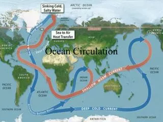
Ocean currents cont. • Three kinds • 2. sub-surface currents - Fig 7.28 p 225 are driven by the sinking of chilled waters from the polar oceans that spread out through all the oceans and eventually return to the surface to be warmed (account for the mixing of the ocean waters) temperature-salinity (thermohaline) differences
Ocean currents cont. • Three kinds • 3. boundary currents - follow parallel to the continental margins • East-west currents in open ocean • North-south currents are results of deflection by land • Mapped from observations averaged over last century • Driven primarily by prevailing winds so they resemble those surface winds - average atmospheric circulation (Remember Fig. 6.11)
Ocean currents cont. • Nearly closed current patterns in ocean basins -subtropical gyres - centered in the subtropical region north and south of the equator and polar gyres best developed in the Atlantic waters between Greenland and Europe and in the Weddell sea off Antarctica • Monsoons in Indian Ocean cause seasonally variable currents Fig 7.18 p 214 (book) (remember monsoons from last time)
A body in motion tends to remain in motion unless acted upon by another force. • Think continents and ocean waters.
CORIOLIS EFFECT • Quick review: • What held for the atmosphere, holds for currents in the oceans. • At the north pole • rocket goes straight up • then comes straight down one hour later • Rockets speed to east or west is what ever the land was doing at the time of launch
CORIOLIS EFFECT cont • Rocket from pole shoot for 30 degrees N (Canary Islands) • Earth rotates ~1400 Km/hr at Canary Islands • The Rocket lands 1400 Km west of Islands one hour later
CORIOLIS EFFECT cont • Rocket starts at the Equator • Equator is moving faster than the Canary Islands at 1600 Km/hr • The rocket lands 200 Km east of Canary Islands
Ekman spiral Fig 7.7 P 201 • Caused by steady wind blowing across water surface, therefore wind driven • Currents diminish in strength and rotate to right with increasing depth because of Coriolis effect • USE (L) INDEX FINGER TO INDICATE WIND DIRECTIONAND CUPPED HAND TO INDICATE EARTH ROTATION
Ekman spiral cont. • Because of Coriolis effect, the surface current moves in a direction 45° to the right of the wind in the Northern Hemisphere and left in Southern Hemisphere
Ekman transport • is perpendicular to wind direction S&A 54 WIND DRIVEN • direction and speed of flow change with depth • surface waters converge in center of basins • waters are transported away from equator and land in certain areas, causing up welling
Take out time to carefully read the section on ocean gyres Table 7.1 p 199 Fig. 7.5 p 198 (wind driven currents)
Geostrophic currents • currents where water flow due to gravity is balanced by deflection of Coriolis effect (difficult concept) Fig 7.8 P 203, S&A 55 • 1. Remember Ekamn transport always turns water currents to the right in Northern Hemisphere, and this clock wise rotation tends to produce a convergence of water in the middle of the gyre.
Geostrophic currents cont. • 2. Water piles up in the center of the gyres - can be > 1 meter above the water level at the margins of the gyres T 85
Geostrophic currents cont. • 3. As Ekman transport continually pushes water into the hill, gravity also acts to counter this effect moving water down the surface of the slope Fig 7.8 p 203. Coriolis effect deflects the water flowing down the slope to the R in Northern Hemisphere
Geostrophic currents cont. • 4. Sargasso Sea is the classic example of gyre in geostrophic balance (home work print off a page showing the 1. location of the Sargasso Sea and 2. its biota for next time) • 5. Ocean surface topography caused by winds (Ekman transport) mapped using data on temperature and salinity remember what a topographic map is. • 6. Ocean current model SA 55
geostrophic flow • refers to cyclonic fluid motions that are maintained as a result of a near balance between a gravity-induced horizontal pressure gradient and the Coriolis effect
BOUNDARY CURRENTS more changeable than the major currents Fig 7.5 p 198 currents Table 7.2 p 204 (remember what currents I want you to know)
Western boundary currents • strongest in oceans - well developed in the Northern Hemisphere Gulf Stream in the Atlantic - Kuroshio in the Pacific • Gulf Stream - 20o C salinity around 36%o • Deep, narrow, swift - can not come up on continental shelf (western intensification) • Intensified by Earth's rotation (clock wise)
Western boundary currents cont. • Often meander and spin off rings that move separately (we will see these later, but keep them in mind) • Separated from adjacent slower-moving waters are oceanic fronts, which are marked by changes in water 1. color, 2. temperature, and 3. salinity
Eastern boundary currents • weaker than western boundary currents • Broad, shallow, slow-moving - can readily flow over continental margins • Often associated with up welling areas • Arctic Ocean currents • Ocean currents follow the same hydraulics as rivers: wide - slow; narrow - fast
Four processes acting together intensify western boundary currents Fig 7.8 a p 203 S&A 55 • 1. earth's rotation which displaces gyres toward the west, compressing them against the continents, thus surface slopes are steeper on the western side of basins (think about steep banks along rivers) • 2. trade winds which blow generally westward along the equator, thus piling up the surface waters on the western sides of basins
3. strong westerlies force surface waters in the mid-latitudes to flow toward the equator as they move across the basin • 4. current and apparent spin due to earth's rotation are in the same direction giving currents a higher velocity - Coriolis effect
WIND INDUCED CIRCULATION • Up welling and down welling, Fig 7.13 p. 207 T 87 S&A 61 Caused by Ekman processes Fig 7.6, 7.7 in the book p 201
Up welling occurs when surface waters move away from the coast exposing subsurface waters The equator is a divergence zone which is caused by the winds and by the changes in the sign of the Coriolis effect Fig 7.10 p 206 (book) • Down welling occurs where waters are moved on shore and causes currents to move parallel to the coast • Fig 7.11 p 206 (book) Water that piles up in gyres sinks slowly to the bottom
GOOGLE/ You tube • Type rings and meanders animations in search line. Then go to the animation, and WALLA!! Many good things and pictures about ocean circulation. I am impressed. • http://www.youtube.com/watch?v=_vAp1c6m8Sk
Rings and meanders • Fig. 7.17 p 213 S&A 58 • Pronounced meanders of western boundary currents • Break off to form isolated rings that move with surrounding waters • Best known associated with Gulf Stream • cold core rings occur in Sargasso Sea warm core rings occur in slope waters • Eddies are equivalent to atmospheric storms - are weaker than rings
Langmuir circulation • Near-surface phenomenon S&A 59 • Caused by strong winds - water rotates at a very low rate • Causes small-scale up welling and down welling forms straight rows parallel to the direction of the wind trapping plants etc. in zones of convergence between the cells (can be 100 m in length) - little plant material at zones of divergence (you can see Langmuir circulation on Lake Michigan)
Thermohaline circulation • (temperature salinity) circulation - currents controlled by density See this on YouTube • http://www.youtube.com/watch?feature=endscreen&NR=1&v=LkRQjTdTvFE • Dense water masses form in high latitudes • Water return to surface throughout the ocean and in up welling regions Fig 7.27 p 224 • Studied by geostrophic calculations and tracer techniques • Oriented generally north-south basins • Current patterns in Atlantic are simpler than in Pacific
Convergence/divergence circulation (Fig 7.5 p 198) A&S57, 60 – Water return to surface throughout the ocean and in up welling regions (divergence) – Water circulates downward (convergence)
Pacific Ocean surface currents • Fig 7.20 p 216 (book) • Box 7.1 p 206 Read this in the book.
Atlantic Ocean surface currents • Fig. 7.16 p 211 (Benjamin Franklin) • Look again at Box 7.2 p 210
Salt lenses • Subsurface equivalent to rings and eddies. Mediterranean Water eddies, or “meddies”, are large, warm, isolated lenses of highly saline Mediterranean Water that are found in the North Atlantic ocean. • Studied by acoustic tomography • Seen in geostrophic circulation Fig 7.8 p 203
Density Structure • Fig 7.27 p 224 S&A 96
Water column • stable - dense below • unstable - dense above (water tips over) • We talked about this in the chapter on water.
Depth changes • pycnoclineFig 5.24 p 153 • density increases rapidly with depth • thermocline Fig 5.25 p 154 • rapid temperature change with depth (this can be several meters thick) • Thermohaline Fig 5.25 p 154 • change in temperature and salinity with depth
Depth changes • Halocline Fig 5.22 p 151ß • large changes in salinity with depth (read to class) • (temperature salinity) circulation - currents controlled by density relationships • Dense water masses form in high latitudes • (convergence) Fig 5.25 p 154 • change in temperature and salinity with depth
Putting it all together • S&A 97
Surface Layer Temperatures • see what wind does S&A 98 • Go to google, type in thermocline changes seasons: click on images • summer - no strong winds • fall and spring - wind mixing and shallow thermocline • winter increasing winds - large mixed layer, no shallow thermocline
Comparing • Atlantic Ocean S&A 100 • salinity/temperature profiles • Pacific Ocean S&A 101 • salinity/temperature profiles
Anatomy of the Atlantic Ocean • S&A 99