Ocean Circulation
Ocean Circulation. At 50°N, you’ll find both polar bears and palm trees…. Polar Bear Provincial Park; Ontario, Canada. Scilly Isles; Britain. 50°N latitude. www.polarhusky.com/logisticsmaps-and-route/circumpolar. Ocean Circulation.


Ocean Circulation
E N D
Presentation Transcript
Ocean Circulation At 50°N, you’ll find both polar bears and palm trees…. Polar Bear Provincial Park; Ontario, Canada Scilly Isles; Britain
50°N latitude www.polarhusky.com/logisticsmaps-and-route/circumpolar
Ocean Circulation • Why the great difference in climate between interior Canada and the British Isles? • Cold air flowing over Canada’s cold interior loses heat, but is warmed when it reaches the Atlantic Ocean and the Gulf Stream • The Gulf Stream is a current, a moving mass of water driven by wind and differences in water density
Ocean Circulation • There are 2 major types of currents: • Surface currents are wind-driven movements of water at or near the ocean’s surface (uppermost 400 meters of ocean); involve ~10% of the world’s ocean water • Thermohaline currents are slow, deep currents that arise from density differences caused by variations in water’s temperature and salinity
Surface currents • Surface currents move water horizontally, and are primarily driven by winds • Waves on the sea surface transfer energy from the moving air to the water by friction; the water flowing beneath the wind forms a surface current • Only 2% of wind speed is transferred to ocean current
Surface currents • When water moves down slope, the Coriolis effect intervenes! • Because of the Coriolis effect, surface currents in the Northern Hemisphere flow to the right of the wind direction, and in the Southern Hemisphere flow to the left of the wind direction • Additionally, continents and submarine topography frequently block or deflect flow into a circular pattern, called a gyre
The formation of gyres Clock-wise Counter clock-wise (Winds driven by uneven solar heating)
Surface currents • The trade winds which blow from the southeast in the Southern Hemisphere, and from the northeast in the Northern Hemisphere set the current in motion between the tropics (equatorial currents) • When equatorial currents reach the western boundary of the ocean basin, they must turn because they cannot cross land; Coriolis deflects these currents away from the equator (western boundary currents)
Western boundary currents Equatorial currents
Western boundary currents • Western boundary currents are fast, narrow, and deep surface currents that carry warm water from the equator to the poles • Eastern boundary currents, on the other hand, flow back across the ocean basin carrying cool water from the poles to the equator
Ekman Spiral and Transport • The collision of air molecules (in wind) with water molecules at the sea surface generates the water current • Once this surface film of water molecules in set in motion, they exert a frictional drag on the water molecules immediately beneath them, getting these to move as well • If the wind blows persistently, motion is transferred downward into the water column
Ekman Spiral and Transport • As this wind-driven current deepens, its speed diminishes (decreases) because of the growing distance from the driving force (the wind) • The current’s flow direction also changes with depth, the result of Coriolis deflection! • When this topmost layer sets the underlying layer of water in motion, this deeper layer also moves to the right of the direction of flow with each successively deeper layer deflected to the right of the layer immediately above it
Ekman Spiral and Transport • Under the influence of a strong, persistent wind, the Ekman spiral may extend downward to a depth of 100-200 meters (~330-660 feet) • The net transport* over this entire wind-driven spiral is 90° to the right of the wind direction in the Northern Hemisphere *net transport represents the average of all directions and speeds of the Ekman spiral
Ekman Transport *The immediate surface water moves in a direction of 45°; the overall transport of the water is 90°
Ekman Transport and Surface Currents • The Ekman transport describes an ideal situation, but ideal conditions rarely exist in nature, so the actual movement of the surface currents deviate slightly from that expected from the Ekman spiral • In shallow waters, for example, the Ekman transport can be very near the same direction as the wind
Ekman Transport and Surface Currents • Because Ekman transport deflects surface water 90° to the right (in the Northern Hemisphere), as gyres rotate clockwise, a convergence of water occurs in the middle of the gyre • Causes water to literally pile up in the center of the gyre • Creates a hill of water that is up to 2 meters (6.6 feet) in height
Western boundary currents are very fast and deep because there is a westward intensification of water piling up due to the eastward rotation of the Earth & Coriolis
North America Europe Equator
The Gulf Stream • Remember, the Gulf Stream is a western boundary current • Transports warm, tropical water northward • Together with its eastward extension, the North Atlantic Current or Drift, keeps Ireland and the west coast of Great Britain warm, and parts of Norway ice- and snow-free year round
The Gulf Stream sometimes meanders, forming rings or eddies that trap cold or warm water in their centers • Warm-water eddies bring coconuts and tropical fish to Long Island!
Wind can cause vertical movement of water • Wind-driven water is usually horizontal in nature, but can sometimes induce vertical movement in the surface water • Upwelling is the vertical movement of cold, deep, nutrient-rich water to the surface • Enhances productivity, which can support incredible numbers of large marine life • Downwellingis the vertical movement of surface water to deeper parts of the ocean • Decreases productivity, but transports necessary dissolved oxygen to organisms on the deep-sea floor
Upwelling • When surface waters move away (or diverge) from an area on the ocean’s surface, upwelling occurs • Upwelling commonly occurs along the equator (equatorial upwelling) and along the west Coast of the United States (coastal upwelling) • Creates areas of high productivity that are some of the most prolific fishing grounds in the world
El Niño • Under ‘normal’ circumstances, upwelling brings cold, nutrient waters to the coasts of Peru, driving an important anchovy fishery Pacific Warm Pool
Normal conditions Pacific Warm Pool The Pacific Warm Pool contains some of the warmest water on Earth; very low in nutrients
El Niño • Every few years, a current of warm water occurs off the coast of Peru, reducing the commercial catch of anchovies • Sea birds and seals that depend upon the anchovies for food suffered as well • The warm current brought with it increased rainfall (good for Peru; usually arid) • Usually occurred around Christmas and was named “El Niño”; today known as the El Niño – Southern Oscillation (ENSO)
El Niño • During an El Niño, the high pressure zone along the coast of South America weakens, reducing the pressure gradient difference (high to low) • Causes southeast trade winds to diminish (or in extreme cases, to blow in the opposite direction!) • Without the trade winds, the warm water pool on the western side of the Pacific begins to flow towards South America
El Niño • The Pacific Warm Pool creates a band of warm water that stretches across the equatorial Pacific Ocean • Begins moving in Sept and reaches the coast of Peru ~Dec or Jan; temperature of seawater off Peru can increase <10°C (18°F) during this time! • Sea level can increase as much as 8 inches, simply due to thermal expansion of water along the coast!
La Niña • Occasionally, conditions opposite of El Niño occur; these are known as ENSO cool phase, or La Niña • La Niña is characterized by normal conditions intensified, resulting in stronger trade winds, causing more upwelling, and a band of cooler water stretching across the equatorial Pacific • Usually occurs after an El Niño event; enhanced productivity (good)
El Niño and La Niña • El Niño conditions occur on average every 2 to 10 years, but on a highly irregular basis • Increased global warming may be promoting, and/or enhancing El Niño events; increased sea surface temperatures can trigger more frequent and more severe events • Strong El Niño events can alter global weather patterns, resulting in flooding, droughts, fires, tropical storms, and erosion
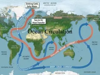
Deep Ocean (Thermohaline) Circulation • Subsurface, or deep ocean currents, arise from density differences between water masses produced by variations in temperature (thermal effect) and salinity (haline effect) • For this reason, they are collectively referred to as thermohaline circulation
Deep Ocean (Thermohaline) Circulation • Deep water currents move large volumes of water and are much slower than surface currents • It takes a deep water current an entire year to travel the same distance as a western intensified surface current can move in one hour! • Although temperature and salinity both affect the density of seawater, temperature has a greater influence on density
Deep Ocean (Thermohaline) Circulation • Most water involved in deep-ocean currents originated at the surface in high latitudes • There, the surface water cooled and its salinity increased as sea ice formed (both increasing its density) • When this surface water becomes dense enough, it sinks, initiating deep ocean currents