Ocean Circulation
Ocean Circulation. Chapter 9. Geostrophic Currents. As water moves it is constantly deflected by the Coriolis Effect This effect pushes water into a hill in the center of the gyre. It is about 1 meter high in the center of the Atlantic Nevertheless, it IS a hill, and water runs downhill.


Ocean Circulation
E N D
Presentation Transcript
Ocean Circulation Chapter 9
Geostrophic Currents • As water moves it is constantly deflected by the Coriolis Effect • This effect pushes water into a hill in the center of the gyre. • It is about 1 meter high in the center of the Atlantic • Nevertheless, it IS a hill, and water runs downhill. • This is shown by the arrow labeled 'gravity' in the diagram.
There is a balance between the pushing in of the Coriolis effect, and the flowing out by gravity (which deflects to the right in the N. Hem.), which keeps the whole thing spinning as a geostrophic current. • So, once the winds get the gyres moving, they are somewhat self-perpetuating.
Gulf Stream • Best-studied of the ocean currents • The Gulf Stream, like streams on land, wobbles. • These wobbles are known as eddies. • It wobbles outward, as shown in diagram a, and wobbles inward, as shown in diagram b.
The wobbles often wobble so far, that a whole gob of Gulf Stream water pinches off from the stream and heads south (diagram a) or north (diagram b). • These are known as rings. This is yet another way by which warmth is sent from the Gulf Stream to the northeast coast of North America. • Notice the rings spin.
The outward wobble (a) takes cold water (shown in blue) from off the coast of New England (or northeast Canada) and sends it to the center of the North Atlantic gyre (an area known as the Sargasso Sea). • The inward wobble (b) takes warm water (shown in red) and sends it up to the coast of New England.
The Ekman Spiral • When wind blows over the surface of the water, we expect it to drag the water along with it, in the same direction. • However, it doesn't. • You may have noticed that the Trade Winds, which move the Equatorial Currents, are blowing diagonally across the map, but the water is moving horizontally. • What's going on? The Coriolis Effect, again!
The Trade Winds blow from the northeast in the northern hemisphere. • The water they drag along is deflected to the right. • Now this water is moving is a given direction, and it drags the water just beneath it with it. • The water just beneath the surface is also deflected to the right. • THIS water drags water beneath IT, which is also deflected to the right.
This effect continues with deeper and deeper water for 100-200 m. until friction stops the motion. • But at the bottom of this dragging and deflecting, water can be moving in the opposite direction of wind flow!!! • The average direction of flow for the current is about 45° to the right of the direction of the wind.
Surface Winds • The surface winds are the ones which blow over the surface of the ocean and cause ocean currents. • The Trade Winds push North Atlantic water westward, forming the North Equatorial Current. • This current runs into the West Indies (Caribbean Islands) and then turns northward.
Warm waters from the Caribbean and the Gulf of Mexico join this water and these currents form the Gulf Stream, which moves along the west side of the Atlantic. • Notice that the Gulf Stream becomes deflected to the right! • In addition to the Coriolis Effect, the Gulf Stream begins to flow under the influence of the Westerlies, which push this current across the North Atlantic.
The North Atlantic current runs into northwest Europe (the British Isles), and deflects to the right. • Now the water flows southward as the Canary Current to complete the North Atlantic Gyre. • Part of the North Atlantic splits off and flows northward forming the Norway current.
Part of the water flows between Greenland and Canada, into the Arctic Ocean • It comes back southward as the Labrador Current, bringing icebergs that calved off western Greenland with it.
Another part flows between Iceland and Scandinavia, into the Arctic Ocean, and comes back out into the Atlantic between Greenland and Iceland as the East Greenland Current, again, bringing icebergs from east Greenland with it. • These branches off the North Atlantic Gyre are what sunk...various ships in the North Atlantic.
There is a similar gyre in the South Atlantic, but it flows counterclockwise, because the Coriolis Effect deflects motion to the left in the southern hemisphere. • The Trade Winds blow the water westward across the South Atlantic as the South Equatorial Current. • This water runs into South America and is deflected to the left, or south, to form the Brazil Current.
The Brazil Current is the S. Atlantic's equivalent to the Gulf Stream. • As it flows southward, the Brazil Current is deflected to the left to form South Atlantic current moving eastward towards Africa. • Where it runs into Africa, it is deflected left, or northward, and moves along the African coast as the Benguela Current, to complete the gyre.
Currents of the Pacific Ocean • The Pacific Ocean also has a gyre in the northern and the southern part: • In the Northern Hemisphere: • The Trade Winds push the water westward across toward the Philippines as the North Equatorial Current. • This is deflected to the right and becomes the Kuroshio Current, which is the North Pacific's equivalent to the Gulf Stream.
It flows past Japan. The Westerlies push on this current, and the Coriolis Effect deflects it to the right across as the North Pacific Current. • It runs into North America and is deflected right to become the California Current and complete the North Pacific Gyre. • As in the Atlantic, there are a couple of branches northward, forming the Alaska Current and the Kamchatka Current.
Notice the water along the west coast of the U.S. (the California Current) is coming down from the north, where it's been chilling out for weeks. • This is why the Pacific coast is cold for swimming. • In the Southern Hemisphere, you can follow the arrows: South Equatorial Current to E. Australian Current, across as the South Pacific Current and then to the Peru Current.
The Pacific and Atlantic Oceans have an Equatorial Counter Current to keep water from piling up on the west side of the ocean. • Warm equatorial water bathes the northeast coast of Australia, but cold polar water bathes the west coast of Australia. • This is why there is so much more reef growth (the Great Barrier Reef) on the east side of Australia than on its west.
The Currents of the Southern Ocean • The Southern Ocean is the water around Antarctica, the continent at the South Pole. • The Southern Ocean is actually the southern ends of the Atlantic, Indian, and Pacific Oceans. • Because it has a unique current system, most oceanographers recognize it as a separate ocean.
It has little connection with the gyres of any other ocean, although it does downwell and circulate in the subsurface back to the equator • There's a lot of other things going but the one to notice is the West Wind Drift.
El Niño - Southern Oscillation (ENSO) • Periodic elevation of sea surface temperature in the Equatorial Pacific Ocean • A strengthening of the equatorial counter-current develops as a result of a pressure change that reduces the SE Trade Winds. • With the Trade Winds weakened, water that is normally pushed into the western Pacific by the wind flows eastward.
The warmer water over-rides the typical cold water of the eastern Pacific and deepens the thermocline. • A very deep layer of warm water accumulates in the typically cool eastern Pacific.
ENSO Effects • Has a major affect on weather, especially in regions bordering the Pacific: • Hurricanes in the South Pacific • Heavy rain in eastern Pacific, especially western South America • Droughts in western Pacific and Australia • Droughts in eastern Africa have also been correlated with El Niño
La niña • Normal condition stronger than normal • Colder than normal temperatures • Strong currents with strong upwelling
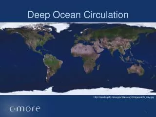
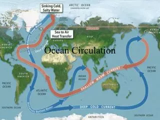
Deep Ocean Currents • Density differences, together with winds, are the principal factors determining ocean currents. • Winds are the primary driving force of the surface circulation, which is also called wind-driven circulation • Density differences drive the deep, or vertical, circulation of the oceans.
The density of seawater is controlled by temperature and salinity, so the deep circulation is also called the thermohaline circulation. • Temperature differences as small as a few hundredths of a degree and salinity differences of a few parts in a hundred thousand can be important. • Both temperature and salinity are conservative properties of seawater, that is, there are determined by processes occurring at the surface.
Formation of Deep Water Masses • Deep waters are generally formed in high latitudes (because of cooling and thermal contraction). • They then sink to level of neutral buoyancy, spread out and slowly return to surface over 100's of years.
Mediterranean Intermediate Water (MIW) • Saline >38‰, relatively warm water formed in Mediterranean, • flowing out through Gibraltar and sinking to ~ 1000 m in Atlantic.
North Atlantic Deep Water (NADW) • Formed by winter cooling of upwelling saline water around Iceland. • Piles up to ridge depth and flows out southward, rising again at Antarctic Divergence.
Antarctic Intermediate Water (AAIW) • Forms at the Antarctic Polar Front and currents pile up water produces a convergence. • This is not as cold or saline as NADW, so it stays above it, moving northward.
Antarctic Bottom Water (AABW) • Densest, and most widespread deepwater mass: found in Atlantic, Pacific and Indian. • Formed by cooling in Polynyas (areas free of ice) around Antarctica. • Freezing of ice increases salinity and density of this water.
Equatorial Circulation • Inter-tropical Convergence Zone (ITC): climatic equator. • North and South Equatorial currents run east to west, driven by trade winds. • Equatorial Counter Current runs west to east within ITC.
Equatorial Undercurrent occurs at a depth of about 50 to 100 m on equator runs east to west. • There is a divergence, and hence upwelling at the equator.