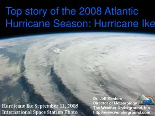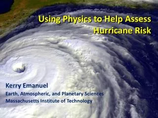
IMPROVING HURRICANE PREPAREDNESS & RESPONSE
IMPROVING HURRICANE PREPAREDNESS & RESPONSE. MAX MAYFIELD NATIONAL HURRICANE CENTER. WHERE AMERICA’S CLIMATE AND WEATHER SERVICES BEGIN. Employing new communication technology Enhancing public outreach & education. TPC Watch/Warning/Wind Graphic. Advance Notice – Specific to Area.

IMPROVING HURRICANE PREPAREDNESS & RESPONSE
E N D
Presentation Transcript
IMPROVING HURRICANE PREPAREDNESS & RESPONSE MAX MAYFIELD NATIONAL HURRICANE CENTER WHERE AMERICA’S CLIMATE AND WEATHER SERVICES BEGIN
Employing new communication technology • Enhancing public outreach & education
Presenting Information Effectively?Distribution of Wind around a Hurricane HURRICANE MICHAEL FORECAST/ADVISORY NUMBER 7 NATIONAL WEATHER SERVICE MIAMI FL AL1700 1500Z WED OCT 18 2000 64 KT....... 20NE 20SE 20SW 20NW. 50 KT....... 60NE 60SE 30SW 30NW. 34 KT.......120NE 120SE 90SW 90NW. 12 FT SEAS..150NE 240SE 240W 150NW.
HRD WIND ANALYSIS IRENE 0130 UTC 17 OCT 1999 Actual Hurricane Force Winds due North of Center Are interpreted as
OUTREACH & EDUCATION WORLD METEOROLOGICAL ORGANIZATION INTERGOVERNMENTAL NATIONAL PARTNERSHIPS THE PUBLIC THE MEDIA
Coordinates TC warnings and watches RSMC Miami
HLT Communication Flowchart FEMA EST National Hurricane Center @ the Tropical Prediction Center FEMA ROCs HLT State EOCs HLT Hurricane Hotline Local NWSFOs Local EOCs
Hugh Cobb (NWS) and Bill Massey (FEMA) at the Hurricane Center give the HLT Video Briefing FEMA Director Witt with other Federal Agency participants at FEMA HQ receive the HLT Video Briefing
Satellite Loops RadarImages Sample Broadcast Graphics HURREVAC Graphics Storm Surge Loops