Download
1 / 1
10 likes | 197 Vues
Multi-Sensor Image Fusion (MSIF) Team Members: Phu Kieu , Keenan Knaur Faculty Advisor: Dr. Eun -Young (Elaine) Kang Northrop Grumman Liaison: Richard Gilmore Department of Computer Science College of Engineering, Computer Science, and Technology California State University, Los Angeles.

E N D
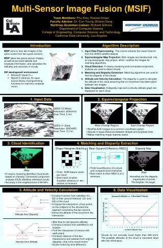
Multi-Sensor Image Fusion (MSIF)Team Members: Phu Kieu, Keenan KnaurFaculty Advisor: Dr. Eun-Young (Elaine) KangNorthrop Grumman Liaison: Richard GilmoreDepartment of Computer ScienceCollege of Engineering, Computer Science, and TechnologyCalifornia State University, Los Angeles Introduction Algorithm Description • MSIF aims to fuse two images of the same scene from two space sensors. • MSIF takes two space sensor images, as well as per pixel latitude and longitude information, and calculates the altitudes and velocities of clouds. • SW development environment • Microsoft Visual C++ • OpenCV Libraries: An open source library of programming functions for real time computer vision. Input Data Preprocessing : The routine extracts the visual channel from the GOES satellite dataset Equirectangular Map Projection: Both images are transformed into an equirectangular map project, which rectifies the images for matching algorithms. Cloud Detection: K-means clustering and connected component analysis are used to detect clouds. Matching and Disparity Extraction: Matching algorithms are used to find the disparity of the clouds. Altitude and Velocity Calculation: The disparity is used to calculate the altitude of the cloud assuming that no movement has taken place between two images. Data Visualization: A disparity map and a velocity-altitude graph are displayed for each cloud. 1. Input Data 2. Equirectangular Projection GOES-12 (West) Resolution: 2500x912 Scan Time: 5 min. GOES-11 (East) Resolution: 2000x850 Scan Time: 15 min. West (Overlap Region) East (Overlap Region) • Rectifies both images to a common coordinate system • Results in equal distances between latitude and longitude lines • Makes matching image features easier 3. Cloud Identification 4. Matching and Disparity Extraction Shape Histogram Matching Mean Squared Difference (MSD) Disparity Map ? ? • Finds bounding box of a cloud, and compares pixel intensities • Best match is when MSD is at a minimum West • Finds SHM feature vector per cloud • Best match is when Euclidian distance of two vectors is minimum West • K-means clustering identifies cloud pixels based on intensity. Connected component analysis (CCA) identifies individual clouds • Accuracy in the neighborhood of 85-90% Intensities are the disparity magnitudes of clouds. The brighter, the larger. 5. Altitude and Velocity Calculation 6. Data Visualization • Construct vectors from satellites (S1, S2) to their ground intersect (G1 and G2) of the cloud • Compute the intersection of two points (or the midpoint of the shortest line segment connecting the two vectors) • Derive the altitude of the cloud from the intersection Altitude from Disparity • Alter blue to red (assume altitude) • Construct vectors from satellites to red location • Find the intersection of vectors with earth plane • Compute distance of the two intersections and subtract from original disparity—this is the cloud motion • Divide motion by time difference Clouds do not normally travel faster than 200 km/h. The possible altitudes of the cloud is narrowed down with this information. Velocity from Altitude