Download
1 / 1
10 likes | 115 Vues
1/2 road’s wide from center line on roads+5m. Residential. Park. Agriculture areas. The Fourth IPSI Conference. A survey of vegetation types adjacent to walking routes around Satoyama areas border suburban residential area. Introduction.

E N D
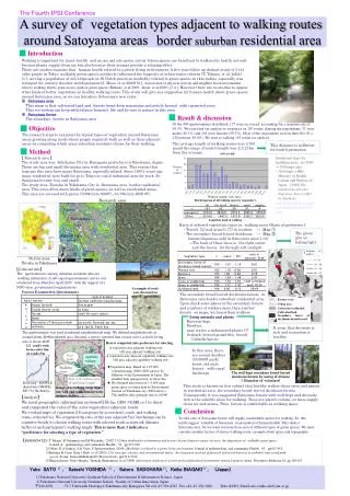
1/2road’s wide from center line on roads+5m Residential Park Agriculture areas The Fourth IPSI Conference A survey ofvegetation types adjacent to walking routes around Satoyama areasborder suburban residential area Introduction Walking is importantfor man’s healthand an easy and safe aerobic activity. Green spaces are beneficial to walkers for health not only because plants supply clean air, but also because their aromas provide a relaxing effect. There are studies examine thathuman health related to a green living environment. A five year follow up chohort study of 3144 older people in Tokyo, walkable green spaces positively influenced the longevity of urban senior citizens (T. Takano. et al. 2002,) [1.], serving a population of 345,143people in 96 Dutch practices morbidity related to green spaces in 1km radius, especially was strongest for anxiety disorder and depression.(J. Mass. et al.2009) [2.], Association of physical activity and neighbor hood environment what to walking streets, park access, park or green spaces (Bethany. et al.2009, Inoue. et al.2009,) [3.4.]. However there are no studies to appear what kinds of better vegetation on healthy walking routs. This study will give any suggestion for human health about green spaces around Satoyama area, so we can introduce Satoyama’s new value. ※Satoyama area This mean is that cultivated land and forests (semi-deep mountains and article forests) with connected river. This eco-system can keep with balancehuman’s life and by care to nature in this area. ※Satoyama forest The secondary forests in Satoyama area. Result & discussion Of the 400 questionnaires distributed, 177 were recovered, accounting for a response rate of 44.3%. We restricted our analysis to responses on 167 routes. Among the respondents, 71 were males (40.1%) and 105 were females (59.3%). Most of the respondents were in their 60s (N = 130 persons, 83.0%). We used to walking 167 routes for analysis. Objective The research aims to examine the typical types of vegetation around Satoyama areas growing along roads where people regularly walk as well as their adjacent areas by computing which areas suburban residents choose for their walking. The average length of walking routes was 3,763 mand the range of route’s length was ±2,214m from the average. This distance is sufficient for health promotion. Method 【 Research area 】 The study area was Yokohama City in Kanagawa prefecture in Yokohama, Japan. There are big and small Satoyama area with residential area. This reason that long ago this area have many Satoyama, especially inland. Since 1950’s years ago, many residential were built for go to Tokyo or costal industrial area for work. So Satoyama became less and small. The study area, Tostuka in Yokohama City is Satoyama area border residential area. This area offers many kinds of green spaces, as well as residential areas. This area are covered with green 70.8%(into 500㎡)、63.7%(into 2000 ㎡). Intentional steps for health promote are 4000~7000steps /day. ( 5000steps =4㎞) Ministry of Health, Labour and Welfare of Japan (2008)The national health and Nutrition Survey2005 in Japanese http://www.mhlw.go.jp/bunya/kenkou/eiyou07/01.html. Number of walker Walking length / routs (km) Research area The histogram of all walking routs by responder’s Length by kind of walking Ratio of selected vegetation types on walking route (Ratio of preference). ・ Trees(1.72) and grass(1.77) in resident → Map ① ・ The secondary broad-leaved deciduous → Map ② forests (Japanese oak) in Satoyama area(1.33) →The bark of these trees isthe rightcolour and the leaveslet through soft sunlight The green give us feeling light. Number of walker Survey area Totuka in Yokohama Google ② 【Collected data】 Thequestionnaires among suburban residents who are walking enthusiasts. A self-report questionnaire survey was conducted from March to April 2009with the support of a NGO (non- governmental organization). ① Forest • A example of routs • were drowned on • map of questioner Factors Examined in Questionnaire The questionnaire was used residential neighborhoods map. We defined neighborhoods as around about 4k㎡residential area. Because a survey reported that citizen active at daily living area is about 4k㎡. The secondary broad-leaved deciduous forestsin Satoyama area border suburban residential area. Upon check some places of the secondary forests and numbers of walkers more than another forestson maps, we hared from walkers Factory area Urban area Green into residential Cultivated land Secondary forest of deciduous broad-leaved living animals and plants Raccoon-dogs, Fireflies, near water, a endangered-plants (?) Goshawk (forward ground thisforest) :Umbrella Species It seem that diversity is rich and ecosystem is healthy. How to computed ratio preference for selecting A vegetation area adjacent walking rout /All area adjacent walking rout A vegetation area adjacent capability walking rout /All area adjacent capability walking rout In this area, there are second deciders (35.000㎡ park) forest, old style factory , with rural landscape Start point capability walking Walking route ★Vegetation map: Based on 1:25.000 vegetation map (2000, 2001 survey) by Ministry of the Environment in Japan. The smallest data (paragon size) is about 1ha. ★ We obtained data based on 1:3.000 open green space coverage map by Environment Section of Yokohama-city (2004.survey). The smallest data (paragon size) is 100㎡ • The well-kept secondary broad-leaved deciduous forests by caring of citizens • ( 50menber of volunteer) Forest Into1/2 radius area of walking length Road map : MAPPLE digital data (SHAPE) Rel.5 by Shobunsya This study is known on this subject that healthy walker chose trees and grases in residential area, the secondary broad-leaved deciduous forests.Consequently it was suggested Satoyama forests with well-kept and diversity rich is the suitable place for walking. Trees are plant’s volume, so more supply clean air and aroma. Thus forests is comfortable as walking space. Image of a walking route figure into GIS and roads into network distance buffers. 【Analyze】 We used geographic information systems(GIS:Arc GIS9.3-ESRI co.) to draw and computed the ratio of the area vegetation adjacent roads. We overlaid maps of vegetation (18 categories by ecosystem), roads, and walking routes collected via. We computed the ratio of the area adjacent 5m(3m=human can be cognitive beside) to chosen walking routes with selected roads as network distance buffer of each participant’s walking length. This is more than 1 indicates a “preference for selecting a type of vegetation.” Conclusion To take care of Satoyama forests will supply comfortable spaces for walking. So this result suggest valuable of Satoyama in promotion of human health. This study a Satoyama area. So we want to research on area of different types of green spaces. We must consider another factors of choice walking route, example about space and topography. 【REFERENCE】1) T Takano, K Nakamura and M Watanabe. (2002.7.)Urban residential environments and senior citizens longevity mega city area: the importance of walkable green space. Journal of epidemiology and community Health,56,pp.913-918. 2)J Mass, R A Verheij, S de Vries, P Spreeuwenberg (2009.) Morbidity is related to a green living environment. Journal of epidemiology and community Health,63,pp913-918. 3)Bethany B. Cutts. Kate J.Darb. et al (2009.) City structure, obesity, and environmental justice :An integrated analysis of physical and social barriers to walkable streets and park access. Social Sience&Medicine69 (Elsevier Ltd.), pp1314-1322. 4)Shigeru Inoue, Norio Murase, Teruichi Shimomitsu, et al (2009) Association of physical activity and neighborhood environment among Japanese adults. Preventive Medicine,10, pp.163-167. Yuko SATO 1), Satoshi YOSHIDA2), Satoru SADOHARA 2),Keiko INAGAKI 2) , (Japan) 1)Yokohama National University Graduate School of Environment & Information Science,Japan 2)Yokohama National University Graduate School,Faculty of Urban Innovation,Japan 〒240-8501 79-7 Tokiwadai HodogayaYokohama-city Kanagawa Tel +81-45-339-4247 Fax +81-45-338-1016 Yuko SATO: Email sato-yuuko-sk@ynu.ac.jp