Download
1 / 15
150 likes | 390 Vues
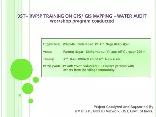
DST- RVPSP TRAINING ON GPS/ GIS MAPPING - WATER AUDIT Workshop program conducted. Organizers: WASSAN, Hyderabad. PI : Dr. Nagesh Kolakani Venue: Farooq Nagar- Mohamedpur Village, off Gurgaon 20km. Timing: 2 nd Nov. 2008, 9 am to 6 th Nov. 6 pm

E N D
DST- RVPSP TRAINING ON GPS/ GIS MAPPING - WATER AUDIT Workshop program conducted Organizers: WASSAN, Hyderabad. PI : Dr. NageshKolakani Venue: Farooq Nagar- Mohamedpur Village, off Gurgaon 20km. Timing: 2nd Nov. 2008, 9 am to 6th Nov. 6 pm Participants: PI with Youth volunteers, Resource persons with others from the village community. Project Catalyzed and Supported By R V P S P , NCSTC Network, DST, Govt. of India.
Objectives • To understand GPS System • To get trained on GPS System • To understand use of GPS System in Village • To perform exercise based upon training
Understanding GPS System • GPS – Global Positioning System. • Developed by the United States Department of Defense. • Used to determine current location. • A GPS receiver calculates its position by carefully timing the signals sent by the GPS satellites high above the Earth.
Use of GPS • Map Location of Water Resources • Create Map of Village with Water Resources • Use the created Map for Planning. • Map help to resolve water fullfillment
Exercise Performed • Identify the sample water resources in village • Map their location using GPS System. • Use the Map to plan.
Exercise Performed….Contd. • Map Created:- • Identified the compound where water is needed • Identified Water Resources around the Compound (marked in Red) • Next Stage: To plan water from identified resources in compound
Using GPS instrument to map the area and available water bodies
Exercise Performed….Contd. Map Created using GPS Receiver. Pts 16 – 19 – Location of compound Pts 20 – 23 – Location of water resource.
Exercise Performed….Contd. Data Collected Using GPS Receiver