Download

1 / 6
2.79k likes | 8.36k Vues
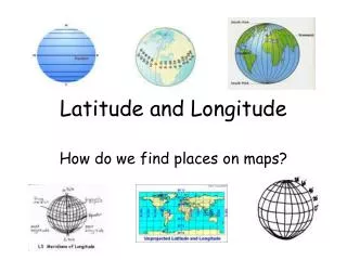
LATITUDE AND LONGITUDE. Basic Concepts. LATITUDE. LATITUDE is defined as a measurement of distance in degrees north or south of the Equator . There are 90 degrees of latitude from the Equator to each of the poles (north or south pole).

E N D
LATITUDE AND LONGITUDE Basic Concepts
LATITUDE • LATITUDEis defined as a measurement of distance in degrees north or south of the Equator. • There are 90 degrees of latitude from the Equatorto each of the poles (north or south pole). • Latitude lines are parallel, that is, they are the same distance apart. That’s why they are called "PARALLELS". • The equator is at 0°. It divides the Earth in half and it's the largest parallel on Earth. • Positions on latitude lines above the Equator are called "north" and are in the northern hemisphere. They are abbreviated with the letter "N.” • Positions on latitude lines below the Equatorare called "south," which is abbreviated with an "S." They indicate the position a point is in the southern hemisphere.
LONGITUDE • LONGITUDEis defined as a measurement of distance in degrees east or west of the Prime Meridian. • The Prime Meridian divides the Earth in half and it’s 0° . • It passes through the community of Greenwich (near London, England). • The Prime Meridian (as do all other lines of longitude), passes through the north and south pole. These lines are NOTparallel. They make the Earth look like a peeled orange. • Longitude lines to the left of the Prime Meridian give locations west, in the western hemisphere. • Longitude lines to the right of the Prime Meridian give locations east, in the eastern hemisphere. • Because the Earth is round like a ball, not all longitude lines are visible. There are 180 other lines of longitude on the other side of the globe. But on the oppositeside of the Prime Meridian, the meridian line is 180° and is called the International Dateline.
EARTH’S GRID • In order to find the exact position of a point over the Earth's surface we use both parallels and meridians togetheras a system of reference, which is called geographic coordinates or geographic grid (or just "Earth's grid"). • Such "coordinates" are measured in (angular) degrees.