Download

1 / 23
350 likes | 1.02k Vues
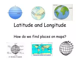
Latitude and Longitude. Latitude. Latitude lines are imaginary horizontal lines on a world or large area map. Latitude lines separate the world into Northern and Southern hemispheres and range between 0 degrees at the Equator and 90 degrees at the North and South Poles. Longitude.

E N D
Latitude • Latitude lines are imaginary horizontal lines on a world or large area map. Latitude lines separate the world into Northern and Southern hemispheres and range between 0 degrees at the Equator and 90 degrees at the North and South Poles.
Longitude • Longitude lines are imaginary vertical lines on a world or large area map. Longitude lines separate the world into the Eastern and Western hemispheres and range between 0 degrees at the Greenwich Meridian (also known as the Prime Meridian) and 180 degrees east and west of Greenwich at the International Date Line.
Each degree of latitude and longitude is subdivided into 60 equal parts called minutes and each minute is divided into 60 equal parts called seconds. On the surface of earth, one degree of either latitude or longitude is about 110 km (69 miles) although it is slightly more at the poles as the earth is not a perfect sphere.
Latitude and Longitude • The earth is divided into lots of imaginary lines called latitude and longitude.
Lines • Longitude lines run north and south. • Latitude lines run east and west. • The lines measure distances in degrees. Latitude Longitude
Where is 0 degree? • The equator is 0 degree latitude. • It is an imaginary belt that runs halfway point between the North Pole and the South Pole. Equator
P R I M E M E R I D I A N Where is 0 degree? • The prime meridian is 0 degrees longitude. This imaginary line runs through the United Kingdom, France, Spain, western Africa, and Antarctica.
Hemispheres • By using the equator and prime meridian, we can divide the world into four hemispheres, north, south, east, and west.
Latitude lines run across the map measured in degrees north and south of the Equator they are parallel decrease in length towards the Poles Longitude lines run up and down the map measured in degrees east and west of the Greenwich Meridian they converge at the Poles they are all the same length Latitude and Longitude….
West 0º East 180º North 66½º Arctic Circle Tropic of Cancer 23½º Equator 0º 23½º Tropic of Capricorn International Date Line Greenwich Meridian Antarctic Circle 66½º South
What are the red lines on this map called? Latitude Longitude
What are the red lines on this map called? Latitude Longitude
Latitude and longitude Match the places with the correct latitude and longitude. 20ºS 140ºE 2 4 1 28ºS 20ºE 5 5 30ºN 90ºE 2 1 3 4 40ºN 120ºW 30ºS 80ºW 3
Latitude and longitude b c e f a d g Write down the latitude and longitude of these places.
Latitude and Longitude Resources • A Printable Latitude & Longitude Map of the World • Latitude and Longitude Quiz • http://olc.spsd.sk.ca/DE/k9mod/Mapskill/mod3fl5.swf Try this interactive • http://www.kidsgeo.com/geography-games/latitude-longitude-map-game.php Try this game
Which has the higher IQ, latitude or longitude? • Longitude, it has 360 degrees!