Download
1 / 13
130 likes | 296 Vues
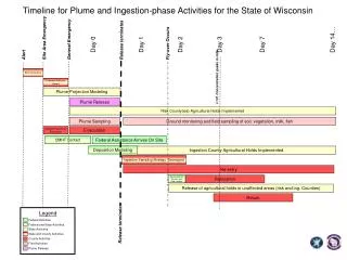
Legend. Federal Activities. Federal and State Activities. State Activities. State and County Activities. County Activities. Field Activities. Plume Release. Timeline for Plume and Ingestion-phase Activities for the State of Wisconsin. Day 14…. Site Area Emergency. General Emergency.

E N D
Legend Federal Activities Federal and State Activities State Activities State and County Activities County Activities Field Activities Plume Release Timeline for Plume and Ingestion-phase Activities for the State of Wisconsin Day 14… Site Area Emergency General Emergency Release terminates Day 0 Day 1 Day 2 Day 3 Day 7 Fly-over Occurs Alert EOC Activation I-131 Concentration peaks in milk Livestock Advisory Issued Plume Projection Modeling Plume Release Risk County(ies) Agricultural Holds Implemented Ground monitoring and field sampling of soil, vegetation, milk, fish Plume Sampling Special Populations Evacuation Evacuation CMHT Contact Federal Assistance Arrives On Site Deposition Modeling Ingestion County Agricultural Holds Implemented Ingestion Sampling Strategy Developed Re-entry Assessment of Fly-over and Field samples Relocation Release of agricultural holds in unaffected areas (risk and ing. Counties) Return Release terminates
Original NPP Utility Spreadsheet Concept of Use Eight general ranges and data within any range is equally applied within the range.
Geographic Information Systems Methods of Generating Geographic Data for Ingestion Pathway Exercises
Spreadsheet with I-131 centerline data for developing off centerline isopleth values needed to plot deposition map.
Section that calculates centerline Latitude/Longitude values.
Final product using FRMAC coloring scheme (with hand-rendered “hot spot”)