Geomorphic Processes in Permafrost Environments: A Detailed Overview
380 likes | 430 Vues
Learn about the diverse geomorphic processes influenced by permafrost, including storm surges, flooding, channel migration, and more across various ecosystems like coasts, floodplains, uplands, and mountains.

Geomorphic Processes in Permafrost Environments: A Detailed Overview
E N D
Presentation Transcript
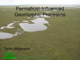
environmental research & services Permafrost-Influenced Geomorphic Processes Torre Jorgenson
Overview of Geomorphic Processes • Coasts • Storm surges, sedimentation, salinization, permafrost degradation • Floodplains • Changing flooding, sedimentation, • Channel migration • Coastal Plain-Lowlands • Thermokarst lakes, waterbody creation • Lake expansion and shrinkage • Paludification, organic matter accumulation • Ice-wedge Degradation • Uplands • Loss of permafrost aquatard, drainage • Thaw slumps • Thermokarst Lakes in Extremely ice-rich loess (yedoma) • Mountains • Slope Failure
Coastal Ecosystems • Sedimentation (up to 10 cm in big year) • Storm Surges (1970 to 2 m) • Salinization (up to 15 km inland) • Sea Level Rise (3 mm/yr)
Storm Surges October 2002 Storm at Barrow
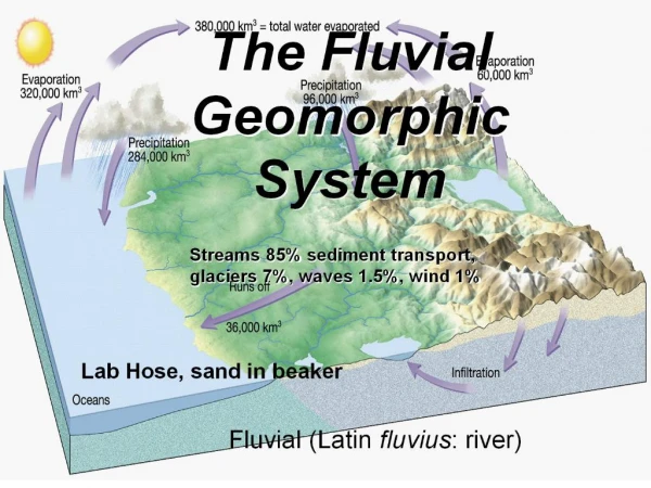
FLUVIAL PROCESSES • Changing flooding, sedimentation, • Channel migration
Upland Sandy Low Scrub Upland Barrens Riverine Barrens Riverine Marsh Riverine Low and Tall Scrub Riverine Wet Meadow Lowland Wet Meadow Riverine Wet Meadows Riverine Lake - Connected Lowland Deep Lake Ecotypes 25-200 yr 1000-2000 years for development 5-25 yr Masssive organics 3-4 yr Layered Organics 1-2 yr Layered fines Rippled sands/fines, with detrital organics Low Water Layered fines w/ clay Massive or Crossbedded Sand GEOMORPHIC PROCESSES ON RIVER FLOODPLAINS Changes over Time: Increasing height, Decreasing flooding frequency, Decreasing sedimentation, Increasing organics, Decreasing thaw depths, Decreasing water depths Decreasing pH Increasing ground ice, Increasing susceptibility to thermokarst,
Decreasing Flooding and Sedimentation River Active-floodplain Cover Deposit Inactive-floodplain Cover Deposit Riverbed/ Riverbars Abandoned- floodplain
Nechelik SCALE IN MILES N 0 1 2 Areas of Erosion and Deposition Area (%) 1.3 Eroded Riverbed/Sandbar 2.6 Riverbed/Sandbar Deposition Channel 7.6 Unchanged Riverbed/Sandbar Channel 1.8 Thaw Basin Drainage/Deposition East 1.0 Other Eroded Terrain River Unchanged Terrain 58.8 Lake-level Change 0.9 Colville Unchanged Water 26.1 Proposed Project In-field Facilities Pipelines Landscape Change from 1955 to 1992, Central Colville River Delta Nuiqsut Erosion and Deposition 8.2% of area changed over 37 yr 2.3% of land eroded At current rate it would take about 1700 years to rework entire delta
Lowland and Lacustrine Ecosystems Lowland Hydrology: 8-11 ka surface Poorly integrated surface Snow-melt recharge Summer Draw-down
Loess Eolian Sand Coastal Plain Geomorphic Model Coastal Plain with Moist/ Dry Tundra Ice-rich Thaw Basin with Wet Tundra Ice-poor Thaw Basin with Wet Tundra Thaw Lake
0.7% of land was eroded over 45-56 year period, 0.01%/yr At this rate it would take 8400 years to rework the surface.
1945 Time Series: Beaufort Coastal Plain Drying location Wetting location
1982 Pond shifts Pond develops
2001 Ponds drains Pond develops Pond drains
Hillslope Geomorphic Processes Water-tracks • Increased drainage, south-facing slopes • Thaw slumps • Thermokarst Lakes in extremely ice-rich loess (yedoma)
Snow Phenology Spring Fall
Thaw Slumps Photo by Andrew Balser
CONCLUSIONS • Regional Factors • Cold climate leading to permafrost development • Coastal Processes (16% of Coastal Plain including Lagoons, 5% land) • Sediment deposition, salinization, thermokarst • Spread of halophytic vegetation, salt-killed tundra • Fluvial Processes (9% of area) • Flooding leading to sediment deposition • Channel migration, erosion, and thaw lakes • Feedback from ice aggradation of flooding regime • Willow thickets, legumes, productive wet sedge
CONCLUSIONS • Lacustrine Processes • (14% areas in lakes, 39% in basins) • Differential sediment deposition • Shoreline Erosion (0.1%/yr) • Lake Drainage (3% of landscape over 100’s yrs) • Carbonate inputs, strong pH gradients • Thermokarst • Ice Wedge Degradation (>3%, up to 20%) • Tussock loss, wet sedge increase, redistribution of water • Hillside Processes • Deeper Drainage, • Gully formation, • Thaw slumps • Deep Thermokarst Lakes