Download
1 / 66
660 likes | 895 Vues
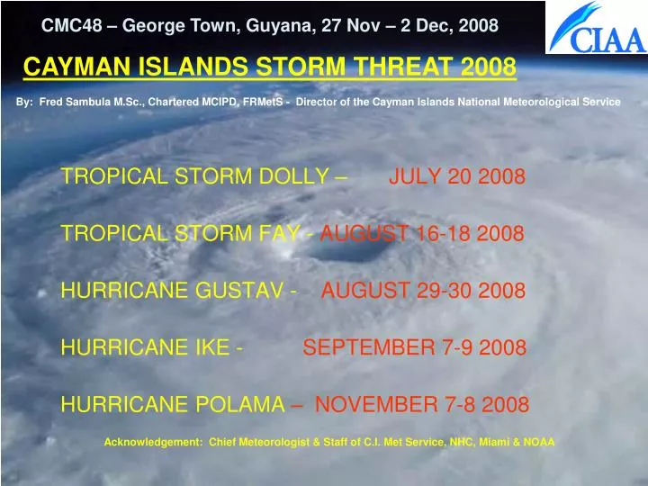
CMC48 – George Town, Guyana, 27 Nov – 2 Dec, 2008 CAYMAN ISLANDS STORM THREAT 2008. By: Fred Sambula M.Sc., Chartered MCIPD, FRMetS - Director of the Cayman Islands National Meteorological Service. TROPICAL STORM DOLLY – JULY 20 2008 TROPICAL STORM FAY - AUGUST 16-18 2008

E N D
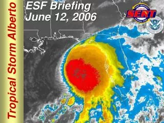
CMC48 – George Town, Guyana, 27 Nov – 2 Dec, 2008 CAYMAN ISLANDS STORM THREAT 2008 By: Fred Sambula M.Sc., Chartered MCIPD, FRMetS - Director of the Cayman Islands National Meteorological Service TROPICAL STORM DOLLY – JULY 20 2008 TROPICAL STORM FAY - AUGUST 16-18 2008 HURRICANE GUSTAV - AUGUST 29-30 2008 HURRICANE IKE - SEPTEMBER 7-9 2008 HURRICANE POLAMA – NOVEMBER 7-8 2008 Acknowledgement: Chief Meteorologist & Staff of C.I. Met Service, NHC, Miami & NOAA
Themes or Topics to be Explored CINMS – Office Operations – Tracking of Systems & Dissemination of information to Public Operation of the Warning System Public Response Working Relation with National Emergency Management
CINMS – Office Operations – Tracking of Systems & Issue of information to Public
TROPICAL STORM DOLLY • Formed 194 miles west of Grand Cayman July 19th. • The tropical storm force winds from the system remained west of Grand Cayman, hence no Tropical Storm watch or Warning was issued. • The passage of weather was covered under Severe Weather Statements July 19-21. • The system produced cloudiness and heavy showers with an accumulation of 4.58 inches measured at the Owen Roberts International Airport July 19th and 20th.
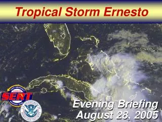
TROPICAL STORM FAY AUGUST 16-18 2008 FINAL REPORT
BIRTH OF TROPICAL STORM FAY.At 4 p.m. Friday August 15th 2008 Tropical Storm Fay: Located near 18.5 N 69.4 W or 35 miles E of Santo Domingo, Dominican Republic: Moving W at 14 mph: Maximum sustained winds near 40 mph.
TROPICAL STORM WATCH issued for the Cayman Islands.At 10 a.m. Saturday August 16th 2008 Tropical Storm Fay: Located near 19.0 N 73.7 W or 95 miles WNW of Port Au Prince, Haiti: Moving W at 15 mph: Maximum sustained winds near 45 mph.
TROPICAL STORM WARNING issued for CAYMAN BRAC AND LITTLE CAYMAN.At 7 p.m. Saturday August 16th 2008 Tropical Storm Fay: Located near 19.3 N 75.8 W or 262 miles W of Sister Islands: Moving W at 14 mph: Maximum sustained winds near 45 mph.
The Government of the Cayman Islands discontinued all WARNINGS. At 7 a.m. Monday August 18th 2008 Tropical Storm Fay was located near 23.2 N 81.2 W or NE of Veradero, Cuba. The storm was moving NNW at 12 mph with maximum sustained winds near 60 mph.
CAYMAN ISLANDS • Data from the National Hurricane Center indicate • CPA 73 miles • Maximum sustained wind speeds never reached tropical storm force. • Rainfall – 1.42 inches in Cayman Brac 7 p.m. Sunday August 17 until 7 a.m. Monday August 18
HURRICANE GUSTAV AUGUST 29-30 2008 FINAL REPORT
Tropical Depression #7 forms. At 10 a.m. Monday August 25th 2008 the depression: located near 15.5 N 70.1 W or 260 miles SE of Port Au Prince, Haiti: Moving NW at 15 mph: Maximum sustained winds near 35 mph.
Hurricane WATCH issued for the Cayman Islands.At 7 p.m. Tuesday August 26th 2008 Hurricane Gustav: Located near 18.5 N 73.3 W or 60 miles W of Port Au Prince, Haiti: Moving NW at 7 mph: Maximum sustained winds near 75 mph.
Midday, Friday, 08/29/2008 - Start TS winds in the Cayman Islands
Tropical Storm Gustav becomes a hurricane. At 4 p.m. Friday August 29th 2008 Hurricane Gustav: Located near 19.2 N 79.7 W or 100 miles E of Grand Cayman: Moving NW at 12 mph: Maximum sustained winds near 75 mph.
Hurricane Gustav moved through the Cayman Islands passing within 12 milesof Little CaymanFriday night August 29th 2008. 10 p.m. Friday August 29th 2008 Hurricane Gustav ated near 19.5 N 80.4 W or 25 miles west southwest of Little Cayman - moving northwest at 10 mph with maximum sustained winds near 80 mph. Category 1
The Government of the Cayman Islands discontinued the Hurricane Warningat 10 a.m. Saturday August 30th 2008 - Hurricane Gustav located near 21.2 N 82.1 W or 168 miles northwest of Little Cayman - moving northwest at 14 mph with maximum sustained winds near 125 mph.
IMPACT - GRAND CAYMAN • CPA 63 miles • Derived information using HURRTRAK • Maximum sustained wind speeds 56 mph gusting to 66 mph. • Higher wind speeds were likely along the north and east coasts. • Measured wind speeds • Maximum sustained wind speed measured in East End was 59 mph and 47 mph at the airport. These were measured by the Automatic weather stations installed & operated by HMCI. • Storm surge was minimal, although some flooding occurred along the coastal areas in North Sound. • The National Weather Service measured 2.71 inches RR at the Owen Roberts International Airport.
IMPACT - SISTER ISLANDS • CPA 12 miles Little Cayman; 24 miles Cayman Brac • Derived information using HURRTRAK • Maximum sustained wind speeds 82 mph gusting to 102 mph for Little Cayman; 76 mph gusting to 95 mph for Cayman Brac. • Measured wind speeds • Maximum sustained wind speed from the Cayman Brac HMCI automatic weather station 63 mph Cayman Brac; no data for Little Cayman. • Storm surge was estimated at 2 to 4 feet and wave heights of 15 to 20 feet. • Cayman Brac HMCI automatic weather station Rainfall - 9.42 inches over two days August 29/30; Little Cayman - Central Caribbean Marine Institute 6.25 inches
HURRICANE IKE SEPTEMBER 7-9 2008 FINAL REPORT
Tropical Depression #9 forms. At 10 a.m. Monday September 01st 2008 located near 17.6 N 39.5 W or 1470 E of the Leeward Islands: Moving W at 16 mph: Maximum sustained winds near 35 mph.
TD #9 strengthens to TS Ike: 4 p.m. Monday September 01Located near17.7 N 40.6 W or 1400 miles east of the Leeward Islands. TS Ike was moving W at 16 mph with max winds near 50 mph.
Ike becomes a Hurricane. At 4 p.m. Wednesday September 03rd 2008 Ike: located near 21.6 N 52.7 W or 670 ENE of the Leeward Islands: Moving WNW at 18 mph: Maximum sustained winds near 80 mph.
TROPICAL STORM WATCH issued for the Cayman Islands.At 7 a.m. Sunday September 07th 2008 Hurricane Ike: Located near 21.0 N 72.8 W or E of Great Inagua Island: Moving W at 14 mph: Maximum sustained winds near 135 mph.
TROPICAL STORM WARNING issued for the SISTER ISLANDS/Start TS winds Sister Islands.At 10 a.m. Monday September 08th 2008 Hurricane Ike: Located near 21.1 N 78.5 W or 127 miles NE of the Sister Islands: Moving W at 14 mph: Maximum sustained winds near 100 mph.
CPA Cayman Islands: 112 miles 2 p.m. Monday September 08 2008
The Government of the Cayman Islands discontinued all WATCHes and WARNINGS at 7 a.m. Tuesday September 09th 2008 - Hurricane Ike was located near 22.4 N 82.4 W or 40 miles S of Havana, Cuba - was moving WNW at 13 mph with maximum sustained winds near 80 mph.
CAYMAN ISLANDS • Data from HURRTRAK indicate • CPA 112 miles 2 p.m. Monday September 08 2008 • Actual Measurement • Maximum sustained wind speeds 38 mph. • Rainfall – 0.78 inches in Cayman Brac
HURRICANE PALOMA DEBRIEF • Life of Paloma • Impact on the Cayman Islands • Data • Pictures • Lessons Learnt
HURRICANE PALOMA DEBRIEF Life of Paloma
TD #17 forms: 4 p.m. Wed Nov 514.0 N 81.8 W or 115 miles southeast of Cabo Gracias A Dios. TD#17 was moving NW 5 mph with max winds near 30 mph
TD #17 strengthens to TS Paloma:4 a.m. Thurs Nov 615.1 N 82.2 W or 65 miles east of Cabo Gracias A Dios. TS Paloma was moving NNW at 7 mph with max winds near 40 mph.
Cayman issues Hurricane Watch: 10 a.m.,Thur, Nov 06TS Paloma located near 15.6 N 82.3 W or 265 SSW of Grand Cayman. TS Paloma was moving NNW at 7 mph with max winds near 45 mph.
6 Hours Later - Cayman issues Hurricane Warning: 4 p.m. Nov 06TS Paloma located near 16.3 N 81.8 W or 210 S of Grand Cayman. TS Paloma was moving N at 8 mph with max winds near 65 mph.
TS Paloma strengthens to A Hurricane: 7 p.m. Thurs Nov 6.Hurricane Paloma located near 16.9 N 81.7 W or 165 S of Grand Cayman. Hurricane Paloma was moving N at 12 mph with max winds near 75 mph.
Start Hurricane winds Little Cayman: 2 a.m. Saturday November 8
End Hurricane winds Sister Islands: 10 a.m. Saturday November 8
End Tropical Storm winds Cayman Brac: 3 p.m. Saturday November 8
HURRICANE PALOMA DEBRIEF • Impact on the Cayman Islands • Data
METEOROLOGICAL DATA • CPA GCM: 31 miles south – 8 p.m. Friday November 7. • CPA Little Cayman: 12 miles south – 3 a.m. Saturday November 8. • CPA Cayman Brac: 7 miles south – 5 a.m. Saturday November 8. Derived information using HURRTRAK • Max wind GCM = 68 mph gusting to 85 mph. • Max wind Little Cayman = 132 mph gusting to 165 mph. • Max wind Cayman Brac = 138 mph gusting to 172 mph. Measured wind speeds Little Cayman – No data Cayman Brac – 151 mph (90 foot tower on bluff Elev 150 ft) NRG Systems Model -Wind Explorer 9200 Grand Cayman – 42 mph gusting to 59 mph
HURRICANE PALOMA DEBRIEF • Impact on the Cayman Islands • Pictures
Impact on the Cayman Islands Pictures • Grand Cayman minimal damage to eastern districts. • Extensive damage to most wood structures and vegetation in Cayman Brac. {Estimated Cost?} • Numerous roof failures in Cayman Brac • Limited wave action related damage. • Some storm surge damage. • Rainfall totals 17.77 inches (Brac HMCI AWOS)