Download
1 / 1
10 likes | 121 Vues
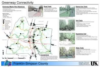
University of Kentucky. College of Agriculture. Landscape Architecture. Greenway Connectivity. Road Trails Paved lane or path along roadways Connecting corridor to other counties Minimum of 8 feet in width Utilize existing easements along road Accommodating to bikers and skaters.

E N D
University of Kentucky College of Agriculture Landscape Architecture Greenway Connectivity • Road Trails • Paved lane or path along roadways • Connecting corridor to other counties • Minimum of 8 feet in width • Utilize existing easements along road • Accommodating to bikers and skaters • Shared Use Trails • Paved path through riparian corridors and/or roadways • Provides connection between conservation areas and stream corridors • Accommodating to both bikers and walkers • Paved surfaces to provide connection between communities • Creates loop around entire county • Provides recreational opportunity for local residents and visitors to Garvin’s World • Greenway Master Plan Objectives • Connect communities with commercial and recreational destinations • Utilize riparian corridors • Encourage ecological conservation • Promote tourism and create recreational opportunities • Promote a healthier lifestyle • Features Include: • Walking/Jogging trails • Biking trails • Equestrian trails • Canoeing / Paddling trails Bowling Green Road trails can be developed by adding a lane along roadway corridors. Bowling Green Hard trail as a separate path from road with buffer area in between separating uses. Adapted from photo: picture450 [Image of bicycle lane], Retrieved April 12, 2006, from: http://www.streetprint.com/solutions/index.php Bowling Green Adapted from photo: Theroadahead [Image of roadway], Retrieved April 12, 2006, from: http://www.mikebentley.com/bike/harry/8-9.htm Legend • Soft Trails • Low impact path through forested areas and stream corridors • Accommodating for walkers and joggers • Utilizes greenway corridors • Typically composed of woodchips or grass • Interconnected by shared use trails Flat Rock Glade Nature Preserve Places of Interest Warren County Creek Access Points Communities Nature Preserve Soft Trails The Glade State Nature Preserve Road Trails 31 W Shared Use Trails Drakes Creek Pilot Knob Equestrian Trail Octagon Hall Water Trails Hillsdale Soft trail greenway through forested area. Adapted from photo: falltrail [Image of greenway trail], Retrieved April 12, 2006, from: http://www.destateparks.com/greenway/ • Equestrian Trail • Utilizes existing power line corridor • Runs directly through the heart of Franklin • Connects county from north to south between Warren County and Tennessee • Provides new type of recreation that surrounding counties do not offer which presents opportunities for tourism development Turnertown Black Jack Country Club Golf Course` I-65 To Russellville Gold City Middleton Logan County Allen County Lincoln Park Jim Roberts Park FRANKLIN Route 100 Neosheo Route 100 Equestrian trail along power line easement. Adapted from photo: trail3 [Image of equestrian trail], Retrieved April 12, 2006, from: http://www.eaglewood.on.ca/horseridingpics.htm Scottsville • Water Trails • Integrated into overall greenway system • Navigate north to south through the heart of the county on Drakes Creek • Connects to Bowling Green canoe system or south into Tennessee • Easy access through multiple launch points • Slow current for paddling of all ages Kenny Perry Golf Course Prices Mill N Red River Bornes Ford 31 W Duncan Inn Drakes Creek Connections The greenway system can provide connections to other counties. Simpson County can be connected to Bowling Green’s greenway system by utilizing the 31W corridor as well as Drakes Creek and the power line easement. Robertson County Power Line Easement Canoeing along water corridor. Adapted from photo: sCreekView [Image of Drakes Creek], Retrieved April 12, 2006, from: http://bioweb.wku.edu/faculty/ameier/drcr1.html To Nashville Franklin-Simpson County Nashville