Download
1 / 1
10 likes | 107 Vues
Explore recreational opportunities and scenic landscapes along Drakes Creek in Franklin-Simpson County with designated areas for boating, hiking, camping, and more. Enhance your outdoor experience in this serene setting.

E N D
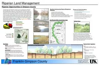
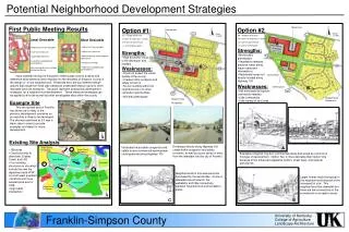
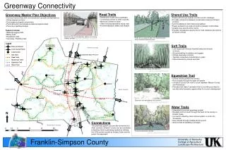
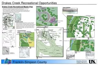
University of Kentucky College of Agriculture Landscape Architecture Drakes Creek Recreational Opportunities Drakes Creek Recreational Master Plan Drakes Creek has the potential for many recreational opportunities to be developed at access points, located at road crossings. Recreational area sites were determined by the quality of vegetation along the creek at crossings and visual water quality. Designated put-in/take-out areas for boaters were chosen by the same criteria, but located up stream and down stream in sections of Drakes Creek that holds characteristic value of the Franklin-Simpson County rural landscape. Enlarged Plan 1 Existing Old Mill Ruin Agriculture Parking Vegetation Buffer Greenway Linkages Scenic By-way Transportation Corridor Enlarged Plan 2a Salmons-Blackjack Road Entrance Drop Off Dog Park Existing Mill Riparian Areas Park Signage Park Office Hard Trails Stream access points Outdoor Accommodations Greenway Linkages *2004 NAIP aerial imagery Recreational Park The park is located at the intersection of Salmons-Blackjack Road. and Sportsman Lake Rd. This location was chosen because of proximity of downtown Franklin; existing site features, such as an old mill ruin next to Drakes Creek and favorable topography around the creek to accommodate put-in/take-out areas for boating recreation. There is also a large existing woodland that could support other outdoor activities such as camping and hiking. Soft Trail Crosswalks Picnic Areas See Enlargement 2b Information Designated Beech Access Scale: 1”=20’ Old Mill Recreational Park North North Parking Not to scale Site Analysis Soft Trails within 100 ft. of stream To Franklin Sportsman Lake Road 1 ft. Contours Conceptual Park Design See Enlargement 2a Designated Rec. Access Salmons-Blackjack Rd Sportsman Lake Rd. Agriculture Existing Mill Open Field Rec. Salmons-Blackjack Rd To Franklin Reforested Riparian Buffer Creek Access To Franklin Salmons-Blackjack Hard Trails Existing Fence Row Soft Trails Creek Recreation/Access. Vegetation buffer Picnic Areas Parking Property Lines Parking Existing Mill See Enlargement 1 Drakes Creek Trail Restrooms Day Use Drakes Creek Agriculture Farmstead Existing Farmstead Day Use Area Existing Farmstead Vegetation Buffer Scale: 1”=50’ Enlarged Plan 2b Agriculture North Agriculture Park Office Creek Access Agriculture Drake’s Creek Trail Drakes Creek Drakes Creek Picnic Areas Beach Existing Vegetation Drake’s Creek Camping Area/ Hiking Trails Existing Vegetation Soft Trails within 100 ft. of stream Agriculture Drakes Creek Soft Trail Designated Rec. Access Hiking/Camping Trails North *2004 Parcel Information Scale: 1”=300’ Scale: 1”=300’ Riparian Walking Trail Area Existing Topography North Drake’s Creek Trail Camping Areas Open Field Rec. Creek Access Existing Vegetation Picnic Areas Scale: 1”=20’ Steep Slopes +5% Loop Trail North Camping Sites Moderate Slopes -5% * Slope Analysis Agriculture *Example of trail shaded by existing vegetation. Scale: 1”=200’ North Franklin-Simpson County