Download
1 / 1
10 likes | 112 Vues
Explore riparian management guidelines, benefits, and opportunities in Simpson County to improve water quality, wildlife habitat, and ecosystem balance. Learn how to implement riparian buffers along waterways.

E N D
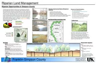
University of Kentucky College of Agriculture Landscape Architecture Riparian Land Management Riparian Opportunities in Simpson County • Benefits of Implementing Riparian Management Guidelines • Increases nearby property values • Reduces storm water/runoff flooding • Reduces bank erosion/property damage • Provides in-stream and terrestrial habitat for wildlife • Provides stream shading to promote a healthier aquatic habitat • Filters pollutions from runoff before entering the stream Sources for Future Information. The preservation of open waterways in Simpson County is an important issue identified by community stakeholders. Simpson County possesses a unique landscape that is home to many ecologically important waterways, such as Sinking Creek, a historical karst water way; Sulfur Springs; Red River; wildlife focal point Robey Swamp; and Lick Creek. Water sources in Simpson County and their quality conditions differ from location to location especially along Drakes Creek. As the largest reservoir in Simpson County as well as the public water source for the city of Franklin, Drakes Creek was chosen to due a existing conditions analysis based on the measurement of existing vegetation that is along the creek. Through this type of study locations can be identified along the creek that lack proper riparian buffers. Based on visual analysis consisting of measurements of existing vegetation, we can differentiate the existing condition into three conditions. Best conditions which consists of areas that have at least 100 feet of woodland or undisturbed vegetation on both sides. Moderate conditions consist of areas that posses approximately 75 feet of similar vegetation. And Poor conditions that only maintain 50 feet or less of woodland vegetation. • http://www.chesapeakebay.net/ • http://www.chesapeakebay.net/pubs/subcommittee • /nsc/forest/handbook.htm • http://www.crjc.org/riparianbuffers.htm • http://www.ext.vt.edu/pubs/forestry/420-151/420-151.html • http://www.soil.ncsu.edu/publications/BMPs/buffers.html • http://www.riparianbuffers.umd.edu/PDFs/FS774.pdf • http://www.oacd.org/factsheet_05.html Good Condition Ideal Riparian Buffer along Drakes Creek No Mow Zones Existing Conditions Pie Chart Good Conditions 3% 36.6% Moderate Conditions Poor Conditions Existing Vegetation 55.9% *Percentages are based on analysis of data gathered by measuring existing vegetation on aerial photography along Drake’s Creek within the Simpson County line. 1,000ft buffer Drakes Creek Moderate Condition Drakes Creek Management of riparian buffers can be approached in two ways. The first method would consist of the simple implementation of a no mow zone. The second method involves a more aggressive approach with reforestation. This method could be accomplished through donations and volunteer labor. The practice of either of these methods will result in a healthier, more attractive stream corridor. Which will promote a more diverse wildlife habitat and insure higher water quality for a more stable water source. Good Conditions Moderate Conditions Poor Conditions Saddler Ford Road Scale: NTS North *Example of aerial photo that was used to categorize condition in 2004. Poor Condition *Example of aerial photo that was used to categorize condition in 2004. Key Terms Riparian Buffer Vegetation Cross-Section of Ideal Riparian Buffer *Adapted from Chesapeake Bay Riparian Lands Handbook 2004 Riparian – complex hydrologic and ecological areas that serve as transition zones between surface water and the adjacent land . Zone 1 Native species if available. Little to no tree harvesting. Water-tolerant species. Buffer – a distinct area managed to reduce the impact of adjacent land use. Zone 2 Managed forest of fast-growing native species. Riparian Buffers – although originally developed as an agricultural BMP to preserve water quality and prevent erosion, the multifunctional quality of riparian buffers make them useful in minimizing environmental impact from a variety of land uses. Crops Pasture Zone 3 Herbaceous or grass filter strip. Stream Ideal distance or widths of buffers should be agreed on by local officials, property owners, soil conservationists, Fisheries Biologists, and other stakeholders. A buffer’s value exists not only in its ability to moderate erosion and sedimentation, but also by improving water quality, minimizing the base flow of streams, and provide a biological diverse habitat. Zone 3 Zone 2 Zone 3 Zone 1 Zone 1 Zone 2 Franklin-Simpson County