Download
1 / 46
480 likes | 731 Vues
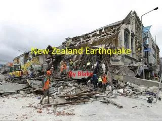
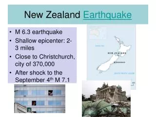
New Zealand Earthquake. M 6.3 earthquake Shallow epicenter: 2-3 miles Close to Christchurch, city of 370,000 After shock to the September 4 th M 7.1. What is the composition of lava formed on oceanic crust?. High percentages Fe, Mg Low percentages Si, O.

E N D
New Zealand Earthquake • M 6.3 earthquake • Shallow epicenter: 2-3 miles • Close to Christchurch, city of 370,000 • After shock to the September 4th M 7.1
What is the composition of lava formed on oceanic crust? High percentages Fe, Mg Low percentages Si, O
What is the source of the lava that forms oceanic crust? the mantle or asthenosphere
What is the composition of lava associated with continental crust? High percentages Si, O Low percentages Fe, Mg
The Theory of Plate Tectonics • Based on two hypotheses • Continental Drift • Seafloor spreading
Explain the development of the theory of plate tectonics in terms of the scientific method.
Observation of data or information The Scientific Method One or more ideas, statements or questions; Single or multiple hypotheses Collection of data Not accepted Hypothesis More Data Theory
Continental drift hypothesis: evidence? • Proposed in 1911 • All evidence found on the continents • Mechanism for moving the continents was not known
Continental Drift Hypothesis • Alfred Wegener proposed the hypothesis of continental drift in 1911 • He gathered information from many different sources and used it as evidence for his hypothesis
Continental Drift Hypothesis • Fit of the continents • Fossil evidence • Ancient mountain ranges • Past climate evidence Swamps formed in tropical regions Glaciers formed at the south pole
The continental drift hypothesis proposes that the continents were assembled to form the super continent Pangaea. • Moved through time 3:20
Fit of Continents • Antonio Snider-Pelligrini (1858), a geographer cut out a map of Africa and South America suggesting they were connected at one time • Other physical evidence based on observation was used by Wegener
Fossil Evidence • Similar terrestrial species were found on many continents now separated by oceans. • Information collected by paleontologists
Ancient Mountain Ranges The same sequence of rocks is found in North America, Great Brittan, and Norway. The pattern does not make sense with the continents in their current configuration.
The Appalachian Mountains Swamps 300 million years ago
Evidence of Ancient Glaciers • Glaciers carve the rock as they move. • Scientists can determine the direction of movement (notice the direction of movement noted in South America) • As South America sits today, the pattern would not make sense. (glaciers do not move from sea level to higher elevations)
Lack of mechanism to explain continental movement. • Evidence implied that the continents were at one time assembled • Wegener’s idea was not accepted by the scientific community because he could not explain how the continents moved • With advances in technology, new information was gathered in association with WWII
Exploration of the Ocean Basins • What information do you know regarding the seafloor that may be used to help understand the hypothesis of seafloor spreading?
Exploration of the Ocean Basins • Seafloor features • Composition of the seafloor • Age of the seafloor • Hot spots • Seismicity • Paleomagnetic pattern produced on the seafloor
Exploration of Ocean Basins Ocean basins contain a variety of landforms not discovered until WW II.
Support Seafloor features were discovered using sonar. • Echo sounding was used to map the seafloor 4:26
Seafloor features • Mid-oceanic ridges • Trenches • Volcanism adjacent to trenches • Seamounts • Fracture zones
Oceanic crust is composed of volcanic rock. • Basalt is volcanic rock with a mafic composition. • Higher percentages of iron and magnesium, lower percentages of silicon and oxygen. Pillow basalts
Age of Ocean Crust • Youngest at ridge • Progressively older away from ridge • Mirror image across the ridge
Seismicity • Earthquakes are concentrated at what is currently known as plate boundaries. • Explain why there are broad bands of seismicity associated with some areas.
Earth’s Magnetic Field Bipolar: acts like a bar magnet
Requirements for a magnetic field • An interior region of electrically conducting fluid such as molten metal. • Convection in that layer of fluid. • At least moderately rapid rotation.
A compass has a different declination depending on the location on the Earth’s surface
Earth’s Magnetic Field • Strength varies with location • Red- stronger • Blue weaker
Iron-rich rocks are magnetized as they cool to the current magnetic field. • Basalt= iron rich volcanic rock; oceanic crust
Paleomagnetic pattern across the mid-oceanic ridge Negative anomalies = reverse polarities Positive anomalies= normal polarities Mirror image across the ridge and correlative with age
Correlated to time Scientists dated iron-rich volcanic rocks on land Developed technology to measure the paleomagnetic reading Polar Reversals
Polar Reversals • Timescale of polar reversals • Possibly related to flow in the outer core
Paleomagnetic Evidence • Positive and negative recordings of the oceanic crust create a symmetrical pattern across the mid-oceanic trench
Seafloor Spreading • In the 1963, Harry Hess developed the idea of seafloor spreading to explain the seafloor’s formation • Continental movement is the result of ocean floor movement
Seafloor Spreading • Mafic lava is extruded along the mid-oceanic ridge to produce ocean floor. • New material is added, the cooler material is split and is “pushed” away from the ridge
Driving Mechanisms Convection cells within the mantle Push Pushing at the mid-oceanic ridges Pull Pulling at the subduction zones Convection
The theory of plate tectonics • Explains that the Earth’s lithosphere is broken into distinct units that move as a coherent package. Where the tectonic plates meet, produces distinct physical characteristics on the Earth’s surface.
The Scientific Method Observation of data or information Associated with the continents Continental Drift Hypothesis Collection of data Not accepted Ocean basins Seafloor Spreading Hypothesis Mechanism for plate movement key Theory of Plate Tectonics
Information to understand: • The evidence used by Wegener to describe the continental drift hypothesis. • The evidence associated with technology that was used to collect information about ocean basins. • The hypothesis of seafloor spreading • The accepted tectonic plate driving mechanism.
Earthquakes and volcanoes outline the tectonic plate boundaries