Download
1 / 35
380 likes | 541 Vues
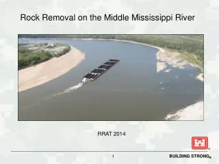
Rock Removal on the Middle Mississippi River. RRAT 2014. Navigation Channel Design. Develop a Reliable, Safe, and Environmentally Sustainable Navigation Channel on the Middle Mississippi River. 1,500 feet long. 9 feet deep.

E N D
Navigation Channel Design • Develop a Reliable, Safe, and Environmentally Sustainable Navigation Channel on the Middle Mississippi River 1,500 feet long 9 feet deep During low water periods required to maintain a 9 feet deep and a minimum of 300 feet wide navigation channel, with additional width in bends
Pools vs Open River MVS Pools 300-195 Open River 195-0
Lock & Dam #24, Clarksville, MO Pools: Impounded Mississippi River Upper River (RM 300-195)
Tools To Maintain Navigation (Open River RM 195-0) Dikes and other Rock Structures Rock Removal Revetments Weirs Dredging
Rock RemovalWhat are we trying to remove? N N MVS Mississippi River Grand Tower Thebes
Problem Statement Low Mississippi River stages will impact the St. Louis Districts’ ability to maintain the navigation channel at authorized project dimensions, in the Thebes Reach (RM 46-38) and Grand Tower Reach (RM 80-79), in the mid-December 2012. Pinnacle Rock Thebes Reach
Phase 1 Engineering AnalysisPinnacle Rock Impacts at Thebes Reach St. Louis from -5.0 to -7.0 A-Minimum C-Minimum G-Unacceptable F-Minimum B-Unacceptable D-Unacceptable E-Minimum
Rock Pinnacle Removal Phase 1 • PHASE 1: • Accomplishes a 300 ft minimum channel in 4 locations that previously had insufficient width and depth. • The resultant channel can only support 15 barge tow. Larger tows must “double-trip” or break their tow apart and take individual pieces separately through the reach. • PHASE 1 MILESTONES • 7 December 2012 – Decision made to go Urgent & Compelling • Award 2 contracts based on sources sought query (Newt & Durocher) • 7 December 2012 – Received verbal approval on Justification & Approval • 7 December 2012 – Contract award. Letter contracts 50% ROM, Newt & Durocher • 11 January 2013 – Minimum channel requirements achieved through Thebes Gage 0’ (approx -7’ STL Gage) • 29 January 2013 – Contracts definitized to include modifications • 27 February 2013 – Phase 1 Completed • 1,000 cubic yards of material was removed at a cost of $8M What Phase 1 Accomplished G A B C This what a 20 barge tow may look like trying to navigate through a 300 ft wide channel. Notice that there is no room for error considering the boxes along the channel border show additional phases of rock removal. F D E
Rock Pinnacle Removal Navigation Channel Typical view of rock formation impacting the navigation channel DSView - Rock Pinnacles near River Mile 41, Thebes, IL
Rock Pinnacles at River Mile 38.5Thebes Reach Illinois Missouri 300 ft Minimum Channel Provided Cross Section Phase 2 Rock Removal Highest Pinnacle
Cross Section at River Mile 38.5 Gage Reading (Depth after Removal) 8 Thebes (17 ft) 7 Thebes (16 ft) Current Water Level 6 Thebes (15 ft) 5 Thebes (14 ft) 4 Thebes (13 ft) 3 Thebes (12 ft) 2 Thebes (11 ft) 1 Thebes (10 ft) Water Depth at 0 Thebes (9 ft Channel After Removal) 0 Thebes (9 ft) -1 Thebes (8 ft) -2 Thebes (7 ft) Low Water Channel -3 Thebes (6 ft) -4 Thebes (5 ft) -5 Thebes (4 ft) -6 Thebes (3 ft) -7 Thebes (2 ft) -8 Thebes (1 ft) Removal Elevation -9 Thebes (0 ft) River Bed Rock Pinnacles Geometry of a cross section at RM 38.5 (Not to Scale) Water Depth at 1-29-13 0800 was 5.8 ft at Thebes
Rock Removal Methodologies • Environmental Assessment required us to “minimize the impact of the environment” 16,000 lb hydro-hammer
Rock Removal Methodologies 4.5 ton Grapple Drill & Blast
Rock Removal - Drill and Blast Method Courtesy of NWP
Rock Removal - Drill and Blast Method Courtesy of NWP
Rock Removal Phase 2 Base FY14 B C E D • 2 July – Awarded Rock Removal Phase 2 to Massman Construction for contract minimum of $1M • Includes a base and 3 option years, total contract amount$19M to remove 6,300 cy • NTP given on 27 November. • Massman on site 7 December with removal beginning on 11 December. • Locations have been prioritized to minimize the impacts to navigation during the months of December and January . • To date approximately 750 cy of material has been removed, 50% of the base contract.
Rock Removal Phase 2 ThebesRiver Miles 46-43Massman Construction A B C B D Minimum 300 feet Navigation Channel C E F D G
Rock Removal Phase 2 ThebesRiver Miles 46-43Massman Construction A B C D Minimum 300 feet Navigation Channel E F E G
Sites B, C, D, E ThebesRiver Miles 46-43Massman Construction Update (As of 2-27-2014) Hydro Hammer at C-106 Excavation at C-106
Rock Removal Phase 2 Option 1 ThebesRiver Miles 44-42Massman Construction A B C Minimum 300 feet Navigation Channel D E E F G
Rock Removal Phase 2 Option 1 ThebesRiver Miles 44-42Massman Construction A B C F Minimum 300 feet Navigation Channel D E F G
Cross Section at River Mile 38.5 Gage Reading (Depth after Removal) 8 Thebes (17 ft) 7 Thebes (16 ft) Current Water Level 6 Thebes (15 ft) 5 Thebes (14 ft) 4 Thebes (13 ft) 3 Thebes (12 ft) 2 Thebes (11 ft) 1 Thebes (10 ft) Water Depth at 0 Thebes (9 ft Channel After Removal) 0 Thebes (9 ft) -1 Thebes (8 ft) -2 Thebes (7 ft) Low Water Channel -3 Thebes (6 ft) -4 Thebes (5 ft) -5 Thebes (4 ft) -6 Thebes (3 ft) -7 Thebes (2 ft) -8 Thebes (1 ft) Removal Elevation -9 Thebes (0 ft) River Bed Rock Pinnacles Geometry of a cross section at RM 38.5 (Not to Scale) Water Depth at 1-29-13 0800 was 5.8 ft at Thebes