Enhanced Snow Analysis Methods for CFSRR Data
100 likes | 121 Vues
This study explores the integration of NESDIS IMS and AFWA snow data into the CFSRR model grid, improving daily snow analysis. By leveraging satellite imagery and detection algorithms, the CFSRR benefits from more accurate global snow depth analysis.

Enhanced Snow Analysis Methods for CFSRR Data
E N D
Presentation Transcript
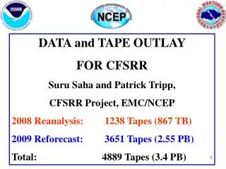
Snow Analysis for CFSRR George Gayno, Jack Woollen, Ken Mitchell, Bob Kistler FIRST CFSRR ADVISORY BOARD MEETING 7-8 NOVEMBER 2007
Background • Current GFS OPS updates snow pack once per day (00z). • SNO2MDL program maps NESDIS IMS and AFWA snow analysis data to physics grid. • Output from SNO2MDL ingested by SFC-CYCLE program. • Snow updated on model grid via direct replacement. • CFSRR will follow similar procedure.
NESDIS IMS Data • IMS – Interactive Multisensor Snow and Ice Mapping System. • NESDIS-SSD analyst uses satellite imagery and snow detection algorithms to determine snow cover over NH once per day. • Cover is yes/no flag. • 4 km resolution since Feb. 2004. • Product started Feb. 1997 (23 km resolution). • NIC in Suitland assumes responsibility for IMS starting Feb. 2008.
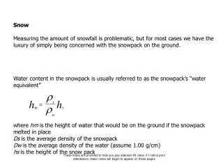
AFWA Snow Depth Data • AFWA SNODEP model produces global snow depth analysis once per day (47 km resolution). • Uses microwave-based detection algorithms, in-situ reports of snow depth, and its own climatology. • Analyst adjusts analysis based on satellite imagery in NH each day and in SH twice per week. • Product has long history. Data available for all years of CFSRR. • 1979-1998 acquired from NCDC by Mike Fennessy (COLA), who Gribbed it with help from EMC. • EMC filled some gaps and removed several “bad” analyses. • 2002 to present in Air Force non-grib format used in present ops (via EMC archive of Jesse Meng) • 1999-2001 extracted from NCO run history files.
SNO2MDL Program • Maps IMS and AFWA snow data to any GFS (or NAM) grid. • Structured around IPOLATES interpolation libraries. • Nearest neighbor or “budget” interpolation only. • If IMS indicates >50% coverage, depth set to the greater of AFWA value or 2.5 cm. • If IMS not available, depth set from AFWA data. • Will be run as pre-processing step to create T382 snow data for all days in CFSRR period. • If IMS and AFWA data missing, model will “cycle” the snow depth. • Happened for about 65 days through period.
More Information • Current IMS, AFWA, and GFS snow data may be viewed at: • http://www.emc.ncep.noaa.gov/jcsda/ggayno/home.html