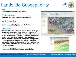
Exercise 3: Landslide susceptibility assssment using bivariate statistical analysis
240 likes | 713 Vues
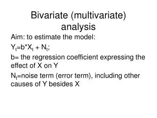
Exercise 3: Landslide susceptibility assssment using bivariate statistical analysis. Cees van Westen. Associated Institute of the. Topo DEM. High res image. Landslides. Slope angle. Slope classes. Lithology. Contour map. Weights. Active. Flowchart landslide hazard map. Input data.

Exercise 3: Landslide susceptibility assssment using bivariate statistical analysis
E N D
Presentation Transcript
Exercise 3:Landslide susceptibility assssment using bivariate statistical analysis Cees van Westen Associated Institute of the ISL 2004
Topo DEM High res image Landslides Slope angle Slope classes Lithology Contour map Weights Active Flowchart landslide hazard map Input data Statistical analysis Hazard classes ISL 2004
Input data ISL 2004
A very simple method:Information value method Wi = the weight given to a certain parameter class (e.g. a rock type). Densclas = the landslide density within the parameter class. Densmap = the landslide density within the entire map. Npix(Si) = number of pixels, which contain landslides, in a certain parameter class. Npix(Ni) = total number of pixels in a certain parameter class. ISL 2004
Generate landslide map Active1:=iff(((Activity=”a”)or(Activity=”r”))and(Part=”s”),1,0) • The analysis should be done for same type of landslides. • Here we simplify to use only Active Scarps. Active:=iff(isundef(Active1),0,Active1) ISL 2004
Step 1: Crossing the parameter maps with the landslide map ISL 2004
Step 2: Calculating landslide densities AreaAct=iff(Active=1,area,0) ISL 2004
Step 2.2: Calculate the total area in each slope class. Same value for each slope class = area of each slope class ISL 2004
Step 2.3: Calculate the area with active landslides in each slope class . Same value for each slope class = area of active landslides in each slope class ISL 2004
Step 2.4: calculate the total area in the map. Add up all area in the map = 14000000 m2 ISL 2004
Step 2.5: calculate the total area with landslides in the map . Add up all areas of landslides in the map = 213446 m2 ISL 2004
Step 2.5: calculate the total area with landslides in the map . Densclas=Areaslopeact/Areaslop Densmap=Areamapact/Areamaptot = 213446/ 14000000= 0.0152 (constant) ISL 2004
Step 3: Calculating weight values . We have too many double values in this table. We need only one result per slope class The result should be stored in an attribute table slope_cl ISL 2004
Step 3: Calculating weight values . Dclas:=iff(Densclas=0,0.0001,Densclas) Weight:=ln(Dclas/0.0152) The resulting attribute can be displayed using Map Atribute Map and table share same domain ISL 2004
Use more factor maps . Landuse Soil depth Slope classes Aspect classes Lithology Distance from river Weight maps Susceptibility map Total weight ISL 2004
Script file: automate //script for Information value method // required parameters: %1 = name of the factor map, which should be a class map del active%1.* -force del %1w.* -force //calculation in cross table Active%1.tbt := TableCross(%1,active,IgnoreUndefs) Calc Active%1.tbt //Calculate the area of landslides in the crosstable only for the combinations with landslides Tabcalc Active%1 AAct:=iff(active=1,Area,0) //create an attribute table crtbl %1w %1 //calculate the total area of landslides within each class of the factor map Tabcalc %1w Areaclassact:= ColumnJoinSum(Active%1.tbt,AAct,%1,1) //calculate the total area of the class of the factor map Tabcalc %1w Areaclasstot:= ColumnJoinSum(Active%1.tbt,Area,%1,1) //calculate the total area of landslides in the map Tabcalc %1w Areaslidetot:= ColumnJoinSum(Active%1.tbt,AAct,,1) //calculate the total area of the map Tabcalc %1w Areamaptot:= ColumnJoinSum(Active%1.tbt,Area,,1) //calculate the density of landslides in the class Tabcalc %1w dclass { vr=::0.000001}:=Areaclassact/Areaclasstot //correcting for those areas that have no landslides Tabcalc %1w densclass { vr=::0.000001}:= iff((isundef(dclass))or(dclass=0), 0.000001, dclass) //calculate the density of landslides in the map Tabcalc %1w densmap { vr=::0.000001}:=Areaslidetot/Areamaptot //calculate the weight Tabcalc %1w weight:=ln(densclass/densmap) //generating the weight map active%1:= MapAttribute(%1,%1w.tbt.weight) Show active%1.mpr %1 = parameter It will replace with name that you give in Run it: Run weight slope_cl You can also make a script that runs the script: Run weight slope_cl Run weight lithology Run weight landuse Run weight aspect_cl Etc. ISL 2004
Success rate //script for success rate calculation // one parameter %1 = weight map resulting from the statistical analysis del active%1.* -force // Cross Final with Map: active Active%1.tbt := TableCross(%1,active,IgnoreUndefs) //In the cross table, calculate tabcalc Active%1 npixact:=iff(active=1,npix,0) tabcalc Active%1 Npcumactive = ColumnCumulative(npixact) tabcalc Active%1 totalslide = ColumnAggregateSum(npixact,,1) tabcalc Active%1 totalarea = ColumnAggregateSum(npix,,1) tabcalc Active%1 percentage:=100*(Npcumactive / totalslide) tabcalc Active%1 Percentlandslide:=100-percentage tabcalc Active%1 Npixcumul:= cum(NPix) tabcalc Active%1 reverse = totalarea -npixcumul tabcalc Active%1 percentmap = 100*(reverse/totalarea) // after this display a graph with Percentlandslide az y-axis and Percentmap as x-axis Percentage of landslides Percentage of the weight map ordered from high to low ISL 2004