Experimental Long Range Flood Outlook: Understanding Production and Issuance
The Experimental Long Range Flood Outlook (LRO) is produced by River Forecast Centers (RFCs) using Run Ensemble Streamflow Prediction (ESP) methods. The process involves parsing Cooperative Streamflow (CS) data to determine the chances of exceeding minor, moderate, and major flood stages. Updates are provided monthly by the 28th, with maps reflecting the next three-month outlook. Local Weather Forecast Offices (WFOs) are responsible for verifying outlook accuracy. In case of errors, communication should be directed to the RFC or Regional Hydro Program Manager for resolution.
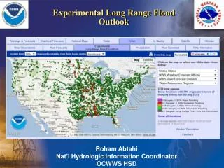

Experimental Long Range Flood Outlook: Understanding Production and Issuance
E N D
Presentation Transcript
Experimental Long Range Flood Outlook Roham Abtahi Nat’l Hydrologic Information Coordinator OCWWS HSD
How is LRO produced? • RFCs • Run Ensemble Streamflow Prediction (ESP) • Run script which parses CS data by % of exceeding minor, moderate and major flood stage • Transmits output to NIDS, who populates national level AHPS “Experimental Long Range River Flood Risk” tab • Issuance Timing • RFCs are requiredto transmit 3 month outlooks by the 28th of each month. • At 23z on the 28th, the national map switches to the next three month valid time • Can send updates as often as they like, but updates are not required
WFO Hydro Program Manager Role • WFOs • Check your local HSA to make sure long range probs look reasonable • Look for inconsistencies between color of forecast point, and actual exceedance graph of that point • What do I do if I find an error? • Call RFC and let them know – most errors will be solved at this level • Contact your Regional HPM • Submit a TOC ticket (rare case) • toc.nwstg@noaa.gov • FYI • Raw national level compilation of RFC probability data • water.weather.gov/ahps/download.php
Questions? Alaska Region: robin.radlein@noaa.gov Western Region: mike.schaffner@noaa.gov Central Region: wendy.pearson@noaa.gov Southern Region: tracy.clark@noaa.gov Eastern Region: laurie.Hogan@noaa.gov Pacific Region: No long range forecast points Me: roham.abtahi@noaa.gov 301-713-0006 ext 150