Thinking Geographically
Thinking Geographically. Chapter 1 Key Issue 1. Objective. Students will identify the fundamentals of human geography and why it is important. Key Questions : What is geography? What is human geography? What is the spatial perspective?. What is geography?.

Thinking Geographically
E N D
Presentation Transcript
Thinking Geographically Chapter 1 Key Issue 1
Objective Students will identify the fundamentals of human geography and why it is important. Key Questions: What is geography? What is human geography? What is the spatial perspective?
What is geography? List at least 5 words that come to mind when you think of geography.
Physical Geography Where and Why?
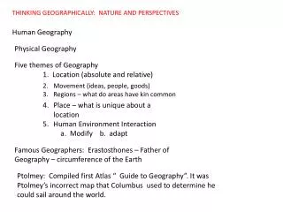
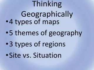
5 Themes of Geography 1. Location 2. Human-environment interactions 3. Regions 4. Place/uniqueness of place/perceptions of place 5. Movement
Objective—9/1/11-9/2 Students will examine the significance of maps and how they are used. Key Questions: What is a map? What is scale, how do we use it, and why is it significant?
Mental Map of the World • You be the cartographer (mapmaker) • 25-30 minutes • Options—make a map of anywhere! • Annapolis • Maryland • USA • North America • World • Whatever! • Include important landmarks or recognizable things on your map. Make it as accurate as possible.
You need 2 things HW: Chapter 1 Key Issue 1 To start a page of Cornell Notes
Map Comparison (Back of Map) What looks accurate on your map? What is not so accurate? What does your map tell you about the way you think? What has been your experience with maps thus far in your life?
Maps Take a look at some maps! 1. What can you learn about the region by looking at the maps? 2. What parts of the map can you identify?
Objective Students will locate places on a map mathematically. Students will identify the various types of regions Key Questions: How are latitude and longitude used? What is a region? How are people divided into regions?
Parts of a Map Latitude/Longitude
Mathematical Location • Grid of squares • Latitude • Made up of parallels—circles drawn parallel to the equator. • Equator is 0 degrees latitude. • 0-90 N latitude and 0-90 S latitude • Longitude • Made up of meridians—arcs that connect N and S poles • Prime Meridian=0 degrees longitude; runs through Greenwich, England. • 0-180 degrees East longitude and 0-180 degrees West longitude
Longitude-- Text p. 19 • Longitude is both man-made and natural • Time zones are measured by longitude • 24 time zones • Prime Meridian is at 0 degrees=Greenwich Mean Time • International Date Line is at 180 degrees—Moves clock back 24 hours
Even more precise Mathematical Location also includes minutes and seconds 60 minutes (Written as ‘ ) 60 seconds (Written as “ )
Parts of a Map • Scale—Depends on the detail and amount of land covered. • Large-scale—More detail, less area shown • Example: Annapolis • 1:25,000 • Small-scale—Less detail, more area shown • Example: Map of US • 1:500,000
Scale • Scale is written 3 different ways: • Written: • Ratio: 1:50,000 • Fractional: 1/50,000 • Graphic:
1:50,000 • The first number refers to the distance on a map. • 1 inch, 1 cm, 1mm • The second number refers to the number of the same unit. • 50,000 inches, 50,000 cm, 50,000 mm • In other words: 1 inch on the map equals 50,000 inches on the surface of the Earth.
Textbook p. 434-435 • Work with some people around you. • Label the distances in miles (approximately) between the following locations: • Los Angeles to New York • Washington, D.C. to Bogota, Colombia • Johannesburg, South Africa to Moscow, Russia • Beijing, China to Madrid, Spain
Brief History of Geography Aristotle—First to demonstrate the Earth was spherical. Eratosthenes—200 B.C. First to use the word “geography.” Figured out the circumference of the world with 99% accuracy. Ptolemy—Ancient Greek cartographer.
Cartography Today • Geographic Information System (GIS) • Stores information in layers • Navigation layers: weather, traffic, parking.
Cartography Today • Global Positioning Systems (GPS): • Collects information from 2 dozen satellites using remote sensing. • Satellites and receivers track position, velocity, and time.
Exit Ticket! 3) 1:24,000 is an example of what kind of scale? A) bar line B) metric scale C) graphic scale D) written scale E) fractional scale 4) If the scale of a map is 1:24,000, then 1 inch on the map represents ________ FEET on Earth's surface. A) 1 B) 2,000 C) 2,400 D) 24,000 E) 240,000 5) Which map would have the smallest scale? A) world B) continent C)state D) city E) county
Objective Directions: (Don’t copy directions) Objective—Students will examine the differences between various places on Earth. How is every place on Earth unique? How do we use site, situation, toponyms, latitude and longitude to identify places around the world?
Every place is unique How do we identify places on Earth?
Every place is unique Toponyms—Place Names Site Situation Mathematical Location
Toponyms—Place names How do places get their names?
Toponyms—Place names • How do places get their names? • Founders • Washington, Lincoln, St. Louis, St. Paul, Elias Glenn • Significant events • Lucky Boy Pass, Intercourse, PA. • Origins from the founding country • New York, New Jersey, New England, San Diego, Los Angeles • Description • Llanfairpwllgwyngyllgogerychwyrndrobwllllantysiliogogogoch: • The church of St. Mary’s in the grove of the white hazelnut tree near the rapid whirlpool and the church of St. Tisilio near the red cave.
Site • Site—physical characteristics like climate, water sources, topography, soil, vegetation, latitude and elevation. • What you SEE! • What makes a good site for settlement? For protection? For transportation? • People can change a site’s characteristics:
Situation • Situation is the location of a place in relation to other places. Important for 2 reasons: • 1) You can compare locations to others. • Where is SMHS? Off 97, on Spa Creek, Downtown. • 2) You can understand the importance of a location. • Trade Routes, travel stops, etc.
Postcard 30 minutes
Review • 1. Site identifies a place by its A) location relative to other objects. • B) mathematical location on Earth's surface. • C) nominal location. • D) unique physical characteristics. • E)primary dimensions. 2. The name given to a portion of Earth's surface is known as A) location. B) site. C) situation. D) toponym. E)jargon. • 3. New York City's ________ is approximately 100 miles northeast of Philadelphia and 100 miles southwest of Boston. • A) location • B) site • C) situation • D) toponym • E) jurisidiction
Cultural Landscape Define-
Regions • An area of earth distinguished by one or more unique characteristics • Formal regions- homogeneous, everyone shares one or more distinct characteristic • Examples: • Functional Regions – (Nodal Regions) begins at core and moves outward. • Examples: • Vernacular Regions – a place that people believe exists as part of their cultural identity. Geographers refer to culture here • Examples:
How do regional definitions help us organize and understand the country and the world? Which types of regions contribute to stereotypes most? Why?
Functional Region/Nodal Washington Post distribution area hearth
Objective • Objective: Students will analyze the various aspects of culture and how culture diffuses. • Drill: Copy the question and the correct answer. • 1. The spread of various aspects of culture, such as language, knowledge, skills, religion, etc., from one place to another is called: • A. distribution • B. relocation • C. diffusion • D. infection • E. hierarchy
Culture List one word that comes to mind when you think of culture.
What people care about Languages Religion Ethnicity
What People Take Care of Food Clothing Shelter
What people take care of • More Developed Countries (MDCs) • Less Developed Countries (LDCs) • Measured by per capita income, literacy rates, TVs, hospital beds per capita
Cultural Ecology • How humans interact with their environment • Environmental determinism – environment causes social development. • Example: Climates and landforms