Download
1 / 11
110 likes | 291 Vues
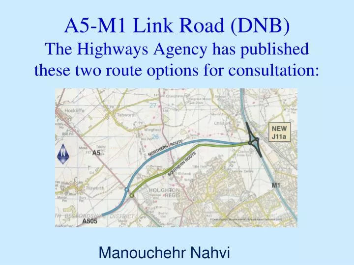
A5-M1 Link Road (DNB) The Highways Agency has published these two route options for consultation:. Manouchehr Nahvi. The Two Bypass Options. Southern Route : Safeguarded Route in South Beds Local Plan Northern Route:

E N D
A5-M1 Link Road (DNB)The Highways Agency has published these two route options for consultation: Manouchehr Nahvi
The Two Bypass Options • Southern Route: • Safeguarded Route in South Beds Local Plan • Northern Route: • An alignment further north designed to create more potential for development
Development issues • The GVA Grimley study commissioned by the HA to assist evaluation of the effect of potential development of the Bypass proposal, considered 3 development options for 2 different bypass alignments
The Three development Options • Development south of the Southern Route • Development both sides of the Southern Route • Development south of the Northern Route
The GVA Grimley Study estimated the following scale of housing that might be accommodated: • Development both sides of the Southern Route • Up to 17000 units • Development south of the Northern Route • Up to 16000 units • Development south of the Southern Route • Up to 11000 units
The SBDC perspective:Key Issues • The primary purpose of the route should be strategic, and with the aim of maximising traffic relief for Dunstable • Need to ensure that the Bypass design can fully accommodate both strategic A5/M1 traffic and: • connections to the proposed Luton Bypass and the A505; • access to proposed new development area • a new link road to connect to the central Dunstable and Houghton Regis employment area; • The Northern Route could provide more flexibility in respect of the above points • SBDC to continue ‘In principle’ support for the scheme
Environmental implications • Both bypass routes are predicted to: • reduce HGV traffic through Dunstable • slightly reduce traffic congestion in central Dunstable • help improve air quality in the urban area • However, they also have: • some adverse ecological and landscape impact • potentially significant archaeological impact • significant impact on the rights of way network
Land use • Land take is similar for both options, with nearly 40% associated with the proposed junction with the M1 . • Both routes require the same number of properties to be demolished at the eastern end of the Bypass • The Southern Route will have further impact, taking approximately 38% of the Rugby Football Club.
Visual and landscape impact • The most significant visual and landform effect will be from junction 11A • Northern Route will have greater landscape impact than Southern Route
Indicative Scheme Programme • Public Consultation • Sept to Dec. 2005 • Preferred Route announcement • Late Spring 2005 • Draft Order publication: 2007 • Public Inquiry: 2008 • Start of Works: 2009 • Open to traffic: 2010/11
Conclusion • It is recommended that the Council responds to the HA consultation in the terms listed under paragraph 2.0 of the report.