ORNL DAAC Spatial Data Access Tool (SDAT):
National Aeronautics and Space Administration. ORNL DAAC Spatial Data Access Tool (SDAT):. Internet tools to access and visualize land-based data. www.nasa.gov. What is SDAT.

ORNL DAAC Spatial Data Access Tool (SDAT):
E N D
Presentation Transcript
National Aeronautics and Space Administration ORNL DAAC Spatial Data Access Tool (SDAT): Internet tools to access and visualize land-based data www.nasa.gov
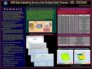
What is SDAT • Web-based tool that enables users to browse, visualize and download geospatial data in various user selected spatial/temporal extents, formats, and projections • Data include selected ORNL DAAC Archived Data Sets as well as other biogeochemical dynamics related data (Land Cover, Elevation, Climate Classification, Ecoregions, and Soils). Tammy Walker Beaty
About SDAT • Provides access to various geospatial data through Open Geospatial Consortium (OGC) standards-based Web Services • Web Map Service v1.1.1 • Web Coverage Service v1.0.0 • Two levels of tool features • Data Set Level • Data File (granule) Level Tammy Walker Beaty
SDAT Landing page – Data Set Level Functions, interface to Granule Level Functions • http://webmap.ornl.gov/wcsdown/ • Visualize Data Set – automatic function • Visualize in Google Earth • View Metadata • Proceed to file/granule level download options • Projection • Resolution • Format • Time • Bands • Interpolation Method • Spatial Extent Tammy Walker Beaty
Demo: AVHRR Land Cover Examplehttp://webmap.ornl.gov/wcsdown/ Tammy Walker Beaty
Additional Slides – Available Data in SDAT Tammy Walker Beaty
ORNL DAAC Archived Data Sets in SDAT • Amazon River Basin Precipitation Data, 1972-1992 • BIGFOOT Leaf Area Index Surfaces for North and South American Sites, 2000-2003 • Global 30-Year mean Monthly Climatology, 1930-1960, V.2.1 (Cramer & Leemans) • Global Data Set of Derived Soil Properties, 0.5-Degree Grid (ISRIC-WISE) • Global Distribution of Plant-Extractable Water Capacity of Soil (DUNNE) • Global Maps of Atmospheric Nitrogen Deposition, 1860, 1993, and 2050 • Global Soil Types, 0.5-Degree Grid (Modified Zobler) • Phenoregions for Monitoring Vegetation Responses to Climate Change • SiB3 Modeled Global 1-degree hourly Biosphere-Atmosphere Carbon Flux, 1998-2006 Tammy Walker Beaty
Data Archived From Other Sources in SDAT Land Cover • MCD12Q1 Land Cover Product (Land Cover Types 1-5) – LPDAAC • MODIS MOD12C1 0.25 Degree Land Cover – Boston University • MCD12Q1 Land Cover Product – LP DAAC • 8 km Global Land Cover Data Set Derived from AVHRR - GLCF, UMD • National Land Cover Database 2001 (NLCD) – USGS/EROS • Global and Regional Land Cover Maps, 2000 – European JRC • Global Distribution of Cultivation Intensity at 1 Degree X 1 Degree Resolution – • USDA NASS Cropland Data Layer (CDL) – NASS • Forest Biomass Across the Lower 48 States and Alaska – USFS Tammy Walker Beaty
Data Archived From Other Sources in SDAT Elevation • Global 30 Arc-Second Elevation Data Set (GTOPO30) – • Shuttle Radar Topography Mission (STRM) Near-global Digital Elevation Models (DEM) – Ecoregions • Bailey Ecoregions Map of the Continents – NOAA Climate • World map of the Koppen-Geiger Climate Classification – PI Tammy Walker Beaty