Download
1 / 74
750 likes | 1.19k Vues
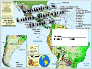
Unit 3 Latin America. Chapter 8. The Physical Geography of Latin America A. The Land 1. The Americas and the Caribbean a. Divided into 3 areas 1. Middle America (Central) a. Seven countries. 2. Caribbean a. Also known as the West Indies

E N D
Chapter 8 • The Physical Geography of Latin America A. The Land 1. The Americas and the Caribbean a. Divided into 3 areas 1. Middle America (Central) a. Seven countries
2. Caribbean a. Also known as the West Indies 1. Bahamas 2. Greater Antilles 3. Lesser Antilles 3. South America a. Includes 13 countries
2. Mountains, Plateaus and Hills a. Terrain is diverse 1. Rainforest and Andes dominate b. Mountains 1. Mexico a. 2 ranges 1. Sierra Madre Occidental 2. Sierra Madre Oriental
2. South America a. Andes Mtns. 1. 4500 miles long 2. World’s longest mtn chain 3. 2nd highest (20,000 ft)
b. Brazilian Highlands 1. drops sharply to the Atlantic a. Forms an escarpment 1. slope or cliff
c. Plateaus and Hills 1. flat highlands used for grazing 2. Patagonia a. Southern Argentina
Plains Areas a. Along Gulf of Mexico b. Atlantic coastline of NE S. America c. Pacific coastline d. Includes: 1. llanos a. Large, fertile areas along the Caribbean coast 2. Pampas a. Grassy, treeless plains of Argentina and Uruguay
Rivers, Lakes and Waterfalls a. Rivers 1. Amazon a. Longest river in W. Hemisphere b. Largest volume of water in the world
2. Rio de la Plata a. Formed by Parana, Paraguay and Uruguay rivers b. 2nd largest system in S. America
b. Lakes and Waterfalls 1. S. America does not have many large lakes 2. Angel Falls a. World’s highest waterfall 1. drops 3212 ft.
Natural Resources a. Energy 1. oil and gas a. Mexico is 5th largest oil producer 2. Waterfalls and rivers enable hydroelectric power. b. Minerals 1. Bauxite (aluminum), copper, tin and silver.
Climate and Vegetation 1. Climate Regions a. Most of L.A. in low latitudes 1. Between Tropic of Cancer and Tropic of Capricorn b. Tropical Climates 1. Tropical Rain Forest a. hot temp, lots of rain year round. b. Amazon Basin, Caribbean Islands, S. Mexico, E. South and Central America 2. Tropical Savanna a. hot and wet, but not all year. b. Most of Central America, parts of Columbia, Venezuela, Brazil, Bolivia and Paraguay.
c. Humid Subtropical Climate 1. much of SE South America 2. winters short and mild 3. summers long and humid d. Desert climate 1. hot and dry most of the time 2. Atacama Desert a. One of driest places on earth
c. Steppe Climate 1. hot summers, cold winters, some rain. a. North Mexico, some highlands d. Highland Climate 1. along mtns and Andes. 2. arranged vertically by altitudes a. Tierra caliente 1. lowest altitude 2. means “hot country” b. Tierra templada 1. means “temperate country” c. Tierra fria 1. means “cold country”
2. Vegetation a. Consists mostly of rain forests and grassland b. Tropical Rain Forests 1. mostly around Equator 2. Amazon Basin – largest a. 1/3 of South America b. Includes canopy that prevents sun from reaching forest floor. c. More kinds of trees and animals than any other place on earth.
c. Grasslands and Deserts 1. llanos and pampas a. Short clumps of grass b. Scattered trees 2. deserts a. Very few plants d. Vertical climate zones 1. vegetation is varied 2. coffee often grown
Rainforest Facts • The Amazon Rainforest covers over a billion acres, encompassing areas in Brazil, Venezuela, Colombia and the Eastern Andean region of Ecuador and Peru. If Amazonia were a country, it would be the ninth largest in the world. • More than 20 percent of the world’s oxygen is produced in the Amazon Rainforest. • More than half of the world's estimated 10 million species of plants, animals and insects live in the tropical rainforests. • One-fifth of the world's fresh water is in the Amazon Basin. • At least 3000 fruits are found in the rainforests; of these only 200 are now in use in the Western World. • The U.S. National Cancer Institute has identified 3000 plants that are active against cancer cells. 70% of these plants are found in the rainforest.
A B
The Cultural Geography of Latin America A. Population Patterns 1. Human Characteristics a. 500 million people live in Latin America 1. 9% of world’s pop. b. Ethnic Diversity 1. Native American a. Mayans b. Incas c. Aztecs
2. Europeans arrived in 1400s 3. Africans arrived in 1500s a. Slaves 4. Asians arrived in 1800s a. servants
c. A Blending of Peoples 1. Mestizos a. Mixed Native American and European descent 2. Mulattoes a. Mixed African and European descent
d. Language 1. Countries adopted languages of people that colonized there. a. Brazil – Portuguese b. Haiti – French c. Jamaica - English 2. Spanish official language of most countries today 3. Dialects – forms of language peculiar to a particular place or region 4. Native American a. Spoken by millions b. modern day Spanish is mixed with Native American words
2. Population Density and Distribution a. Multicultural b. Population Distribution 1. most of pop. Lives on 1/3 of land a. Along coasts 1. called “population rim” 2. 66% live in South America a. 331 million 3. Central America b. 132 million
A B
c. Population Density 1. Mexico- most populated Spanish speaking country in world a. 132 people/square mile 2. Caribbean – countries are small a. High birth rate b. Land not suitable for farming 3. South America a. Density is quite low 4. people live where farming is suitable
d. Urbanization 1. one way migration a. Many move to cities for jobs b. Creates slums 1. lack of resources 2. The Cities a. Most Latin American nations are urbanized b. Cities that rank among top 15 largest in world 1. Mexico City, Mexico 2. Sao Paulo, Brazil 3. Rio de Janeiro, Brazil 4. Buenos Aires, Argentina
3. Push and pull factors drawing people towards the cities a. push poor medical care, poor education, low-paying jobs, few own land b. pull higher-paying jobs, better schools, better medical care
History and Government 1. Native American Empires a. Originally came across Bering Strait b. 3 major empires: 1. Maya a. Central America/Southern Mexico – Yucatan Peninsula b. Pyramid shaped temples and courts c. Skilled in Math 1. used number system 2. concept of zero d. Created 365 day calendar
Extent of Mayan Culture Mayan culture extended from Southern Mexico into Central America
d. The Aztec 1. built a permanent capital at Tenochtitlan (present day Mexico City) 2. grew crops on Chinampas – floating artificial islands 3. developed complex political system a. Headed by emperor 4. worshiped many gods
A B
e. The Inca 1. empire stretched along Andes 2. created central government a. Emporer 3. excellent farmers a. Cut terraces into slopes b. Built irrigation systems c. Domesticated alpacas and llamas 4. Built temples and fortresses 5. no written language 6. sent messages with quipu a. Rope with knotted cords of various lengths and colors.
12 November 2009 Get your notes out and prepare for the quiz Pop goes the quiz
2. European Empires a. Were looking for new trade routes b. Spain and Portugal were first to fight over lands in Americas. 1. line of Demarcation a. Pope drew imaginary line from N. Pole to S. Pole. 1. lands east – Portugal 2. lands west - Spain
c. Spanish Conquests 1. search for trade turned into search for riches. a. Spanish wanted to convert Natives to Christianity. 2. Conquistadors overpowered Aztecs and Inca empires.