NYC Watersheds
NYC Watersheds. Homework comments. Office hours today and Wednesday Equations: solve first using symbols. Substitute numbers (with units) as the last step Make sure you answer all parts of every question Work in teams! Each person should attempt the homework before meeting together


NYC Watersheds
E N D
Presentation Transcript
Homework comments • Office hours today and Wednesday • Equations: solve first using symbols. • Substitute numbers (with units) as the last step • Make sure you answer all parts of every question • Work in teams! • Each person should attempt the homework before meeting together • Final solution should be checked by a different team member than the person writing the solution • This will eliminate careless mistakes!
Overview • Quantity of water needed by NYC • Potential sources of water • ______________ • ______________ • ______________ • _____________ • History of NYC water supply • wells • Croton • Catskills/Delaware groundwater ocean streams rainfall
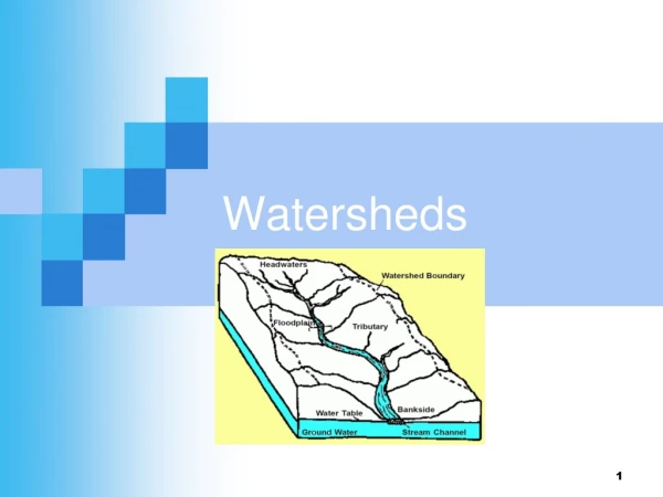
NYC Watersheds: Introduction • NYC needs 61 m3/s • How much land is needed to deliver that much water? • How do you choose which land to use for watersheds?
NYC Water Supply Strategy • Choose streams to meet 4 criteria • _________ • _________ • _________ • _________ • Build dams on streams to provide storage (reservoirs) • Build aqueducts to carry the water from the reservoirs to NYC Quantity Quality Altitude Proximity
Land Area Required for NYC Watersheds (The Big Picture) • Where does the water in the streams come from?___________ • How could we estimate the average stream flow? • ______________________ • ______________________ Precipitation Rain gage Direct stream measurements
Data Requirements for Predicting Stream Flows • Precipitation • Will need to use rain gage data from site close by • US climate data • Evaporation/Transpiration • Evaporation data may be available for lakes • Evaporation and Transpiration are strongly affected by • Type of vegetation • Ground cover • Temperature • Wind • _____________ Season
Annual Precipitation at Poughkeepsie NY Snow year (July to June)
Annual Precipitation at Poughkeepsie NY 40 year record Precipitation cm Lowest year: 66 First quartile: 92 Median: 106 Third quartile: 115 Highest year: 137 Mean: 103 For comparison, Binghamton’s mean precipitation is 94 cm/year
Land Area Required for NYC Watersheds: Detail Approach • Measure the stream flow over time in potential watersheds • United States Geological Survey • USGS home page • The National Atlas of the United States of America • Calculate the annual water yield per watershed area (cm/year)
Stream Flow Vs. Precipitation Poughkeepsie Walton, NY Snow year (July to June)
Why is Correlation Between Precipitation and Stream Flow so Poor? • Stations are too far apart • Evapo-transpiration changes with land use • Time lag between precipitation andstream flow
Stream Flow vs. Precipitation Estimates for the Catskills • Approximately _____ of the rainfall leaves the watershed as stream flow • The majority of the remaining rainfall leaves the watershed as transpiration/evaporation • A small amount of water leaves the watershed as _________________ 60% ground water flow
Annual Stream Flow at Walton NY Stream Flow (cm/yr) Lowest year: 27 First quartile: 53 Median: 58 Third quartile: 70 Highest year: 92 Mean: 60
(Area - A) ^ Drought Year Watershed Sizing • Estimate the Watershed size required for NYC based on: • 61 m3/s demand • Drought-year stream flow of 27 cm/yr (flow rate - Q) (Velocity - V) Q=VA A=Q/V = 7130 km2
Analysis Assumptions • Reservoirs can store water to even out flow throughout a year • We assumed drought intensity is same in all NYC watersheds • We assumed all watersheds have same drought ___________ • What about NYC’s ability to ____________ __________ during a drought? stream flows reduce water consumption
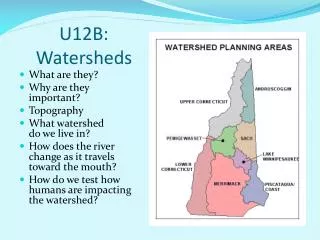
NYC Watersheds: Croton and Catskill • Croton system (1842) • 12 reservoirs and 3 controlled lakes • 960 km2 of watershed • _____ of the City’s drinking water • Catskill system (1927) • 2 source reservoirs • 1461 km2 of watershed • _____ of the City’s drinking water 10% 40%
NYC Watersheds: Delaware and Total system • Delaware system (1965) • 4 source reservoirs • 2585 km2 of watershed • _____ of the City’s drinking water • Total System • 5000 km2 of watershed • our estimate: 7130 km2 MAP 50%
Summary • We found how much land NYC needs to supply their water based on stream flow data • We found where the land is located and saw where the reservoirs are located • Coming up… • How big do the reservoirs have to be to provide adequate storage? • How does the water get from the reservoirs to NYC?
Catskill/Delaware Watersheds Schoharie Cannonsville Pepacton Ashokan Rondout Neversink