Download
1 / 16
160 likes | 340 Vues
Watersheds. Reading: Discussion: issues facing Arizona’s rivers Lecture: How you identify a watershed Why are they important Activity: Using tributaries to find a watershed boundary. River Networks. Contour Lines. Drainage Divides. Reynolds and Johnson.

E N D
Watersheds • Reading: • Discussion: issues facing Arizona’s rivers • Lecture: • How you identify a watershed • Why are they important • Activity: • Using tributaries to find a watershed boundary The University of Arizona
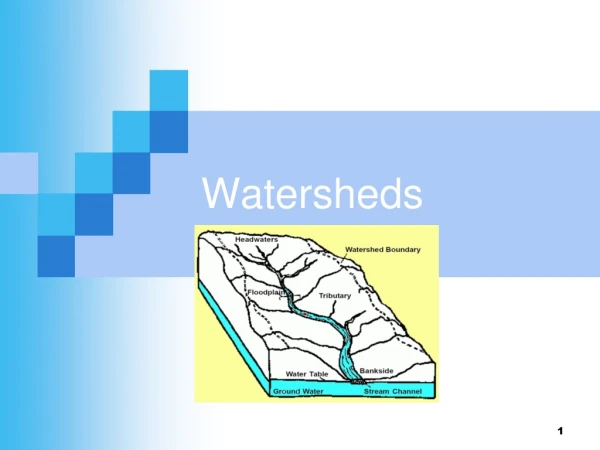
River Networks Contour Lines Drainage Divides Reynolds and Johnson boto.ocean.washington.edu/gifs/purus.gif What separates watersheds? How do you identify watershed boundaries? The University of Arizona
Drainage Divide http://www.alpinezone.com/hiking/01images/older/KNIFEDGE.jpg Drainage Basin • A region or area bounded by a drainage divide and occupied by a drainage system; • specifically, the tract of country that gathers water originating as precipitation and contributes it to a particular stream channel or system of channels, or to a lake, reservoir or other body of water. • The original meaning of the term signifies a “water parting” or the line, ridge, or summit of high ground separating two drainage basins. The University of Arizona Source: Glossary of Geology, 3rd Ed.,1987, AGI
Watershed Definitions • A region draining into a river or lake (American Heritage Dictionary) • The area that produces runoff to a downstream point (Handbook of Hydrology) • The area contained within a drainage divide above a specified point on a stream (Dictionary Of Geologic Terms) • The upstream area that can contribute runoff to a point below. • A drainage basin that divides the landscape into hydrologically defined areas. (Environment Canada) The University of Arizona
http://www.nationalatlas.gov/Images/condivm.gif The Continental Divide is a line separating waters that flow into the Atlantic Ocean or Gulf of Mexico from those that flow into the Pacific Ocean. It runs north-south along the crest of the Rocky Mountains (in Mexico and Canada too) and is sometimes called the Great Divide. This map layer was compiled by the U.S. Geological Survey by extracting the appropriate lines from the Hydrologic Unit Boundaries layer of the National Atlas. The University of Arizona www.nationalatlas.gov/ condivm.html
Watershed - Importance 1. Understand what a watershed is both literally and conceptually (including the mapped representation of a watershed and the issue of scale). 2. Understand the components and processes of a watershed including runoff, soil, geology, geography, permeability, storage, land cover, land use, vegetation, precipitation, stream flow, flooding, drought (climate), fire, drainage patterns, erosion, deposition and population. 3. Understand a watershed as a system (e.g. a change in one area will affect the dynamics of the entire system) and how that system functions. 4. Understand that watershed management is complex because of culture, economics, politics, social constructs, scientific studies and aesthetics. Some water users include urban, rural, agricultural, business & industry, energy, recreation, fish and wildlife and earth systems. 5. Understand that watersheds change over time both naturally (e.g. flooding, fire) and due to anthropogenic causes (e.g. damming a river, water rights, water withdrawals). 6. Know some of the issues facing the watershed managers of the Colorado River Watershed as well as other Southwestern Watersheds. The University of Arizona
The drainage pattern allows you to understand the watershed boundaries and directions of stream flow even without topography The University of Arizona
… although a shaded DEM helps! The University of Arizona
Seeing Watersheds Activity 1: trace the main channel of the river from its mouth to the headwaters. 2: trace the major tributaries (start at the coast/Gulf). 3a: Find the drainage divides by marking a dot above the top of each river, midway to the adjacent watershed. 3b: Connect the dots (start at the mouth) to form the watershed boundary. 4:Identify sub-watersheds of major tributaries The University of Arizona
Synonyms: Basin Catchment Catchment Area Catchment Basin Drainage Area Drainage Basin Feeding Ground Gathering Ground Hydrographic Basin Watershed Source: Glossary of Geology, 3rd Ed.,1987, American Geophysical Institute The University of Arizona
Watershed – Sub-watershed HUC: 14-15 HUC: 1401-1508 The University of Arizona
Colorado – “source” of 4 WS’s = 8,131,000 af The University of Arizona
Major Western Rivers Strahler: 4-7 The University of Arizona
Columbia Yellowstone Missouri Snake Klamath Sacramento Platte San Joaquin Colorado Rio Grande Gila Major Western Rivers ag.arizona.edu/watershed/ The University of Arizona
Contributing Area Upper Basin • CO • WY • NM • UT Lower Basin • AZ • NV • CA The University of Arizona
CRB Analysis The University of Arizona