Download
1 / 28
280 likes | 311 Vues
Learn the significance of watersheds, how pollutants enter water bodies, and methods for determining slopes and drainage areas. Discover watershed protection strategies and how to read contour maps. Practice delineating watersheds and subareas for improved water management. Utilize helpful tips and software programs for mapping and data collection. Enhance your knowledge of watershed conservation and contribute to a sustainable environment.

E N D
Outcomes • Read a contour map • Delineate a watershed • Determine slopes/lengths • Determine a drainage area
We All Live in a Watershed When water runs off your property where does it go?
Importance of Watersheds • Pollutants can enter waterbodies • Silt from construction sites, farms, erosion • Septic system waste • Fertilizers, pesticides • Road salt • Other pollutants (industry/commercial)
Watershed Protection • SPDES (stormwater pollution discharge and elimination system) • Watershed action plans • Public Involvement (stewardship)
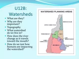
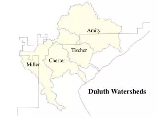
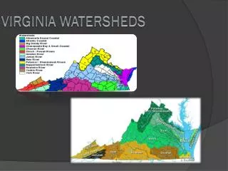
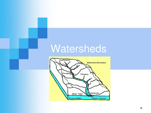
Watershed • Any particular point on a water channel (stream, ditch, gutter, etc.) has an associated watershed area • The boundaries of a watershed are ridge lines (high points) • You can identify ridge lines by contour lines on topographic maps
Hints for reading contour maps • Flow paths are perpendicular to contour lines (why?) • Streams---Contour lines are concave (think V’s) • Ridges----Contour lines are convex (think noses) • Peaks of mountains and depressions (swamps, ponds) usually show as small circular areas • Contour lines close together indicate steep slopes • Contour lines which are far apart indicate flat slopes • Highlight rivers/creeks to your point of interest (it also sometimes helps to highlight them outside your point of interest) • Ignore roads; ideally, any construction project shouldn’t shift water to another watershed
Steps-Delineating Drainage Areas • Identify your point of interest • Identify the channels/subchannels (V’s) • Identify the hill tops (circles) • Draw from hill-top to hill-top along the ridges (noses)
Delineate Watershed • Class Exercise (Handout Figure II-1) • Spend 5 minutes delineating watershed
Sub-Drainage Areas • Drainage areas may be broken up into sub-catchments or sub-drainage areas because: • Drainage areas are usually modeled as homogeneous systems • Streams are branched • Points of interest need to be isolated
Delineate Subareas Class exercise Spend 5 minutes delineating subareas for each reach Handout answers (Figure II-2 and II-3)
Determining Drainage Areas • Stripping Method • Grid Method • Planimeter • Software Programs (GIS)
Stripping/Grid Methods http://www.globalsecurity.org/military/library/policy/army/fm/5-430-00-1/fig6-13.gif
Software http://gis.esri.com/library/userconf/proc99/proceed/papers/pap676/p6764.gif
Determining Lengths Edge of Paper Tic Method String Method (non-stretch string) Don’t use “as the crow flies” Check scale (1”=2000’ or other) 20
Data Collection • Land Use • Soil Characteristics • Slope (overland and channel) • Channel/Overland flow lengths • % Impervious • Channel cross-sections • Roughness characteristics • Storage (ponds, swamps, wetlands)
Sources • Field reconnaisance • Aerial Photographs • NRCS Soil Maps • USGS Maps/Other Contour Maps • Planimetric mapping • Historical engineering studies • Survey Data • Soil Boring Data
Common Conversions • 1 acre = 43,560 ft2 • 1mi2 = 640 acres • 1 hectare = (100 m)2 = 10,000 m2 • 1 acre = 0.405 hectare • 1 hectare = 2.46 acres • 1 meter = 3.2808 feet • 1 foot = 0.3045 meter
Downloading USGS Maps *.pdf http://store.usgs.gov/b2c_usgs/b2c/start.do
Other tools: • Image capture software: • Snipping Tool (on engineering computers) • In adobe reader use tools, select and zoom, snapshot tool, to capture images • USGS pdf’s---click on images, click off orthoimages to turn off the background photogrammetry
Streamstats https://water.usgs.gov/osw/streamstats/
Other Sources NRCS pdf – determining watershed http://www.epa.gov/owow/watershed/ http://www.dec.ny.gov/lands/25563.html
Next Lecture • Precipitation • Definition • What affects it? • Return period • Probability of an event occurring over a time interval • Design Frequencies • IDF Curves