Download
1 / 1
10 likes | 98 Vues
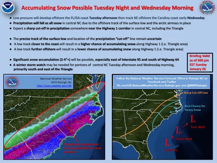
Accumulating Snow Possible Tuesday Night and Wednesday Morning. Briefing Valid as of 500 pm EST Sunday January 26. Sharp Cut-Off Line. ● Low pressure will develop offshore the FL/GA coast Tuesday afternoon then track NE offshore the Carolina coast early Wednesday

E N D
Accumulating Snow Possible Tuesday Night and Wednesday Morning Briefing Valid as of 500 pm EST Sunday January 26 Sharp Cut-Off Line ● Low pressure will develop offshore the FL/GA coast Tuesday afternoon then track NE offshore the Carolina coast early Wednesday ● Precipitation will fall as all snow in central NC due to the offshore track of the surface low and the arctic airmass in place ● Expect a sharp cut-off in precipitation somewhere near the Highway 1 corridor in central NC, including the Triangle ● The precise track of the surface low and location of the precipitation “cut-off” line remain uncertain ● A low track closer to the coast will result in a higher chance of accumulating snow along Highway 1 (i.e. Triangle area) ● A low track further offshore will result in a lower chance of accumulating snow along Highway 1 (i.e. Triangle area) ● Significant snow accumulation (2-4”+) will be possible, especially east of Interstate 95 and south of Highway 64 ● A winter storm watch may be needed for portions of central NC Tuesday afternoon and Wednesday morning, primarily south and east of the Triangle Best Chance for Heavy Snow L L 7am Wed 12am Wed L Precipitation amounts and snow accumulation are most uncertain 7pm Tue