Mid-Term Answers: Introduction to GIS - Spring 2008
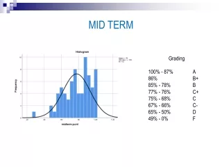
This document provides the answers to the mid-term exam for Introduction to GIS taught by Paul C. Sutton at the University of Denver in Spring 2008. It includes overall results with a mean score of 72.5 and detailed multiple-choice answers. Key concepts discussed include the relationship between scales, digital elevation models (DEMs), triangulated irregular networks (TINs), and the definition of GIS. It highlights practical applications of GIS in habitat preservation, evacuation analysis, and census data storage.

Mid-Term Answers: Introduction to GIS - Spring 2008
E N D
Presentation Transcript
Answers to Mid-Term Intro GIS Spring 2008 Paul C.Sutton psutton@du.edu Department of Geography University of Denver
Multiple Choice • Page 1: #1) D #2) E #3) A • Page 2: #4) D #5) B #6) B #7) D #8) C #9) E • Page 3: #10) A #11) E #12) B #13) D #14) D #15) B
The Globe and Scale • 1 meter to 40,000 km is 1:40 million scale • 10 cm to 1 meter is .1 & .1 of 40,000 km is 4,000 km If it takes 1 meter to go all the way around (40,000 km) it should take half a meter to go Half way around (20,000km) e.g. 50 cm
Many to One, One to Many oh my One to One relationship
DEM (Digital Elevation Model) DEMs are Rasters Good for representing A continuous surface And Hydro modeling
TIN Triangulated Irregular Network TINs are Vector Data – Basically Points with Elevation Attributed connceted via Delauney Triangulation Better for some rapid Geo-viz applications
What is a GIS? • The hardware, software, and human capital needed to store, manipulate, analyze, and display spatially referenced information. • Problems uniquely suited to GIS… • 1) Site selection for habitat preservation • 2) Evaculation analysis and Management • 3) Storing Census Data…..
Vector To Raster Conversion Rules you Use will Vary…