Download
1 / 20
200 likes | 396 Vues
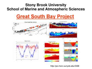
Stony Brook University School of Marine and Atmospheric Sciences. http://po.msrc.sunysb.edu/GSB. Great South Bay Observatory Funded by New York Department of State. Sensors deployed at the Bellport marina since 2004. Sea Bird Electronics “SeaCat”, SBE 16 and SBE 16Plus.

E N D
Stony Brook University School of Marine and Atmospheric Sciences http://po.msrc.sunysb.edu/GSB
Great South Bay Observatory Funded by New York Department of State
Sensors deployed at the Bellport marina since 2004 Sea Bird Electronics “SeaCat”, SBE 16 and SBE 16Plus Temperature and salinity Temperature, salinity, sea Level, chlorophyll and turbidity
April 9, 2005 C. Flagg
November 3, 2012 ~0900 EDT (~1300 GMT) C. Flagg and R. Giannotti
March 13, 2010 Hank Maust
Pre-inlet responses of the ocean and eastern bay to strong winds Low salinity river waters enter the bay High waves can over-top the dunes mean water level Waves scour the beach Bay waters flow up river
After the passage of Hurricane Irene, Aug. 28, 2011, ~1030 EDT C. Flagg
Pre-inlet responses of the ocean and eastern bay to strong winds Low salinity river waters enter the bay High waves can over-top the dunes mean water level Waves scour the beach Bay waters flow up river
Hurricane Sandy at Bellport Barometric Pressure Wind Speed North West Wind Direction South East North
Hurricane Sandy at Bellport Wind Speed Water level Water level with Tides removed Salinity Normal range
November 3, 2012 ~0900 EDT (~1300 GMT) C. Flagg and R. Giannotti
November 11, 2012, ~0830 EST (1330 GMT) C. Flagg and R. Giannotti
November 18, 2012 ~1200 EST (1700 GMT) R. Weissmann and R. Giannotti
November 29, 2012, ~0830 EST (~1330 GMT) C. Flagg and R. Giannotti
Different responses of the Bay to west winds pre and post inlet Inlet Water level, Tide removed Wind Speed Wind Direction
Post-inlet responses of the ocean and eastern bay to strong winds
Pre Inlet Post Inlet
Salient Points Bellport Bay's tidal range and phase have not been affected Response of the Bellport Bay to strong winds has been reversed but not necessarily increased in magnitude Water properties, ie salinity, have been altered and are more ocean-like due the increased exchange with the ocean