Attribute Data Input and Management
Attribute Data Input and Management . Chapter 6. Introduction. Spatial and attribute Attribute data are stored in tables Georelational data model stores spatial and attribute data in separate files, linked by feature id. Synchronized.

Attribute Data Input and Management
E N D
Presentation Transcript
Attribute Data Input and Management Chapter 6
Introduction • Spatial and attribute • Attribute data are stored in tables • Georelational data model stores spatial and attribute data in separate files, linked by feature id. • Synchronized. • Object-oriented data model stores spatial and attribute data in a single database. • No need to synchronize
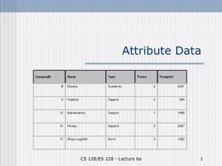
Attribute Data in GIS • Georelational data model links spatial data and attribute data by id. • Attribute data stored in feature atttribute table which contains the id. • Row is called a record, column is called a field or an item. • Database management system (DBMS) • Info, dBase, Oracle, Informix, SYBASE, Access, FoxPro, SQL Server, etc. • Object-oriented embeds GIS into database
Types of Attribute Data • Character, integers, floating points (or real numbers), dates, time intervals. • Measurement scale • Nominal (named) • Ordinal (ordered by some attribute) • Interval (known interval such as degree) • Ratio (based on meaningful absolute zero) • Categorical (n and o); Numerical (i and r)
Types of Attribute Data • Data types and measurement scales are closely related. • Character for nominal and ordinal • Integers and real for interval and ratio, depending on decimal needs • Most GIS can convert numbers to characters and vice versa. • Watch! Normally text left, number right justified
Relational Database Model • Flat file (ascii or txt) • Hierarchical database (family tree example) • Network database (connections developed) • Relational • Key • efficient, independent, temporary link
Relational Database Model • Constructing a relational database • Why? • General ideas. • Sample of Northwind with Microsoft Access on your computer. • Normalization
Types of Relationships • One-to-one • One-to-many • Many-to-one • Source table • Destination table
Attribute Data Management Using ArcView • Two functions • join (one table) • link (both tables remain • virtual tables
Attribute Data Management Using ARC/INFO • JOINITEM • one-to-one • many to one • permanent • exactly same item key • RELATE • one-to-one • many to one • temporary • CURSOR for “link-like”
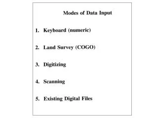
Attribute Data Entry • Field definition • data width • data type (must match GIS package) • number of decimal places • include spaces for negative sign and decimal point • Methods of data entry • avoid manual • import if possible
Attribute Data Entry Methods of data entry • UPDATE (one record at a time!) • look up table • take advantage of relational data model • use user-friendly cut and paste and then import
Attribute Data Verification • Woe is me! • Linked to spatial data • Accuracy of attribute data • Range and validity checking • Printing • Re-entry and compare • Expert spot check
Creating New Attribute Data from Existing Data • Simplify by reclassification • new field • select and fill • repeat • Attribute data computation • computation • weighting