THUNDERSTORMS AND WIND SHEAR
THUNDERSTORMS AND WIND SHEAR. Angela Lese National Weather Service Louisville. OUTLINE. Basic thunderstorm mechanics Wind shear How do we forecast wind shear? Preparation (examples in TAFs) Summary. The Thunderstorm. What is it? Rapidly rising column of air

THUNDERSTORMS AND WIND SHEAR
E N D
Presentation Transcript
THUNDERSTORMS AND WIND SHEAR Angela Lese National Weather Service Louisville
OUTLINE • Basic thunderstorm mechanics • Wind shear • How do we forecast wind shear? • Preparation (examples in TAFs) • Summary
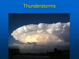
The Thunderstorm • What is it? • Rapidly rising column of air • Warmer than its surroundings • Ingredients • Moisture • Instability • Forcing/lifting mechanism • Front • Low pressure • Other boundary (outflow, lake breeze) • Upslope/Orography • Daytime heating
Thunderstorm Stages • All updraft • No rain/wind yet • Cumulonimbus/anvil • Heavy rain/wind/hail • All downdraft • Light rain/weak winds
Thunderstorm Hazards • Icing • Lightning • IFR and LIFR conditions • Turbulence/Wind shear
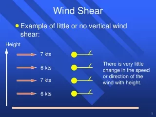
Wind Shear • What is turbulence? • Wind currents that vary greatly over short distances • What is wind shear? • A change in horizontal wind speed and/or direction with height • Two types of wind shear • Convective wind shear • Non-convective wind shear
Convective Wind Shear • Convective wind shear • Also known as microburst • Short-lived, ground-based, small-scale event • Associated with thunderstorms • Will be included in any TAF if: • Thunderstorms are expected at or in the vicinity of the airport
Fuzzy anvil: Icing Hard edges: Turbulent up to 20 miles away Under the storm: IFR/LIFR/VLIFR, Microbursts
MICROBURST LIFE CYCLE FORMATION Evaporation and precipitation drag forms downdraft IMPACT Downdraft quickly accelerates and strikes the ground DISSIPATION Downdraft moves away from point of impact
Glideslope Microburst X Y Z The aircraft encounters point X, where it enters the microburst zone, and a headwind causes it to rise above the normal glideslope. At the center of the microburst, point Y, there is a downdraft causing the aircraft to sink. The aircraft now enters the most dangerous zone, point Z, where a sudden tailwind causes the aircraft to lose airspeed and potentially crash. F-7-14-54
Non-convective Wind Shear • Non-convective wind shear • Also known as low-level wind shear (LLWS) • Longer-lived, large-scale velocity change with height • Usually associated with nocturnal low-level jet • LLWS will be included in any TAF if: • One or more PIREPs are received that include LLWS within 2,000 feet of surface, at or within vicinity of airport, causing an air speed loss or gain of 20 knots or more • Wind shear of 10 knots or more per 100 feet in a layer more than 200 feet thick are expected/reported at or within vicinity of airport
1,000 feet 500 feet Surface Non-convective Wind Shear WSW 50 knots SW 30 knots SE 10 knots
Forecasting Wind Shear • How are we forecasting microbursts? • Severe: greater than or equal to 50 knot gusts • Strong: roughly 30-40 knot gusts • Average: roughly 20 knot gusts • How are we forecasting LLWS? • If winds will be > 40 knots in lowest 2,000 feet with surface winds < 10 knots (> 30 knot change) • If wind direction will be > 60 degree difference between the surface and 2,000 feet • Question: how does this criteria suit you? • Would you like to see more liberal criteria?
Forecasting Wind Shear • What can we use? • For convective wind shear. . . • Radar velocity data • Surface observations • PIREPs • For non-convective wind shear. . . • RAOB soundings • Radar VWP • Profilers • ACARS/model soundings • PIREPs • Model forecasts
165o at 5 knots – 1100 feet 225o at 40 knots – 2200 feet • Radar Velocity • RAOB • VWP • Profiler • Surface Obs • ACARS sounding • PIREPs • Model forecasts
Preparation • Prepare ahead of time for your flight! • Monitor the TAFs at the appropriate airport and at surrounding airports • NWS homepage: weather.gov/louisville • Aviation Digital Data Service: adds.aviationweather.gov • But to be prepared, you must know the difference between convective and non-convective wind shear in TAFs
TAF Examples • Convective wind shear • FM1600 21008G20KT P6SM VCTS BKN040CB • FM1900 22010G35KT 3SM TSRA BR BKN035CB • FM2100 VRB20G55KT 1/2SM +TSRA FG BKN015CB • Non-convective wind shear • FM0900 19004KT P6SM SKC WS015/19040KT • FM0800 VRB02KT P6SM SCT010 WS010/22035KT • FM0200 17005KT P6SM SKC WS020/23055KT
Summary • Thunderstorms produce convective wind shear, which is short-lived, and localized • Microbursts (FAA may refer to this as ground-based wind shear) • Non-convective wind shear is longer-lived and on a larger scale • LLWS not associated with a thunderstorm • Low-level jet (often occurs in morning-nocturnal) • WS in TAF – non-convective wind shear • TS and gusts in TAFs – microburst • LLWA at airport – microburst • Help us by sending more PIREPs!!