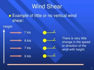
Low-Level Wind Shear
Low-Level Wind Shear. Anticipation, Avoidance & Forecasting. What is it?. “a change in horizontal wind speed and/or direction, and/or vertical speed with distance, measured in a horizontal and/or vertical direction.” Could be speed shear, directional shear or a combination of both

Low-Level Wind Shear
E N D
Presentation Transcript
Low-Level Wind Shear Anticipation, Avoidance & Forecasting
What is it? • “a change in horizontal wind speed and/or direction, and/or vertical speed with distance, measured in a horizontal and/or vertical direction.” • Could be speed shear, directional shear or a combination of both • Occurs within 2000 ft AGL
What about low-level turbulence? Turbulence Wind shear Fluctuations in airspeed (only momentary fluctuations in vertical speed) Prevailing winds at the top of the low level and the surface are similar Change in air speed accompanied by rapid change in vertical speed Wind speed and/or direction changes significantly from the top of the shear layer to the surface
What are the dangers? • Headwind at low level to tailwind at surface • With the loss of headwind, nose pitches down, • Pull nose up and further reduce air speed • Could lead to the plane landing short • Tailwind at low level to headwind at surface • Once headwinds are encountered, nose pitches up, air speed increases • Could lead to the plane landing long • Headwind or Tailwind at low level to crosswind at the surface • Much more of an impact to GA aircraft than larger commercial aircraft
Convective vs. non-Convective Convective Non-Convective Generally short-lived Radar is the best tool for detection, though increasingly difficult further away from the radar and in complex terrain Can last for hours Soundings, profilers, and radar can all be used for detection
Convective LLWS • Very hard to detect even with radar • Microburst, macroburst, and squall lines are most often associated with convective LLWS, but almost any storm has the potential to produce an outflow boundary • Not explicitly stated in the TAF, however, it is to be assumed whenever TS is forecasted • If storms are expected to strong outflow winds, a variable convective wind group may be included (VRB25G40KT)
July 22, 2011 case 20:03Z – 20:54Z
Non-Convective LLWS • Causes: • Frontal Passage • Inversion • Low-Level Jet • Sea breeze front • Other local effects • Explicitly stated in the TAF • Slightly easier to detect and forecast than convective LLWS, but still one of the most difficult TAF elements
Non-Convective LLWS in a TAF • If it is included it will be after any cloud groups • Often the last group in a line (only PROB30 could come after it) • Format • WShhh/dddssKT Wind speed at top of the WS layer Wind direction at top of the WS layer Height of the top of the WS layer (WS should be expected below this altitude) in hundreds of ft. AGL to 020
Non-Convective LLWS in a TAF KAMA 102320Z 1100/1124 22015KT P6SM SCT050 FM110130 33025KT P6SM SKC WS010/15050KT FM110400 35011KT P6SM SCT030 FM111100 01015KT P6SM BKN050= WS010/15050KT • Top of the wind shear layer is 1000 ft. • The wind at 1000 ft. is southeasterly (150˚) at 50 KT
Frontal Passage • Can occur with a warm, cold, stationary, or occluded front • The slower and more shallow the front, the more impact of LLWS From: DLAC 2 Writing TAFs for Winds and Low-Level Wind Shear http://www.meted.ucar.edu/dlac2/mod3/main.htm
Other local effects • Generally terrain influenced (Gap winds, valley, canyon and mountain effects) • Knowledge of the surrounding terrain and climatology is key for understanding and anticipating From: DLAC 2 Writing TAFs for Winds and Low-Level Wind Shear http://www.meted.ucar.edu/dlac2/mod3/main.htm
Data Resources for LLWS • Wind Profilers • VAD wind profiles • Soundings • Aircraft and Pilot observations (ACARS/MDCRS/TAMDAR/PIREPS) • TAF and AIRMET (http://www.aviationweather.gov/products/gairmet/)
Wind profilers • Available at: http://www.profiler.noaa.gov/npn/profiler.jsp • Very few in the Southwestern region
VAD Wind Profile • Derived from WSR-88D (weather radar) data • More extensive coverage than wind profilers • Data may be limited in areas of mountainous terrain or with few echoes on radar • Data may be unrepresentative if a wind shift is present Image courtesy of Radar Operations Center http://www.roc.noaa.gov/WSR88D/Maps.aspx
Soundings • Available at: http://www.spc.noaa.gov/exper/soundings/
PIREPS: Help us help you! • For most airports, PIREPs are the only direct verification of LLWS • Often times, LLWS can occur an non-peak times, and thus you may be the first to experience the LLWS
LLWS forecasting • Arguably the least understood TAF element among forecasters • So how do we increase forecaster situational awareness of LLWS? • Training • In practice?
Initial Feedback • Overwhelmingly positive feedback from forecasters • This, combined with feedback from local GA pilots, has posed the question, are we over forecasting LLWS in low level jet scenarios? • Traditional “rules of thumb” may not accurately express LLWS conditions • “I had to put in some pretty extreme winds to get any response” • Increased awareness of LLWS with fronts • Another question that has been raised is how to handle LLWS associated with outflow boundaries of storms that are far away or have already dissipated
References • Arkell, R. 2000: Differentiating Between Types of Wind Shear in Aviation Forecasting. Natl. Wea. Dig., 24:3, 39-51. • National Weather Service, 2008: National Weather Service Instruction 10-813. Available at http://www.weather.gov/directives/sym/pd01008013curr.pdf. • National Weather Service, 1979: NOAA Technical Memorandum NWS FCST-23; “Low-Level Wind Shear: A critical review” • Sinclair, P. and Kuhn, P., 1991: Aircraft Low Altitude Wind Shear Detection and Warning System. J. Appl. Meteor.,30, 3-16. • University Corporation for Atmospheric Research, 2008: “Writing TAFs for Winds and Low-Level Wind Shear.” Available at http://www.meted.ucar.edu/dlac2/mod3/index.htm