Download

1 / 36
470 likes | 1.07k Vues
A Look at Low Level Wind Shear. Southwest Aviation Weather Safety Workshop. Phoenix, AZ Ken Widelski Meteorologist NWS: Lubbock, TX. Objectives. What is Low Level Wind Shear? Speed versus Directional Non-Convective Wind Shear Convective Wind Shear

E N D
A Look at Low Level Wind Shear Southwest Aviation Weather Safety Workshop. Phoenix, AZ Ken Widelski Meteorologist NWS: Lubbock, TX
Objectives • What is Low Level Wind Shear? • Speed versus Directional • Non-ConvectiveWind Shear • ConvectiveWind Shear • Pre-Flight Planning/In-Flight Precautions • Recap • Questions??
What is Low Level Wind Shear? • A change in the wind direction or speed within 2000 ft AGL. • This condition can present danger to aircraft, especially at landing, when a sudden shift from headwind to tailwindcan cause a rapid loss of airspeed and lift.
Many Sources of LLWS • “Low Level Jet” (*) -Strong winds above an inversion • Weather Fronts (*) • Thunderstorms: Microburst (*) • Mountain waves • Gap winds • Sea and land breezes KEY: LLWS can be convective and non- convective
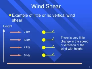
Speed versus Directional • Speed Shear: is the change in wind speed with height. In the illustration, the wind is increasing with height
Directional Shear is a change in wind direction with height. • Surface flow is southeast. Winds veer (clockwise) turning to south-southeast and south.
Non-Convective LLWS • Change in wind direction or speed within 2000 ft AGL. • The most common type of LLWS • Occurs over a larger area • Longer periods of time • Easier to detect • Usually associated with a “Low Level Jet”
Aspects of the “Low Level Jet” • A narrow band of strong winds in the lower atmosphere. • Stronger winds Typically above a Radiative inversion
LLJ Characteristics • Under the inversion top… -Conditions are usually stable with light winds. • Above the inversion top… -Winds can suddenly change up to 90 degrees in direction and up to 40 KTS in speed. • Can pose a serious hazard to aircraft.
LLJ Flight ImplicationsCourtesy of Hong Kong Weather Service • When an aircraft departing from the airport ascends and enters the “jet”, it experiences increasing headwind and lift. • As it departs the “jet”, however the headwind and lift decrease.
Frontal Passages • Frontal passages can bring dramatic shifts in… Surface wind strength Surface wind direction • The more vigorous the front = Stronger the Wind shift = Better chance for Low Level Wind Shear
Frontal Type-Cold Front • Frontal Passages can be large scale -Dense cold air rapidly digs in (Back)
Frontal Type-Warm Front • Warm air gently slopes over cooler surface air (Veer).
Small Scale Boundaries • Outflow boundaries form from decaying thunderstorms. • Cooler and more stable air spreads out in all directions. • Convection is suppressed in this area. • Looks benign but can be the focus for LLWS and new convection
Convective Wind Shear • Affects a localized area • Main form: Microburst What is a Microburst? A microburst is a very localized column of sinking air, producing damaging divergent and straight-line winds at the surface.
Microburst Size: -less than 1 mile in diameter as it descends from the cloud base to about 1,000-3,000 feet above the ground. In the transition zone near the ground, the downdraft changes to a horizontal outflow that can extend to approximately 2 1/2 miles in diameter. • Microburst Intensity: The downdrafts can be as strong as 6,000 feet per minute. Horizontal winds near the surface can be as strong as 45 knots resulting in a 90 knot shear (headwind to tailwind change for a traversing aircraft) across the microburst. These strong horizontal winds occur within a few hundred feet of the ground.
What are the dangers? • The scale and suddenness of a microburst makes it a great danger to aircraft, particularly those at low altitude which are taking off and landing. • As the aircraft is coming in to land, the pilots try to slow the plane to an appropriate speed.
When the microburst hits, pilots will see a large spike in their airspeed, caused by the force of the headwind created by the microburst • An initial response would be to decrease the speed of the aircraft. • The plane would then travel through the microburst, and fly into the tailwind, causing a sudden decrease in the amount of air flowing across the wings
The sudden loss of air moving across the wings causes the aircraft to literally drop out of the air.
Pre-Flight Planning • The NWS offers a host of data for pre-flight planning. Aviation Area Forecast Discussion: -Generally at TAF issuance TAF: Terminal Forecasts: -4 routine issuances per day TWEB: Transcribed Weather Broadcast -4 routine issuances per day
Aviation discussion • More direct insight into the TAF Reasoning. • Example: NATIONAL WEATHER SERVICE 245 PM MDT WED APR 4 2007 WIDESPREAD MVFR CIGS WITH SOME LCL IFR NEAR THE BLKHLS WILL CONTINUE THROUGH THE AFTERNOON. CONDITIONS ARE EXPECTED TO DETERIORATE LATER THIS EVENING FROM WEST TO EAST AS AREAS OF SNOW START TO DEVELOP AND CIGS DROP TO IFR IN SOME LOCATIONS.
Experimental AFD Pagehttp://aviationweather.gov/testbed/afd/
LLWS in the TAF NWSI 10-813: Feb 2005 • Only refers to non-convective LLWS from the surface up to 2000 FT AGL. • Reason: LLWS is always assumed to be present in convective activity. • When LLWS conditions are expected the code WS will be added to the FM prevailing group.
LLWS TAF Format • WS: Non-convective LLWS • hwshwshws: Height of the top of the WS layer in hundreds of feet AGL • ddd: True direction in ten degree increments at the indicated height • ff: Speed in knots of the forecast wind at the indicated height. • KT: Unit indicator for wind
TAF Example KPUB 181122Z 181212 13012KT 5SM –RA SCT010 OVC035 WS020/27055KT FM1400 32010KT P6SM FEW008 BKN045 WS020=Top of the wind shear layer 27055KT=Wind direction and speed at the top of the layer. Not a value for the amount of shear.
RAOB: Sounding data: 12z and 00z -Occasional 18z sounding for severe weather.
AOPA: Aircraft Owners and Pilots Association recommends… • If forecasts mention low level wind shear, be prepared to go around and carry extra airspeed on approach. • Usual recommendation is: -Add ½ the gust factor to your usual 1.3 Vso approach speed. EX: If the wind is 10 gusting to 20 KTS Add 5 KTS to your handbook’s target airspeed for final approach.
Additional Help… • Consider using partial flaps for your landing in gusty or shear conditions. -The extra lift and drag caused by the full flaps may hinder your ability to preserve any semblance of a stabilized approach and may lead to control problems.
And Finally… • Remember that you do have an out. • You can abandon the approach at the first signs of trouble.
Recap • LLWS can contain speed, direction or a combination of both. • 2 types of LLWS: Convective Non-Convective • Convective: Localized, small scale • Non-Convective: Most common form Larger scale More widespread Easier to detect
Many NWS tools available for pre-flight planning. Main one’s include… AVN Discussion TAF TWEB RAOB • AOPA wind shear recommendations • Still unsure: Contact your local NWS office for a personalized forecast 24/7/365.
References • NWSI 10-813 Aviation Directive • AOPA: Aircraft Owners and Pilots Association: Wind Shear Awareness and Coping Strategies • FAA: Flight Safety, Dangers of Microbursts • Aviation Weather Center: AWC • Weather Service, Hong Kong • Wikipedia.org
Thank you for attending: Any Questions?