Download
1 / 8
80 likes | 254 Vues
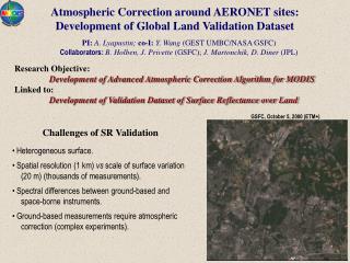
Atmospheric Correction around AERONET sites: Development of Global Land Validation Dataset. PI: A. Lyapustin; co-I: Y. Wang (GEST UMBC/NASA GSFC) Collaborators: B. Holben, J. Privette (GSFC); J. Martonchik, D. Diner (JPL). Research Objective:

E N D
Atmospheric Correction around AERONET sites: Development of Global Land Validation Dataset PI: A. Lyapustin; co-I: Y. Wang (GEST UMBC/NASA GSFC) Collaborators:B. Holben, J. Privette (GSFC); J. Martonchik, D. Diner (JPL) Research Objective: Development of Advanced Atmospheric Correction Algorithm for MODIS Linked to: Development of Validation Dataset of Surface Reflectance over Land GSFC, October 5, 2000 (ETM+) • Challenges of SR Validation • Heterogeneous surface. • Spatial resolution (1 km) vs scale of surface variation (20 m) (thousands of measurements). • Spectral differences between ground-based and space-borne instruments. • Ground-based measurements require atmospheric correction (complex experiments).
ASRVN - AERONET-based Surface Reflectance Validation Network • THEORETICAL BASIS • 3D Radiative Transfer(Lyapustin & Knyazikhin, Appl. Opt., 2001; 2002) • variable anisotropic surface; • arbitrary spatial resolution; • semi-analytical, accurate and fast due to parameterizations. • Accurate Modeling of Gaseous Absorption • Inversion with MRPVMISR and LSRTMODIS BRF Models • PRODUCTS • BRF, Albedo (spectral & SW broadband) • Surface Radiative Fluxes, PAR • EXPECTED BENEFITS • Validation of BRF & Albedo over Heterogeneous Surfaces • MODIS-MISR Data Fusion • Calibration Analysis • Vicarious calibration • Cross-calibration of different sensors • Detection of calibration trend based on a time series of surface reflectance. MISR MODIS ETM+ SeaWIFS VIIRS
March 19 May 21 June 22 July 24 August 25 September 26 October 28 March 19 June 22 October 28 Study Area: 1. Mongu (Zambia) (15o15’S, 23o09’E), H=1,104 m 2. GSFC (USA) (39o03’N, 76o88’W), H=50 m Albedo Time Series (Mongu, 2003) Vis. (RGB) and NIR (grey) from MISR Collection 4 Data
Mongu, March 18, 2003 Mongu, July 8, 2003 View Zenith Angle Analysis of BRF Solid lines – MISR radiance/BRF Squares – ASRVN BRF (MRPV algorithm) Triangles – model BRF calculated with the best-fit parameters (MRPV) • MISR retrieves correct BRF shape. • MISR BRF is less anisotropic than the ASRVN BRF in the Vis. • (analysis: in IEEE TGARS Special Issue on Land Product Validation)
Analysis of Albedo MISR AOT AERONET ASRVN MISR • MISR correctly reproduces the time series of albedo. • MISR albedo is on average lower by about 0.005 in the green and red bands.
Mongu, July 24, 2003 Blue Green Red NIR GSFC, August 24, 2003 Blue Green Red NIR MRPV-MISR LSRT-MRPV Analysis of Albedo Spatial Distribution • MISR correctly reproduces spatial distribution of albedo. • An albedo mosaic may develop due to MISR aerosol retrievals at 17.6 km resolution. • ASRVN albedo does not have model-dependent distortions from the variable land cover.
Summary of Results (local analysis) MISR 1. MISR BRF and albedo products are generally accurate in both clear and hazy atmospheric conditions. 2. MISR correctly reproduces the time series and spatial distribution of albedo. 3. MISR BRF on average is less anisotropic than actual BRF in the visible bands. The difference is greatest in the blue band, decreases with wavelength, and it is negligible in the near-IR band. This discrepancy most likely originates in 1) MISR aerosol retrieval algorithm over heterogeneous land, which tends to select an aerosol model that benefits the spectrally invariant shapes of surface BRF; 2) MISR surface HDRF retrieval algorithm where the iteration loop that removes the diffuse atmospheric transmittance is currently turned off. 4. Our initial results suggest that the MISR surface albedo is on average lower than the ASRVN albedo by about 0.005 in the green and red bands. BRF Model (LSRT vs MRPV) 1. MRPV model fits BRF shapes slightly better than LSRT model, except in the blue band. 2. The AC algorithm based on LSRT model is much faster and more robust (due to linearity). 3. The albedos from the two models are generally similar, with the average difference q0.005. The difference q is spatially homogeneous but site-dependent (function of aerosol absorption).
What is Next … • MISR • ASRVN is receiving and processing operational MISR collection 5 data (0.5 Yr in 2000, and since Dec. 2004) for all AERONET stations (166). We plan to carry on MISR validation analysis on the regional and then global scales. • The web-interface with data analysis tools is under development. • ETM+ • The ASRVN_ETM+ processing algorithm is being finalized (1 month). • ASRVN_ ETM+ products will become available this summer. • MODIS • Cooperating with Goddard Earth Sciences Data & Information Services Center (G. Leptouch, D. Ouzounov) to produce MODIS Collection 5 subsetted and aggregated data for ASRVN. • Operational ASRVN_ MODIS products will become available this fall.